geo.wikisort.org - Coast
The Taymyr Peninsula (Russian: Полуостров Таймыр, Таймырский полуостров) is a peninsula in the Far North of Russia, in the Siberian Federal District, that forms the northernmost part of the mainland of Eurasia. Administratively it is part of the Krasnoyarsk Krai Federal subject of Russia.
Полуостров Таймыр | |
|---|---|
 Location of the Taymyr Peninsula. | |
| Geography | |
| Location | Far North |
| Coordinates | 74°N 98°E |
| Adjacent to | |
| Area | 400,000 km2 (150,000 sq mi) |
| Length | 1,050 km (652 mi) |
| Width | 520 km (323 mi) |
| Highest elevation | 1,125 m (3691 ft) |
| Highest point | Byrranga Mountains |
| Administration | |
| Federal subject | Krasnoyarsk Krai |
Geography
The Taymyr Peninsula lies between the Yenisei Gulf of the Kara Sea and the Khatanga Gulf of the Laptev Sea.
Lake Taymyr and the Byrranga Mountains are located within the vast Taymyr Peninsula.
Cape Chelyuskin, the northernmost point of the Afro-Eurasian continent, is located at the northern end of the Taymyr Peninsula.
Population

The Nenets people, also known as Samoyeds, are an indigenous people in northern arctic Russia, and some live at the Taymyr Peninsula.
The Nganasan people are an indigenous Samoyedic people inhabiting central Siberia, including the Taymyr Peninsula. In the Russian Federation, they are recognized as being one of the Indigenous peoples of the Russian North. They reside primarily in the settlements of Ust-Avam, Volachanka, and Novaya in the Taymyrsky Dolgano-Nenetsky District of Krasnoyarsk Krai, with smaller populations residing in the towns of Dudinka and Norilsk as well.[1][full citation needed] The isolated location of the Nganasan people enabled them to maintain shamanistic practices even in the 20th century.[2]
Economy
MMC Norilsk Nickel conducts mining operations in the area. The company conducts smelting operations in the area of the city of Norilsk, near the peninsula. The nickel ore concentrate and other products of the company are transported over a short railroad to the port city of Dudinka on the Yenisei River, and from there by boat to Murmansk and other ports.
Ecology
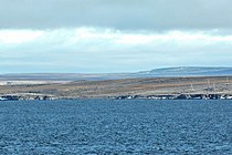 Cape Chelyuskin, northernmost point of Russian and of Afro-Eurasian mainland; 77°43’22’’N, 104°15’13’’E
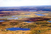 Taymyr landscape
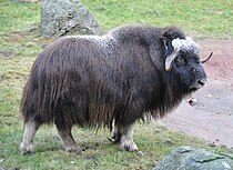 Muskox, an Arctic mammal of the family Bovidae, successfully reintroduced to the Taymyr Peninsula region in 1975


The peninsula is the site of the last known naturally occurring muskox outside of North America, which died out about 2,000 years ago.[3] They were successfully reintroduced in 1975.[4] The population grew to 2,500 animals in 2002 increasing to 6,500 in 2010.[5]
Climate
The coasts of the Taymyr Peninsula are frozen most of the year, between September and June on average. The summer season is short, especially on the shores of the Laptev Sea in the northeast. The climate in the interior of the peninsula is continental - Tundra Climate (ET). Winters are harsh, with frequent blizzards and extremely low temperatures. The following data for Cape Chelyuskin provides an indication of the weather experienced in the northern part of the peninsula.
| Climate data for Cape Chelyuskin | |||||||||||||
|---|---|---|---|---|---|---|---|---|---|---|---|---|---|
| Month | Jan | Feb | Mar | Apr | May | Jun | Jul | Aug | Sep | Oct | Nov | Dec | Year |
| Average high °C (°F) | −26 (−15) |
−26 (−15) |
−24 (−11) |
−16 (3) |
−8 (18) |
1 (34) |
5 (41) |
4 (39) |
0 (32) |
−10 (14) |
−19 (−2) |
−22 (−8) |
−12 (11) |
| Average low °C (°F) | −33 (−27) |
−33 (−27) |
−33 (−27) |
−26 (−15) |
−15 (5) |
−5 (23) |
−3 (27) |
−3 (27) |
−5 (23) |
−16 (3) |
−26 (−15) |
−30 (−22) |
−19 (−2) |
| Average precipitation mm (inches) | 8 (0.3) |
9 (0.4) |
9 (0.4) |
8 (0.3) |
9 (0.4) |
18 (0.7) |
21 (0.8) |
22 (0.9) |
22 (0.9) |
15 (0.6) |
9 (0.4) |
11 (0.4) |
201 (7.9) |
| Average precipitation days | 15 | 15 | 14 | 12 | 11 | 12 | 11 | 12 | 15 | 16 | 13 | 16 | 162 |
| Mean monthly sunshine hours | 0 | 0 | 124 | 270 | 217 | 150 | 186 | 124 | 62 | 0 | 0 | 0 | 1,133 |
| Source: World Climate Guide[6] | |||||||||||||
See also
- Siberia
- Taymyr Strait
 Siberia portal
 Russia portal
 Geography portal
References
- Ziker
- Hoppál 2005
- BioMed Central (6 October 2005). "Muskox Suffered Loss Of Genetic Diversity At Pleistocene/Holocene Transition" – via Science Daily.
- "Greenland Muskox". Bovids. Safari Club International. Archived from the original on 2007-09-27.
- Dr. Taras Sipko. "Reintroduction of Musk Ox in the Northern Russia". Large Herbivore Network. Archived from the original on 2015-09-05.
- "Climate Data for Mys Chelyuskin". World climate Guide. Retrieved April 1, 2012.
Bibliography
- Hoppál, Mihály (2005). Sámánok Eurázsiában (in Hungarian). Budapest: Akadémiai Kiadó. ISBN 9630582953. (The title means “Shamans in Eurasia”, the book is written in Hungarian, but it is published also in German, Estonian and Finnish: Site of publisher with short description on the book (in Hungarian) Archived 2010-01-02 at the Wayback Machine.)
External links
Earth's primary regions and subregions | |||||||||||||||||||||||||||||||||||||||||||||||||||||
|---|---|---|---|---|---|---|---|---|---|---|---|---|---|---|---|---|---|---|---|---|---|---|---|---|---|---|---|---|---|---|---|---|---|---|---|---|---|---|---|---|---|---|---|---|---|---|---|---|---|---|---|---|---|
| |||||||||||||||||||||||||||||||||||||||||||||||||||||
Authority control | |
|---|---|
| General | |
| National libraries | |
На других языках
[de] Taimyrhalbinsel
Die Taimyrhalbinsel (russisch Таймы́рский полуо́стров .mw-parser-output .Latn{font-family:"Akzidenz Grotesk","Arial","Avant Garde Gothic","Calibri","Futura","Geneva","Gill Sans","Helvetica","Lucida Grande","Lucida Sans Unicode","Lucida Grande","Stone Sans","Tahoma","Trebuchet","Univers","Verdana"}Taimyrski poluostrow) ist eine etwa 400.000 km² große Halbinsel zwischen Kara- und Laptewsee (Nordpolarmeer) im Norden der Region Krasnojarsk (früher Autonomer Kreis Taimyr) sowie von Sibirien und Russland (Asien) und ist der nördlichste kontinentale Festlandteil der Erde.- [en] Taymyr Peninsula
[es] Península de Taimyr
La península de Taimyr (en ruso, Полуостров Таймыр, Таймырский полуостров) es una gran península de Rusia, ubicada en la zona de Siberia, que forma la parte más septentrional del continente asiático. Se encuentra delimitada por las aguas del golfo del Yeniséi, al oeste; las del mar de Kara, al norte; y las del golfo de Játanga del mar de Láptev, al este; al sur, su límite continental está formado por el curso del río Játanga.[ru] Таймыр
Таймы́р (Таймы́рский полуо́стров) — крупнейший полуостров в России, самая северная материковая часть суши Евразийского континента, расположен между Енисейским заливом Карского моря и Хатангским заливом моря Лаптевых. Площадь — 400 000 км2. По характеру поверхности делится на три части: Северо-Сибирская низменность, горы Бырранга (высота до 1125 метров), тянущиеся с юго-запада на северо-восток, и равнина вдоль побережья Карского моря. Южной границей полуострова считается северный уступ Среднесибирского плоскогорья[1]. На севере Таймыра расположен глубоко вдающийся в море полуостров Челюскин с одноимённым мысом.Другой контент может иметь иную лицензию. Перед использованием материалов сайта WikiSort.org внимательно изучите правила лицензирования конкретных элементов наполнения сайта.
WikiSort.org - проект по пересортировке и дополнению контента Википедии