geo.wikisort.org - Mountains
The Volcán de Colima, 3,820 m (12,533 ft), also known as Volcán de Fuego, is part of the Colima Volcanic Complex (CVC) consisting of Volcán de Colima, Nevado de Colima (Spanish pronunciation: [neˈβaðo ðe koˈlima] (![]() listen))[3] and the eroded El Cántaro (listed as extinct). It is the youngest of the three and as of 2015 is one of the most active volcanos in Mexico and in North America. It has erupted more than 40 times since 1576. One of the largest eruptions was on January 20–24, 1913.[4] Nevado de Colima, also known as Tzapotépetl, lies 5 kilometres (3.1 mi) north of its more active neighbor and is the taller of the two at 4,271 meters (14,015 ft). It is the 26th-most prominent peak in North America.[5]
listen))[3] and the eroded El Cántaro (listed as extinct). It is the youngest of the three and as of 2015 is one of the most active volcanos in Mexico and in North America. It has erupted more than 40 times since 1576. One of the largest eruptions was on January 20–24, 1913.[4] Nevado de Colima, also known as Tzapotépetl, lies 5 kilometres (3.1 mi) north of its more active neighbor and is the taller of the two at 4,271 meters (14,015 ft). It is the 26th-most prominent peak in North America.[5]
| Volcán de Colima | |
|---|---|
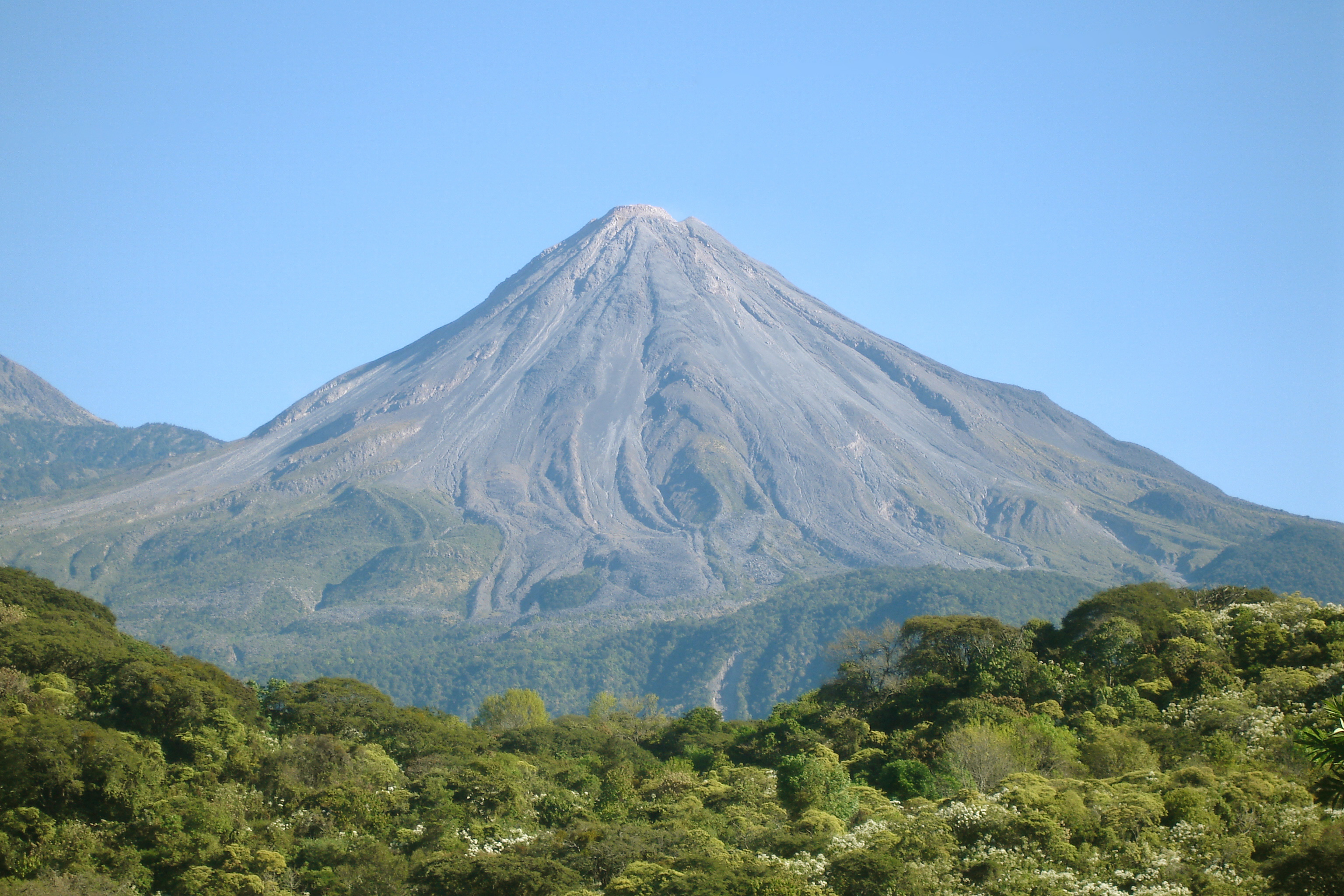
 Volcán de Colima is on the left with Nevado de Colima on the right. | |
| Highest point | |
| Elevation | 3820+ m (12,533+ ft)[1] |
| Prominence | 600 m (2,000 ft)[1] |
| Listing |
|
| Coordinates | 19°30′46″N 103°37′02″W[1] |
| Geography | |
 Volcán de Colima Location in Mexico | |
| Location | Jalisco / Colima, Mexico |
| Parent range | Trans-Mexican Volcanic Belt |
| Geology | |
| Age of rock | 5 million years |
| Mountain type | Stratovolcano |
| Volcanic arc/belt | Trans-Mexican Volcanic Belt |
| Last eruption | 2013 to 2018 (ongoing)[2] |


Despite its name, only a fraction of the volcano's surface area is in the state of Colima; the majority of its surface area lies over the border in the neighboring state of Jalisco, toward the western end of the Trans-Mexican Volcanic Belt. It is about 485 km (301 mi) west of Mexico City and 125 km (78 mi) south of Guadalajara, Jalisco.
Since 1869–1878, a parasitic set of domes, collectively known as El Volcancito, has formed on the northeast flank of the main cone of the volcano.[6]
Geological history
In the late Pleistocene era, a huge landslide occurred at the mountain, with approximately 25 km³ (6 cubic miles) of debris traveling some 120 km, reaching the Pacific Ocean. An area of some 2,200 km² was covered in landslide deposits. The currently active cone is within a large caldera that was probably formed by a combination of landslides and large eruptions. The lava is andesite containing 56-61% SiO2.[7] About 300,000 people live within 40 km (25 miles) of the volcano, which makes it the most dangerous volcano in Mexico.[4] In light of its history of large eruptions and situation in a densely populated area, it was designated a Decade Volcano, singling it out for study.
Current activity
In recent years there have been frequent temporary evacuations of nearby villagers due to threatening volcanic activity. Eruptions have occurred in 1991, 1998–1999 and from 2001 to the present day, with activity being characterized by extrusion of viscous lava forming a lava dome, and occasional larger explosions, forming pyroclastic flows and dusting the areas surrounding the volcano with ash and tephra.
The largest eruption for several years occurred on May 24, 2005. An ash cloud rose to more than 3 km over the volcano and satellite monitoring indicated that the cloud spread over an area extending 110 nautical miles (200 km) west of the volcano in the hours after the eruption.[8] Pyroclastic flows travelled 4–5 km from the vent, and lava bombs landed 3–4 km away. Authorities set up an exclusion zone within 6.5 km of the summit.
On November 21, 2014, the volcano erupted again. An ash column was sent 5 km into the air, covering towns as far as 25 km away in ash. No fatalities were reported, and no evacuations took place.[citation needed] There were eruptions on January 10, 21 and 25, with the ash from the January 21 eruption falling in towns more than 15 miles (24 km) away.[9][10]

On 10 July 2015, there was another eruption. Another eruption occurred on Sunday, September 25, 2016, sending a plume of ash and smoke 10,000 feet (3048 m) into the sky. During December 2016, ash plumes occurred once or twice a day. On Sunday, December 18, 2016, there were three eruptions. The biggest columns of ash reached 2 kilometers in height.[11]
Colima volcano experienced another strong explosion at 06:27 UTC (00:27 CST) on January 18, 2017. The eruption spewed volcanic ash up to 4 km (13,123 feet) above the crater.
Volcanological center
The volcano is monitored by the Colima Volcano Observatory at the University of Colima, Mexico. A team analyzes, interprets and communicates every event that occurs at this volcano.
In 2018, a webcam was installed close to the volcano, and volcanic activity can be seen in real-time.[12]
References
- Notes
- "Volcán de Colima, Mexico". Peakbagger.com.
- "Colima volcano". 19 Feb 2018.
- "The Colima Volcanic Complex, Mexico" (PDF). Mineralogy and Petrology. Retrieved 2012-05-04.
- Ritchie, David (2006). Encyclopedia of Earthquakes and Volcanoes. Alexander E. Gates, Ph.D., and David Ritchie. p. 52.
- "North America Peaks with 2000 meters of Prominence". Peakbagger.com. Retrieved 2012-05-03.
- "Structure of the Volcancito Dome, Volcan Fuego De Colima, Mexico, Revealed in High Resolution Magnetic Anomalies". confex.com. Archived from the original on 2009-02-23. Retrieved 2006-07-23.
- http://www.geo.mtu.edu/EHaz/ConvergentPlatesClass/Colima/Luhr%20Colima%20andesite.pdf James F. Luhr and Ian S.E. Carmichael, 1980: The Colima Volcanic Complex, Mexico in Contributions to Mineralogy and Petrology, Vol. 71, page 347
- http://www.ssd.noaa.gov/VAAC/ARCHIVE/COLI/2005E240658.html%5B%5D
- "VIDEO: Mexico's Colima Volcano spews enormous cloud of ash". NY Daily News.
- "Footage of huge ash plume as Mexico's Colima volcano erupts". BBC News. 25 January 2015. Retrieved 27 January 2015.
- "Mexico's Colima Volcano Spews Ash, Vapor a Mile Into the Air". New York Times. December 18, 2016. Retrieved December 18, 2016.
- "Volcán de Colima". www.webcamsdemexico.com. Retrieved 2018-12-26.
- Bibliography
- Domínguez T., Ramírez J.J., Breton M. (2003), Present Stage Of Activity At Colima Volcano, Mexico, American Geophysical Union, Fall Meeting 2003, abstract #V42B-0350
External links
 Definitions from Wiktionary
 Media from Commons
 News from Wikinews
 Quotations from Wikiquote
 Texts from Wikisource
 Textbooks from Wikibooks
 Resources from Wikiversity
- Universidad de Colima, Observatorio Vulcanológico (in Spanish)
- Universidad de Colima, Centro de Intercambio e Investigación en Vulcanología (in English and Spanish)
- Experiments at Colima by the Alaska Volcano Observatory
- "Colima". Global Volcanism Program. Smithsonian Institution. Retrieved 2009-01-14.
- "Volcán de Colima". SummitPost.org. Retrieved 2016-12-03.
Guadalajara (capital) | ||
| Topics |
|  |
| Metropolitan areas |
| |
| Municipalities and (municipal seats) |
| |
| Protected areas |
| |
Authority control | |
|---|---|
| General |
|
| National libraries | |
На других языках
[de] Colima (Vulkan)
Der Colima ist ein mexikanischer Vulkan und besteht aus zwei Erhebungen: dem älteren und inaktiven Nevado de Colima (4330 m), auch Zapotepetl genannt, sowie dem jüngeren und sehr aktiven Volcán de Colima (3850 m), welcher etwas südlicher liegt und auch als Volcán de Fuego de Colima bekannt ist.[1] Er ist der aktivste Vulkan Mexikos.- [en] Volcán de Colima
[es] Volcán de Colima
El volcán de Colima, a veces llamado Volcán de Fuego de Colima para diferenciarlo del cercano Volcán Nevado de Colima, es un estratovolcán activo ubicado en los límites de los estados de Colima y Jalisco, en México. Su altitud oficial es de 3,960 m sobre el nivel del mar.[2][3] Sin embargo, debido a la constante actividad volcánica que ha presentado durante los últimos años, resulta difícil determinar con exactitud la altitud actual.[cita requerida][fr] Volcán de Colima
Le Volcán de Colima, également appelé Colima, Fuego de Colima, Volcán de Fuego ou encore Tzapoltlan[2], est un volcan du Mexique faisant partie de la cordillère néovolcanique[3]. Il est situé dans le parc national Nevado de Colima.[it] Volcán de Colima
Il Volcán de Colima (3.860 m s.l.m.), chiamato anche Volcán de Fuego de Colima), è il più attivo vulcano del Messico e dista solo 5 km dal più vecchio e inattivo Nevado de Colima (4330 m s.l.m.). Si trova quasi al limite occidentale della Fascia Vulcanica Trasversale, di cui fa parte. Nonostante il suo nome, solo una sua piccola parte rientra nello Stato di Colima, mentre per la maggior parte appartiene allo Stato di Jalisco.[ru] Колима (вулкан)
Коли́ма (исп. Volcán de Colima) — вулкан на западе Мексики, расположен в штате Халиско, в Вулканической Сьерре, в 80 км от берега Тихого океана. Наиболее активный вулкан Мексики, извергался более чем 40 раз с 1576 года.Другой контент может иметь иную лицензию. Перед использованием материалов сайта WikiSort.org внимательно изучите правила лицензирования конкретных элементов наполнения сайта.
WikiSort.org - проект по пересортировке и дополнению контента Википедии