geo.wikisort.org - Mountains
Avachinsky (also known as Avacha or Avacha Volcano or Avachinskaya Sopka) (Russian: Авачинская сопка, Авача) is an active stratovolcano in Russia. It is situated on the Kamchatka Peninsula in the Russian Far East. Avachinsky lies within sight of Petropavlovsk-Kamchatsky, the capital of Kamchatka Krai. Together with neighboring Koryaksky volcano, it has been designated a Decade Volcano, worthy of particular study in light of its history of explosive eruptions and proximity to populated areas.
| Avachinsky | |
|---|---|
 | |
| Highest point | |
| Elevation | 2,741 m (8,993 ft)[1] |
| Prominence | 1,550 m (5,090 ft) |
| Listing | Ultra |
| Coordinates | 53°15′18″N 158°49′48″E[1] |
| Geography | |
 Avachinsky The location of Avachinsky in Russia | |
| Location | Kamchatka, Russia |
| Parent range | Eastern Range |
| Geology | |
| Age of rock | Pleistocene |
| Mountain type | Stratovolcano |
| Last eruption | 2001[1] [2] |
| Climbing | |
| Easiest route | basic rock/snow climb |
Avachinsky's last eruption occurred in 2008. This eruption was tiny compared to the volcano's major Volcanic Explosivity Index 4 eruption in 1945.
Geological history
Avachinsky lies on the Pacific Ring of Fire, at a point where the Pacific Plate is sliding underneath the Eurasian Plate at a rate of about 80 mm (3.1 in)/year. A wedge of mantle material lying between the subducting Pacific Plate and the overlying Eurasian Plate is the source of dynamic volcanism over the whole Kamchatka Peninsula.
The volcano is one of the most active volcanoes on the Kamchatka Peninsula, and began erupting in the middle to late Pleistocene era. It has a horseshoe-shaped caldera, which formed 30-40,000 years ago in a major landslide which covered an area of 500 km2 (193 sq mi) south of the volcano, underlying the city of Petropavlovsk-Kamchatsky. Reconstruction of a new cone inside the caldera occurred in two major eruption phases, 18,000 and 7,000 years ago.[3][4][5]
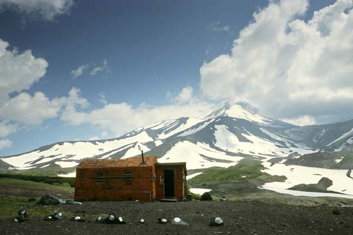
 Seen from base camp.
 Avachinsky Summit.
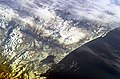 Avachinsky (centre, nearest coast) from space.
 Astronaut photograph highlighting the summit crater and snow-covered slopes of the Avachinsky.


Recorded history
In his Journal of Captain Cook's Last Voyage, John Ledyard records the eruption of Avachinsky on June 15, 1779. He refers to Koryaksky and Avachinsky as Peter and Paul.
On the 15th it continued calm until noon when it clouded up and became very black and dark: the two mountains Peter and Paul were covered with the atmosphere near half way from their summits down, and at two o'clock we had again a small shock of an earthquake, and heard a hollow rumbling noise in the air, and the atmosphere continuing to condense, it became almost as dark as night, and the face of heaven looked very wild: we singled the stops of the sheet-anchor and eased the ship aloft at all the portentous appearances. Between three and four the mountain Paul exploded with a tremendous shock that convulsed everything around us: The report that attended the explosion was very loud at first, but gradually decreased until it subsided to a sound like that of grumbling distant thunder.[6]
Recent activity

Avachinsky has erupted at least 16 times in recorded history. Eruptions have generally been explosive, and pyroclastic flows and lahars have tended to be directed to the south west by the breached caldera. The most recent large eruption (VEI=4) occurred in 1945, when about 0.25 km3 (0.060 cu mi) of magma was ejected. The volcano has since had small eruptions in 1991 and 2001.
The volcano continues to experience frequent earthquakes, and many fumaroles exist near the summit. The temperature of gases emitted at these fumaroles has been measured at over 400 °C (752 °F). In light of its proximity to Petropavlovsk-Kamchatsky, Avachinsky was designated a Decade Volcano in 1996 as part of the United Nations' International Decade for Natural Disaster Reduction, together with the nearby Koryaksky volcano.
See also
References
- "Avachinsky". Global Volcanism Program. Smithsonian Institution. Retrieved 2010-03-05.
- Avachinsky volcano on VolcanoDiscovery
- Droznin, D.; Levin, V.; Park, J.; Gordeev, E. (2002), "Detailed Mapping of Seismic Anisotropy Indicators in Southeastern Kamchatka", American Geophysical Union, Fall Meeting 2002.
- Levin, V.; Park, J.; Gordeev, E.; Droznin, D. (2002), "Complex Anisotropic Structure of the Mantle Wedge Beneath Kamchatka Volcanoes", American Geophysical Union, Fall Meeting 2002, vol. 2002, Bibcode:2002AGUFM.T21C1099L.
- Taran, Y. A.; Connor, C. B.; Shapar, V. N.; Ovsyannikov, A. A.; Bilichenko, A. A. (1997), "Fumarolic activity of Avachinsky and Koryaksky volcanoes, Kamchatka, from 1993 to 1994", Bulletin of Volcanology, 58 (6): 441–448, Bibcode:1997BVol...58..441T, doi:10.1007/s004450050152, S2CID 51397641.
- Zug, James, ed. (2005), The Last Voyage of Captain Cook: The Collected Writings of John Ledyard, Washington, DC: National Geographic Society, p. 115, ISBN 0-7922-9347-9.
External links
На других языках
[de] Awatschinskaja Sopka
Die Awatschinskaja Sopka (russisch Авачинская сопка; auch Gorjelaja Sopka, Awatschinski oder Awatscha; russisch Авачинский, Авача) ist ein aktiver Schichtvulkan auf der Halbinsel Kamtschatka im äußersten Osten Russlands.- [en] Avachinsky
[es] Avachinsky
El Aváchinski, también llamado Avacha, Aváchinskaia sopka, Awatscha, Awatschinskij, Gorélaia sopka, Monastyr, Saria o también Suachu,[1] en ruso Авáчинская сóпка, es un volcán de Rusia situado en el sur de la península de Kamchatka, en el krai homónimo.[2][fr] Avatchinski
L'Avatchinski, appelé également Avatcha[3], Gorelaïa sopka, Monastyr, Saria ou encore Souatchou[4], en russe Avatchinskaïa sopka (Авачинская сопка), est un volcan actif de Russie situé dans le sud de la péninsule du Kamtchatka dans le kraï du même nom[2].[it] Avačinskij
L'Avačinskij, detto anche Avača, Avačinskaja sopka, Gorelaja sopka, Monastyr, Saria o ancora Suachu[1], in russo Авачинская сопка, è uno stratovulcano della Russia posto nel sud della penisola della Kamčatka[2].[ru] Авачинская Сопка
Ава́чинская Со́пка[2][3][4], Ава́чинская со́пка[5] (Ава́ча), Авачинский[6], Авач-гора[7], Горелая сопка[8] — действующий вулкан на Камчатке, в южной части Восточного хребта, к северу от Петропавловска-Камчатского, в междуречье рек Авачи и Налычева. Относится к вулканам типа Сомма-Везувий[9].Другой контент может иметь иную лицензию. Перед использованием материалов сайта WikiSort.org внимательно изучите правила лицензирования конкретных элементов наполнения сайта.
WikiSort.org - проект по пересортировке и дополнению контента Википедии