geo.wikisort.org - Mountains
Ulawun is a basaltic and andesitic stratovolcano in West New Britain Province, on the island of New Britain in Papua New Guinea.
This article includes a list of references, related reading or external links, but its sources remain unclear because it lacks inline citations. (August 2019) |
| Ulawun | |
|---|---|
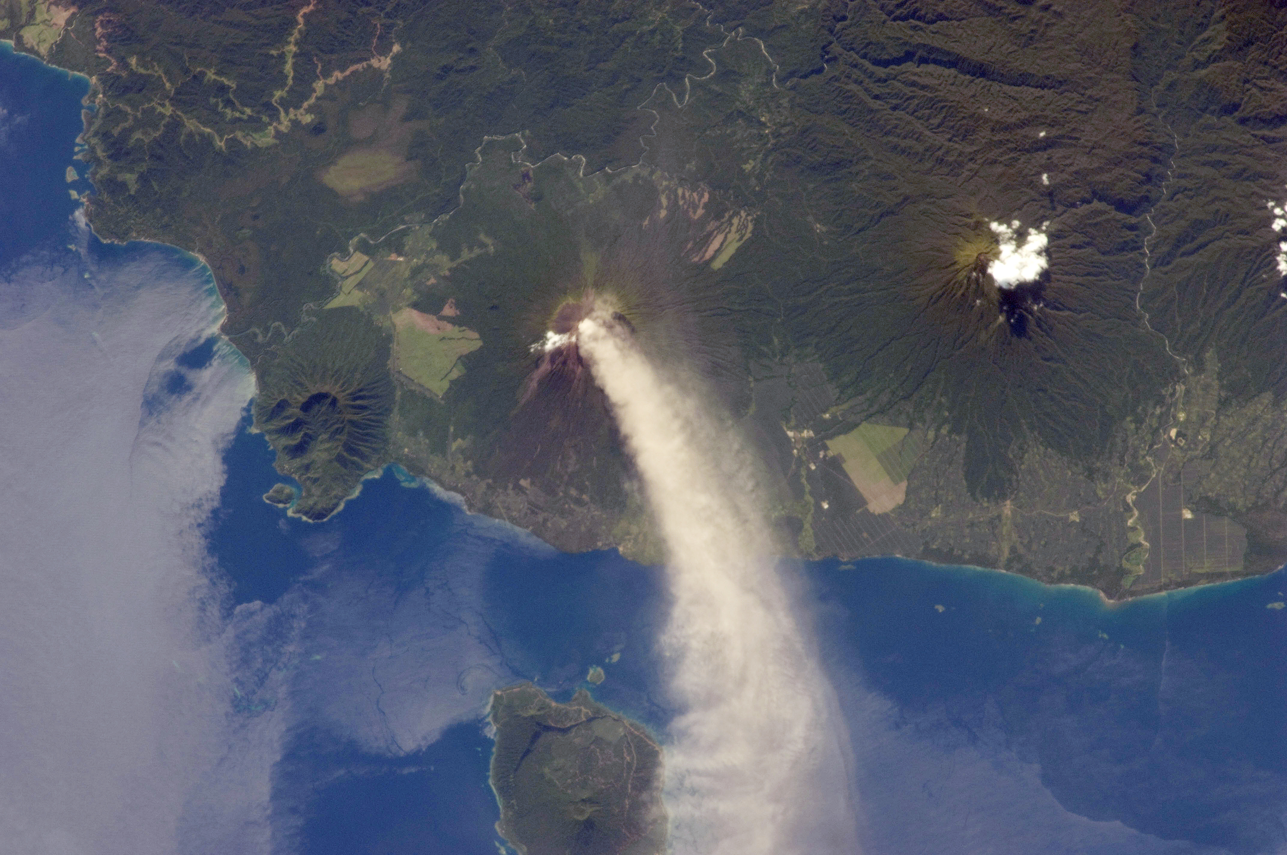
 Ulawun issuing passive steaming | |
| Highest point | |
| Elevation | 2,334 m (7,657 ft)[1] |
| Prominence | 2,334 m (7,657 ft) |
| Listing | Ultra |
| Coordinates | 5°03′00″S 151°20′00″E |
| Geography | |
 Ulawun Papua New Guinea | |
| Location | West New Britain, Papua New Guinea |
| Geology | |
| Mountain type | Stratovolcano |
| Volcanic arc/belt | Bismarck volcanic arc |
| Last eruption | 2019 |
About 130 km (81 mi) southwest of the township of Rabaul, Ulawun is the highest mountain in New Britain and the second in the Bismarck Archipelago at 2,334 metres (7,657 ft), and one of the most active volcanoes in Papua New Guinea. A total of 22 recorded eruptions have occurred since the 18th century; the first, in 1700, was recorded by William Dampier. Several thousand people live near the volcano. Because of its eruptive history and proximity to populated areas, Ulawun has been deemed one of the Decade Volcanoes.
Recent activity
The last few years have seen almost constant activity at Ulawun, with frequent small explosions, and have caused great damage and loss of life. the New Britain Highway in three different locations.[2]
Volcanoes in Papua New Guinea are some of the world's most prolific sources of sulphur dioxide. Recent studies have shown that Ulawun alone releases about 7 kg/s of SO2, which is about 2% of the global total of SO2 emissions into the atmosphere.
Ulawun has been named one of the Decade Volcanoes, 16 volcanoes identified as being worthy of particular study in light of their history of large, destructive eruptions and their proximity to populated areas. By Abubakr Sattar
View

See also
- List of volcanoes in Papua New Guinea
- List of ultras of Oceania
References
- "Ulawun". Global Volcanism Program. Smithsonian Institution. Retrieved 2020-03-25.
- Shelton, Tracey; Graue, Catherine (2019-06-28). "Papua New Guinea's Mount Ulawun volcano erupts and sends thousands of residents fleeing". ABC News. Australian Broadcasting Corporation. Retrieved 2019-06-29.
- McGonigle A.J.S., Oppenheimer C., Tsanev V.I. et al. (2004), Sulphur dioxide fluxes from Papua New Guinea's volcanoes, Geophysical Research Letters, v. 31, issue 8
- Johnson, RW, Davies, RA and White, AJR (1972) Ulawun Volcano, New Britain. Canberra, Department of National Development, Bureau of Mineral Resources, Geology and Geophysics Bulletin 142, PNG 5.
External links
- Information from the Papua New Guinea Geological Survey
- "Mount Ulawun, Papua New Guinea" on Peakbagger
На других языках
[de] Ulawun
Der Ulawun (in der deutschen Kolonialzeit Vater, englisch auch: The Father, bzw. Ulawon, Uluwun oder Vatr) ist ein Vulkan auf der zu Papua-Neuguinea gehörenden Insel Neubritannien. Mit einer Höhe von 2334 m ist er der höchste Berg der Insel.[1]- [en] Ulawun
[fr] Ulawun
L'Ulawun, également appelé The Father, Ulawon, Uluwun, Vatr[1] ou encore North Son, est un volcan de Papouasie-Nouvelle-Guinée situé dans l'île de Nouvelle-Bretagne[2].[it] Vulcano Ulawun
Il vulcano Ulawun, o Ulawan è uno tra i più pericolosi vulcani al mondo (si trova al 12º posto). Si trova in Papua Nuova Guinea nella Nuova Britannia. Dal 1700 ad oggi sono state registrate decine di eruzioni; la più recente è stata registrata nel 2019.[ru] Улавун
Улавун (англ. Ulawun) — действующий базальтовый и андезитовый стратовулкан, расположенный на острове Новая Британия (Папуа — Новая Гвинея), примерно в 130 км к юго-западу от города Рабаул. Высота вулкана составляет 2334 м, что делает его высшей точкой архипелага Бисмарка. Значительная часть покрыта растительностью, тем не менее на высоте свыше 1000 м она отсутствует[2]. Второстепенные вулканические конусы находятся на северо-западной и восточной стороне.Другой контент может иметь иную лицензию. Перед использованием материалов сайта WikiSort.org внимательно изучите правила лицензирования конкретных элементов наполнения сайта.
WikiSort.org - проект по пересортировке и дополнению контента Википедии