geo.wikisort.org - Mountains
Sakurajima (Japanese: 桜島, literally "Cherry Blossom Island") is an active stratovolcano, formerly an island and now a peninsula, in Kagoshima Prefecture in Kyushu, Japan.[2] The lava flows of the 1914 eruption connected it with the Ōsumi Peninsula.[3] It is the most active volcano in Japan.[4]
| Sakurajima | |
|---|---|
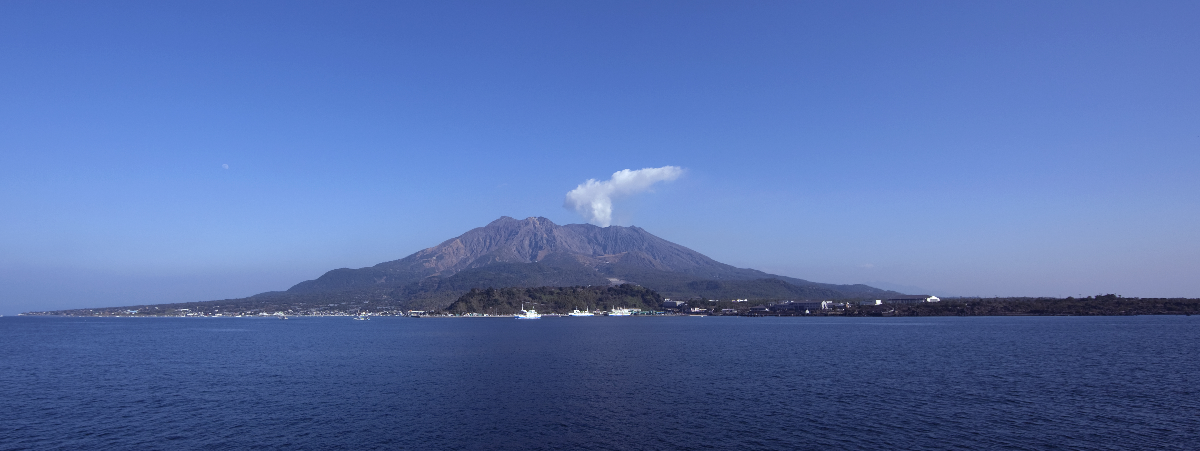 View of Sakurajima from mainland Kagoshima, 2009 | |
| Highest point | |
| Elevation | 1,117 m (3,665 ft) |
| Coordinates | 31°34′50″N 130°39′29″E |
| Geography | |
 Sakurajima Kagoshima Prefecture, Japan Sakurajima Sakurajima (Kagoshima Prefecture) | |
| Geology | |
| Mountain type | Somma-stratovolcano |
| Last eruption | 1955 to 2022 (Ongoing)[1] |
As of April 2021, the volcanic activity still continues,[5] dropping volcanic ash on the surroundings. Earlier eruptions built the white sand highlands in the region. On September 13, 2016, a team of experts from Bristol University and the Sakurajima Volcano Research Centre in Japan suggested that the volcano could have a major eruption within 30 years; since then two eruptions have occurred.[6]
Sakurajima is a stratovolcano. Its summit has three peaks, Kita-dake (northern peak), Naka-dake (central peak) and Minami-dake (southern peak) which is active now.
Kita-dake is Sakurajima's highest peak, rising to 1,117 m (3,665 ft) above sea level. The mountain is in a part of Kagoshima Bay known as Kinkō-wan. The former island is part of the city of Kagoshima.[7] The surface of this volcanic peninsula is about 77 km2 (30 sq mi).
History
Geological history

Sakurajima is in the 25 km (15 mi)-wide Aira caldera, which formed in an enormous "blow-out-and-cave-in" eruption around 22,000 years ago.[8] Several hundred cubic kilometres of ash and pumice were ejected, causing the magma chamber underneath the erupting vents to collapse. The resulting caldera is over 20 km (12 mi) across. Tephra fell as far as 1,000 km (620 mi) from the volcano. Sakurajima is a modern active vent of the same Aira caldera volcano.
Sakurajima was formed by later activity within the caldera, beginning about 13,000 years ago.[9] It is about 8 km (5 mi) south of the centre of the caldera. Its first eruption in recorded history was in 963 AD.[10] Most of its eruptions are strombolian,[10] affecting only the summit areas, but larger plinian eruptions have occurred in 1471–1476, 1779–1782 and 1914.[11]
Volcanic activity at Kita-dake ended around 4,900 years ago: later eruptions have been centered on Minami-dake.[12] Since 2006, activity has centred on Showa crater, to the east of the summit of Minami-dake.[13]
1914 eruption
| Start date | January 11, 1914 |
|---|---|
| Type | Peléan |
| VEI | 4 |
| Impact | Pre-eruption earthquakes killed at least 35 people and an additional 23 people died;[14] caused an evacuation and significant changes to the local topography. |

The 1914 eruption began on January 11 and was the most powerful in twentieth-century Japan. The volcano had been dormant for over a century until 1914.[8] Almost all residents had left the island in the previous days; several large earthquakes had warned them that an eruption was imminent. Initially, the eruption was very explosive, generating eruption columns and pyroclastic flows, but after a very large earthquake on January 12, and another the day after, it became effusive, generating a large lava flow.[8] The January 12 earthquake killed 35, and in total, 58 people died.[14][8] Lava flows filled the narrow strait between the island and the mainland, turning it into a peninsula. Lava flows are rare in Japan—because the silica content of the magmas is high, explosive eruptions are far more common[15]—but the lava flows at Sakurajima continued for months.[8] The island grew, engulfing several smaller islands nearby, and eventually became connected to the mainland by a narrow isthmus. Parts of Kagoshima Bay became significantly shallower, and it made tides higher.[8]
During the last stages of the eruption, emptying of the underlying magma chamber sank the centre of the Aira Caldera by about 60 cm (24 in).[8] This showed that Sakurajima draws its magma from the same magma reservoir that fed the ancient caldera-forming eruption.[8] The eruption partly inspired a 1914 movie, The Wrath of the Gods, centering on a family curse that ostensibly causes the eruption.
Recent activity


Sakurajima's activity became more prominent in 1955, and the volcano has been erupting almost constantly ever since. Thousands of small explosions happen each year, throwing ash to heights of up to a few kilometers above the mountain. The Sakurajima Volcano Observatory was set up in 1960 to monitor these eruptions.[10]
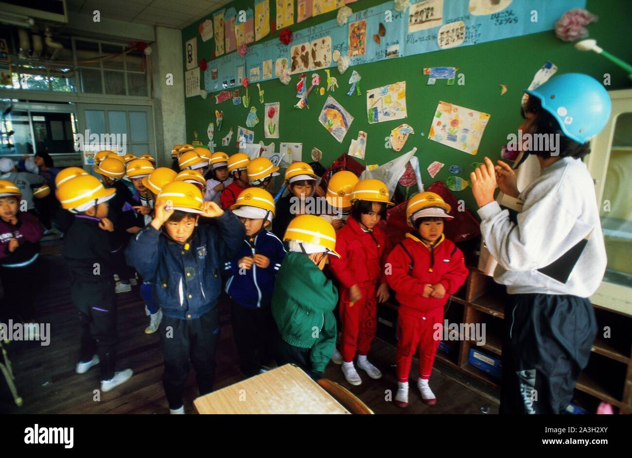
Monitoring of the volcano and predictions of large eruptions are particularly important because it is in a densely populated area, with the city of Kagoshima's 680,000 residents just a few kilometers from the volcano. The city conducts regular evacuation drills, and a number of shelters have been built where people can take refuge from falling volcanic debris.[16]
In light of the dangers it presents to nearby populations, Sakurajima was designated a Decade Volcano in 1991, identifying it as worthy of particular study as part of the United Nations' International Decade for Natural Disaster Reduction.[17]
Sakurajima is part of the Kirishima-Yaku National Park, and its lava flows are a major tourist attraction. The area around Sakurajima contains several hot spring resorts. One of the main agricultural products of Sakurajima is a huge basketball-sized white radish (Sakurajima daikon).[18]
On March 10, 2009, Sakurajima erupted, sending debris up to 2 km (1.2 mi). An eruption had been expected following a series of smaller explosions over the weekend. It is not thought there was any damage caused.[19]
An eruption occurred from the Minami-dake summit crater at 5:38 on Sunday, August 9, 2010, sending debris up to 5000 m (16,000 ft).[20]
In 2011 and 2012, Sakurajima experienced several significant eruptions; volcanic activity continued into 2013.[21] Photographer Martin Rietze captured a rare picture of lightning within the ash plume in January 2013 during a magma ejection, which was a NASA astronomy pic of the day in March 2013.[22]
On August 18, 2013, the volcano erupted from Showa crater and produced its highest recorded plume of ash since 2006, rising 5,000 metres high and causing darkness and significant ash falls on the central part of Kagoshima city. The eruption occurred at 16:31 and was the 500th eruption of the year.[23]
In August 2015, Japan's meteorological agency issued a level 4 emergency warning, which urges residents to prepare to evacuate.[24] Scientists warned that a major eruption could soon take place at the volcano;[25] it eventually did erupt around 20:00 on February 5, 2016.[26]
After a long pause of eruptions at the vent, the eruptions abruptly stopped there and returned to the Showa crater, on April 4, 2016, some 8–9 days preceding major earthquakes on the Median Tectonic Line near Kumamoto, Japan.[27] Then, three months later, on July 26, it spewed volcanic ash 5,000 m (16,000 ft) into the air.[28]
On October 3, 2020, at 07:35 UTC, the volcano erupted once again, this time from the Aira caldera. A volcanic ash advisory for aviation was issued by the Volcanic Ash Advisory Center Tokyo (VAAC) at 07:43 UTC, showing the ash cloud to be stationary and reaching FL100 (10,000 feet).[29]
On July 24, 2022, at 20:05 JST, an explosive eruption occurred at the summit crater of the volcano, and cinders scattered up to 2.5 km from the crater.[30][31] Following this eruption, at 20:50 JST, the Japan Meteorological Agency raised the eruption alert level from Level 3 to Level 5, the highest level, and urged maximum precaution and evacuation.[30] This was the first time an eruption alert level 5 has been issued for Sakurajima.[32]
Timeline
 Eruption in 1914
 Sakurajima eruption in 1974
 Space radar image of Sakurajima in 1994
 2004
2004 2009
2009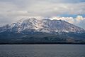 2010
2010 Eruption on 2013-09-23
 A print of Sakurajima by Hiroshige
 Sakurajima from a ferry in Kagoshima Bay, 2019-07-01
 Seen from an aircraft in 2009
 Satellite view in January 2020
 April 2021


Culture
Sakurajima is the title of a 1946 short story, written by the Japanese writer Haruo Umezaki, about a disillusioned Navy officer stationed on the volcano island towards the end of World War II as American air force planes bomb Japan. The story is based on Umezaki's own experience; he was stationed in a military cipher base in the nearby Prefecture city of Kagoshima.
Sakurajima was also the name of Japanese singer Tsuyoshi Nagabuchi's song. In 2004, Nagabuchi held an all-night-concert at a quarry of Sakurajima that attracted an audience of 75,000. After the concert, a statue showing Nagabuchi screaming with a guitar was installed on the site of the concert.[33]
See also
Notes
- "Sakurajima volcano". 31 Jan 2019.
- Nussbaum, Louis-Frédéric. (2005). "Sakurajima" in Japan Encyclopedia, p. 814; see photo, caption -- Kagoshima after Sakurashima eruption, Illustrated London News. January 1914.
- Davison C (1916-09-21). "The Sakura-Jima Eruption of January, 1914". Nature. 98 (2447): 57–58. Bibcode:1916Natur..98...57D. doi:10.1038/098057b0. S2CID 3964260.
- "Sakurajima, Japan's Most Active Volcano". nippon.com. Nippon Communications Foundation. May 16, 2018. Retrieved August 2, 2018.
- "Sakurajima Volcano Volcanic Ash Advisory: VA AT 20210405/0420Z FL050 EXTD NE OBS VA DTG: 05/0420Z to 5000 ft (1500 m)". volcanodiscovery.com. Retrieved 6 April 2021.
- McCurry, Justin (13 September 2016). "New data points to major eruption of Japanese volcano". the Guardian. Retrieved 17 April 2018.
- Nussbaum, "Kagoshima prefecture" at p. 447.
- "The 1914 Sakurajima explosion at Volcanoworld". Archived from the original on 2008-06-16. Retrieved 2007-08-03.
- "Sakurajima at Activolcan.info" (in French). Retrieved 2007-08-03.
- "Sakura-jima, Japan". VolcanoWorld. Oregon State University. Archived from the original on 2008-08-01. Retrieved 2008-10-12.
- "Sakurajima at the Earthquake Research Institute, University of Tokyo". Archived from the original on 2008-02-14. Retrieved 2007-08-03.
- "Aira: Eruptive History". Global Volcanism Program. Smithsonian Institution. Retrieved 2007-08-04.
- Iguchi, Masato (20 July 2013). "Forecasting volcanic activity of Sakurajima" (PDF). Proceedings of IAVCEI 2013 Scientific Assembly. Archived from the original (PDF) on 20 October 2013. Retrieved 18 August 2013.
- "Japan's Sakurajima volcano due for major eruption within 30 years, say scientists". BBC News. 14 September 2016. Retrieved 24 February 2017.
- "Japanese Volcanoes at the Northern Illinois University". Archived from the original on 2010-08-19. Retrieved 2007-08-06.
- "Reuters report on Sakurajima explosion, June 5th 2006". Archived from the original on 2007-09-28. Retrieved 2007-08-06.
- "Decade Volcano Sakurajima at the Earthquake Research Institute". Archived from the original on 2007-08-19. Retrieved 2007-08-06.
- "Touristic information on synapse.ne.jp". Retrieved 2007-08-06.
- "Japan's Sakurajima volcano erupts". March 10, 2009. Retrieved March 16, 2012.
- "桜島が噴火 噴煙が火口上5000mに上昇 噴煙量は多量(ウェザーニュース)". Yahoo!ニュース (in Japanese). Retrieved 2020-08-09.
- "Volcanic activity world-wide 16 November 2012: Ruapehu, Paluweh, Michael, Kilauea, Fuego, Santiaguito, Nevado del Ruiz, Reventador, Sakurajima, Mammoth Mountain (Long Valley),Ambrym, Nyiragongo". www.volcanodiscovery.com. Retrieved 17 April 2018.
- Nemiroff, R.; Bonnell, J., eds. (11 March 2013). "Sakurajima Volcano with Lightning". Astronomy Picture of the Day. NASA.
- "Sakurajima spews its highest volcanic column ever at 5,000 meters". Asahi Shimbun. 18 August 2013. Archived from the original on 4 March 2016. Retrieved 18 August 2013.
- "Volcano alerts issued in Ecuador, Japan". 15 August 2015. Retrieved 16 August 2015.
- Klemetti, Erik. "Sakurajima in Japan Might Be Headed Towards a Large Eruption". Wired. Retrieved 17 April 2018.
- "Sakurajima volcano in Japan erupts". The Guardian. Associated Press. 5 February 2016. Retrieved 5 February 2016.
- "Volcanic activity worldwide 4 Apr 2016: Popocatépetl volcano, Bromo, Turrialba, Sangay, Sakurajima,..." www.volcanodiscovery.com. Retrieved 17 April 2018.
- "Kagoshima's Sakurajima volcano erupts, spews plume 5,000 meters up". 26 July 2016. Retrieved 17 April 2018 – via Japan Times Online.
- "Sakurajima Volcano Volcanic Ash Advisory: ERUPTED AT 20201003/0735Z FL100 STNR OBS VA DTG: 03/0730Z". www.volcanodiscovery.com. Retrieved 2020-10-03.
- "桜島で噴火 噴火警戒レベル5に引き上げ 33世帯に避難指示 | NHK". NHK (in Japanese). Retrieved 2022-07-24.
- "MBCニュース | 桜島で噴火 噴石が東方向に2.4キロ飛ぶ". MBC. Retrieved 2022-07-24.
- "桜島で噴火が発生 気象庁が噴火速報を発表 火口上300mで雲に入る". WeatherNews (in Japanese). Retrieved 2022-07-24.
- Matthew Holmes (2012-04-08). "Moving and shaking on Sakurajima". The Japan Times.
References
- Townley, S.D. (1915). "Seismographs at the Panama-Pacific Exposition," Bulletin of the Seismological Society of America. Stanford, California: Seismological Society of America. OCLC 1604335
- Teikoku's Complete Atlas of Japan, Teikoku-Shoin Co., Ltd. Tokyo 1990
Further reading
- Aramaki S. (1984), Formation of the Aira Caldera, Southern Kyūshū, ~22,000 years ago, Journal of Geophysical Research, v. 89, issue B10, p. 8485.
- Guide-books of the Excursions: Pan-Pacific Science Congress, 1926, Japan. Tokyo: Tokyo Printing Co. OCLC 7028702
- Johnson, H & Kuwahara, S (2016), Sakurajima: Maintaining an island essence, Shima: The International Journal of Research into Island Cultures, vol. 10, no.1, pp. 48–66.
External links
- Sakurajima: National catalogue of the active volcanoes in Japan - Japan Meteorological Agency
- Sakurajima Volcano Research Center - Kyoto University
- Aira / Sakurajima, Global Volcanic Program
- Footage of the March 2009 eruption - BBC
- Schoolchildren in Kagoshima wearing helmets to protect against stones thrown out by the nearby Sakurajima volcano (which is in background)
- Schoolchildren and their teacher wearing helmets
- Google Earth air view
- Google Earth ground view approaching Sakurajima from the mainland
- Smithsonian Institution's Global Volcanism Program (GVP) (entry for Aira /Sakurajima)
На других языках
[de] Sakurajima
Der aktive Vulkan Sakurajima (japanisch 桜島 „Kirschblüteninsel“) liegt in der Präfektur Kagoshima auf Kyūshū in Japan. Er gehört zum Verwaltungsgebiet der Stadt Kagoshima und entstand vor etwa 13.000 Jahren als Vulkaninsel im Süden der Aira-Caldera, die weitere rund 9.000 Jahre zuvor entstanden war und den Nordteil der Kagoshima-Bucht bildet.- [en] Sakurajima
[es] Sakurajima
El Sakurajima (桜島, Sakurajima?) es un volcán (estratovolcán) activo y antigua isla (actualmente está unida a la de Kyūshū) de Japón, situado en el sur de la isla de Kyūshū, en la prefectura de Kagoshima. Se encuentra en la parte de la bahía de Kagoshima conocida como bahía de Nishikie.[1] Hasta 1914, Sakurajima era una isla, pero debido a una gran erupción, la enorme cantidad de lava que soltó se solidificó y unió la isla con la península de Ōsumi.[2] La actividad volcánica todavía continúa: aún emite grandes coladas de ceniza volcánica.[fr] Sakurajima
Le Sakurajima (桜島, Sakura-jima?) est un volcan du Japon situé dans le sud de l'île de Kyūshū. C'est un des volcans les plus actifs du Japon. Lors de la puissante éruption de 1914, le volcan a cessé d'être une île lorsque de la lave a comblé le détroit qui la séparait de l'île de Kyūshū. Le risque humain est un des plus élevés au Japon car l'activité éruptive du Sakurajima est intense, explosive et le volcan se trouve au milieu de la baie de Kagoshima. Ces conditions font peser un risque constant de nuées ardentes et de tsunamis sur la population qui vit à proximité, notamment la ville de Kagoshima (environ 600 000 habitants) distante de huit kilomètres à vol d'oiseau.[it] Sakurajima
Il Sakurajima (桜島?) è un vulcano attivo, nonché isola omonima (ora unita alla terraferma) nella prefettura di Kagoshima, nel Giappone sud-occidentale.[ru] Сакурадзима
Сакурадзима (яп. 桜島 Сакурадзима, букв. «остров сакуры») — действующий стратовулкан, расположенный на полуострове Осуми острова Кюсю в японской префектуре Кагосима. До 1914 года Сакурадзима была отдельным островом, но в результате извержения она была соединена потоками лавы с полуостровом Осуми. Высота вулкана — 1117 метров, а площадь — около 77 км². У Сакурадзимы три вершины: северный пик Китадакэ (яп. 北岳, 1117 м), центральный Накадакэ (яп. 中岳, 1060 м) и южный Минамидакэ (яп. 南岳, 1040 м).Другой контент может иметь иную лицензию. Перед использованием материалов сайта WikiSort.org внимательно изучите правила лицензирования конкретных элементов наполнения сайта.
WikiSort.org - проект по пересортировке и дополнению контента Википедии