geo.wikisort.org - Mountains
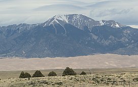
Mount Herard is a high and prominent mountain summit in the Sangre de Cristo Range of the Rocky Mountains of North America. The 13,345-foot (4,068 m) thirteener is located in the Sangre de Cristo Wilderness of Great Sand Dunes National Preserve, 15.0 miles (24.1 km) southeast (bearing 132°) of the Town of Crestone in Saguache County, Colorado, United States.[1][2][3]
| Mount Herard | |
|---|---|
 Mount Herard as seen from the Great Sand Dunes | |
| Highest point | |
| Elevation | 13,345 ft (4,068 m)[1][2] |
| Prominence | 2,040 ft (622 m)[2] |
| Isolation | 4.63 mi (7.45 km)[2] |
| Listing | |
| Coordinates | 37°50′57″N 105°29′40″W[3] |
| Geography | |
 Mount Herard Colorado | |
| Location | Great Sand Dunes National Park and Preserve, Saguache County, Colorado, United States[3] |
| Parent range | Sangre de Cristo Range[2] |
| Topo map | USGS 7.5' topographic map Medano Pass, Colorado[3] |
Mountain
Originally called Medano Peak, the mountain with seven separate summits was renamed Mount Seven at the request of the Colorado Mountain Club in 1970.[3] In 1984 the mountain's name was changed to honor Ulysses Herard who homesteaded on its slopes in 1876.[3]
Historical names
- Herard Peak
- Medano Peak [3]
- Mount Cleveland
- Mount Herard – 1984 [3]
- Mount Seven – 1970 [3]
- XL Mountain
See also
References
- The elevation of Mount Herard includes an adjustment of +1.640 m (+5.38 ft) from NGVD 29 to NAVD 88.
- "Mount Herard, Colorado". Peakbagger.com. Retrieved October 20, 2014.
- "Mount Herard". Geographic Names Information System. United States Geological Survey. Retrieved October 20, 2014.
External links
На других языках
- [en] Mount Herard
[fr] Mont Herard
Le mont Herard, en anglais Mount Herard, est un sommet montagneux américain dans le comté de Saguache, au Colorado. Il culmine à 4 069 mètres d'altitude dans le chaînon Sangre de Cristo. Il est protégé au sein de la réserve nationale des Great Sand Dunes et de la Sangre de Cristo Wilderness.Текст в блоке "Читать" взят с сайта "Википедия" и доступен по лицензии Creative Commons Attribution-ShareAlike; в отдельных случаях могут действовать дополнительные условия.
Другой контент может иметь иную лицензию. Перед использованием материалов сайта WikiSort.org внимательно изучите правила лицензирования конкретных элементов наполнения сайта.
Другой контент может иметь иную лицензию. Перед использованием материалов сайта WikiSort.org внимательно изучите правила лицензирования конкретных элементов наполнения сайта.
2019-2025
WikiSort.org - проект по пересортировке и дополнению контента Википедии
WikiSort.org - проект по пересортировке и дополнению контента Википедии
