geo.wikisort.org - Mountains
Cirque Mountain is a 13,686-foot-elevation (4,171 meter) mountain summit located in Ouray County of southwest Colorado, United States.[4] It is situated six miles west of the community of Ouray, above the north side of Yankee Boy Basin, on land managed by Uncompahgre National Forest. It is part of the Sneffels Range which is a subset of the San Juan Mountains, which in turn is part of the Rocky Mountains. Cirque ranks as the 155th-highest peak in Colorado,[3] and the ninth-highest in the Sneffels Range.[1] It is west of the Continental Divide, 1.12 mile east of Mount Sneffels, and 0.59 mile west of Teakettle Mountain, which is the nearest higher neighbor.[1] Topographic relief is significant as the north aspect rises 3,000 feet (914 meters) above Blaine Basin in one mile, and the south aspect rises over 2,000 feet above Yankee Boy Basin in less than one mile. These basins are cirques which were carved by ancient glaciers.[5] The mountain's name has been officially adopted by the United States Board on Geographic Names.[4]
| Cirque Mountain | |
|---|---|
 Cirque Mountain (left), west aspect. (Teakettle Mtn upper right, from Mt. Sneffels) | |
| Highest point | |
| Elevation | 13,686 ft (4,171 m)[1][2] |
| Prominence | 526 ft (160 m)[1] |
| Parent peak | Teakettle Mountain (13,819 ft)[3] |
| Isolation | 0.57 mi (0.92 km)[3] |
| Coordinates | 38°00′14″N 107°46′18″W[4] |
| Naming | |
| Etymology | cirque |
| Geography | |
 Cirque Mountain Location in Colorado  Cirque Mountain Cirque Mountain (the United States) | |
| Location | Ouray County Colorado, US |
| Parent range | Rocky Mountains San Juan Mountains Sneffels Range[1] |
| Topo map | USGS Mount Sneffels |
| Geology | |
| Type of rock | Extrusive rock |
| Climbing | |
| Easiest route | class 2+[3] Southwest Ridge |
Climate
According to the Köppen climate classification system, Cirque Mountain is located in an alpine subarctic climate zone with long, cold, snowy winters, and cool to warm summers.[6] Due to its altitude, it receives precipitation all year, as snow in winter, and as thunderstorms in summer, with a dry period in late spring. Precipitation runoff from the mountain drains into tributaries of the Uncompahgre River.
Gallery
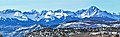 Sneffels Range from the north. Left to right: Whitehouse Mountain, Mount Ridgway, Teakettle Mountain, Cirque Mountain (centered), Mount Sneffels.
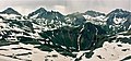 Left to rightː Gilpin Peak, Mt. Sneffels, Cirque Mountain, Teakettle Mountain.
(Stony Mountain below Cirque). Looking north. Cirque Mountain centered, Teakettle (left), Blaine Peak (right). From NW.


See also
- Mountains of Ouray County, Colorado
References
- "Cirque Mountain, Colorado". Peakbagger.com.
- Mike Garratt, Bob Martin, Colorado's High Thirteeners: A Climbing and Hiking Guide, 1992, Johnson Books, ISBN 9780917895395, page 161.
- "Cirque Mountain - 13,686' CO". listsofjohn.com. Retrieved 2021-07-05.
- "Cirque Mountain". Geographic Names Information System. United States Geological Survey, United States Department of the Interior. Retrieved 2021-07-05.
- Ralph Lee Hopkins, Lindy Birkel Hopkins, 2000, Hiking Colorado's Geology, The Mountaineers Books, ISBN 9780898867084, page 155.
- Peel, M. C.; Finlayson, B. L.; McMahon, T. A. (2007). "Updated world map of the Köppen−Geiger climate classification". Hydrol. Earth Syst. Sci. 11. ISSN 1027-5606.
External links
- Weather forecast: Cirque Mountain
Другой контент может иметь иную лицензию. Перед использованием материалов сайта WikiSort.org внимательно изучите правила лицензирования конкретных элементов наполнения сайта.
WikiSort.org - проект по пересортировке и дополнению контента Википедии