geo.wikisort.org - Mountains
Mount Ridgway is a 13,468-foot-elevation (4,105 meter) mountain summit located in Ouray County of southwest Colorado, United States.[3] It is situated five miles west of the community of Ouray, on land managed by Uncompahgre National Forest. It is part of the Sneffels Range which is a subset of the San Juan Mountains, which in turn is part of the Rocky Mountains. It is west of the Continental Divide, 2.2 miles east-northeast of Mount Sneffels, and 0.95 miles southwest of Whitehouse Mountain, which is the nearest higher neighbor.[1] Topographic relief is significant as the west aspect rises 3,000 feet (914 meters) above Blaine Basin in one mile.
| Mount Ridgway | |
|---|---|
 North aspect | |
| Highest point | |
| Elevation | 13,468 ft (4,105 m)[1] |
| Prominence | 428 ft (130 m)[1] |
| Parent peak | Whitehouse Mountain (13,492 ft)[2] |
| Isolation | 0.94 mi (1.51 km)[2] |
| Coordinates | 38°00′49″N 107°45′11″W[3] |
| Naming | |
| Etymology | Robert M. Ridgway |
| Geography | |
 Mount Ridgway Location in Colorado  Mount Ridgway Mount Ridgway (the United States) | |
| Location | Ouray County Colorado, US |
| Parent range | Rocky Mountains San Juan Mountains Sneffels Range[1] |
| Topo map | USGS Mount Sneffels |
| Geology | |
| Type of rock | Extrusive rock |
| Climbing | |
| Easiest route | class 2 hiking[2] |
Etymology
This mountain, the nearby town of Ridgway, the Ridgway Dam, and Ridgway State Park trace their names to Denver & Rio Grande Railroad superintendent Robert Matthew Ridgway (1834–1908), who established the town in 1891.[4][5] The mountain's name has been officially adopted by the United States Board on Geographic Names.[3]
Climate
According to the Köppen climate classification system, Mount Ridgway is located in an alpine subarctic climate zone with long, cold, snowy winters, and cool to warm summers.[6] Due to its altitude, it receives precipitation all year, as snow in winter, and as thunderstorms in summer, with a dry period in late spring. Precipitation runoff from the mountain drains into tributaries of the Uncompahgre River.
Gallery
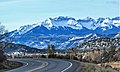 Whitehouse Mountain centered with Mt. Ridgway to immediate right, seen from Highway 550 near the town of Ridgway
 Mount Ridgway (left) and Reconnoiter Peak (right)
 Sneffels Range with Mt. Ridgway to the left


See also
- Mountains of Ouray County, Colorado
References
- "Mount Ridgway, Colorado". Peakbagger.com.
- "Ridgway, Mount - 13,468' CO". listsofjohn.com. Retrieved 2021-07-03.
- "Mount Ridgway". Geographic Names Information System. United States Geological Survey. Retrieved 2021-07-03.
- Dawson, John Frank. Place names in Colorado: why 700 communities were so named, 150 of Spanish or Indian origin. Denver, CO: The J. Frank Dawson Publishing Co. p. 43.
- Liobrary of Congress
- Peel, M. C.; Finlayson, B. L.; McMahon, T. A. (2007). "Updated world map of the Köppen−Geiger climate classification". Hydrol. Earth Syst. Sci. 11. ISSN 1027-5606.
External links
- Weather forecast: Mount Ridgway
Другой контент может иметь иную лицензию. Перед использованием материалов сайта WikiSort.org внимательно изучите правила лицензирования конкретных элементов наполнения сайта.
WikiSort.org - проект по пересортировке и дополнению контента Википедии