geo.wikisort.org - Mountains
Electric Peak is a 13,292-foot-elevation (4,051 meter) mountain summit located in San Juan County, Colorado, United States.[3] It is situated eight miles south of the community of Silverton, in the Weminuche Wilderness, on land managed by San Juan National Forest. It is part of the Needle Mountains which are a subset of the San Juan Mountains, which in turn is a subset of the Rocky Mountains. Precipitation runoff from the mountain drains into tributaries of the Animas River. The peak can be seen from U.S. Route 550 and the Durango and Silverton Narrow Gauge Railroad. Topographic relief is significant as the west aspect rises over 4,500 feet (1,370 meters) above the river and railway in approximately two miles. It is set five miles west of the Continental Divide, and one mile east of Mount Garfield. The mountain's name, which has been officially adopted by the United States Board on Geographic Names, was in use before 1906 when Henry Gannett published it in the Gazetteer of Colorado.[5]
| Electric Peak | |
|---|---|
 Northwest aspect centered (Top of Arrow Peak visible directly behind Electric. Trinity Peaks to left, Graystone Peak to right.) | |
| Highest point | |
| Elevation | 13,292 ft (4,051 m)[1] |
| Prominence | 812 ft (247 m)[1] |
| Parent peak | Graystone Peak (13,489 ft)[2] |
| Isolation | 0.58 mi (0.93 km)[2] |
| Coordinates | 37°41′56″N 107°37′02″W[3] |
| Geography | |
 Electric Peak Location in Colorado  Electric Peak Electric Peak (the United States) | |
| Location | San Juan County, Colorado, US |
| Parent range | Rocky Mountains San Juan Mountains Needle Mountains[1] |
| Topo map | USGS Storm King Peak |
| Geology | |
| Age of rock | Statherian |
| Mountain type | Intrusive |
| Type of rock | Quartzite |
| Climbing | |
| Easiest route | class 2[2] South Face[4] |
Climate
According to the Köppen climate classification system, Electric Peak is located in an alpine subarctic climate zone with very long, cold, snowy winters, and cool to warm summers.[6] Due to its altitude, it receives precipitation all year, as snow in winter, and as thunderstorms in summer, with a dry period in late spring.
Geology
Electric Peak is part of the Uncompahgre Formation, which is a sequence of quartzite and black phyllite some 8,200 feet (2,500 meters) in thickness.[7] The formation dates to the Statherian period and is interpreted as metamorphosed marine and fluvial sandstone, mudstone, and shale. The formation overlies plutons with an age of 1,707 million years.
Gallery
 Electric Peak (left), Graystone Peak, Mt. Garfield (right) viewed from Molas Lake
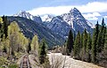 Electric Peak (left), Garfield (right) seen with Animas River from Durango and Silverton train
 Electric Peak, Graystone Peak (center), Mt. Garfield (right) from Molas Lake
 Electric Peak, Graystone Peak (center), Mt. Garfield (right)


References
- "Electric Peak, Colorado". Peakbagger.com.
- "Electric Peak - 13,292' CO". listsofjohn.com. Retrieved 2021-06-29.
- "Electric Peak". Geographic Names Information System. United States Geological Survey, United States Department of the Interior. Retrieved 2021-06-29.
- Robert F. Rosebrough, The San Juan Mountains: A Climbing & Hiking Guide, Cordillera Press, 1986, page 170.
- Henry Gannett, Gazetteer of Colorado, 1906, US Government Printing Office, page 64.
- Peel, M. C.; Finlayson, B. L.; McMahon, T. A. (2007). "Updated world map of the Köppen−Geiger climate classification". Hydrol. Earth Syst. Sci. 11. ISSN 1027-5606.
- Rob Blair, Tom Ann Casey, William H. Romme, The Western San Juan Mountains: Their Geology, Ecology, and Human History, 1996, University Press of Colorado, ISBN 9780870813788, page 350.
External links
- Weather forecast: Electric Peak
Другой контент может иметь иную лицензию. Перед использованием материалов сайта WikiSort.org внимательно изучите правила лицензирования конкретных элементов наполнения сайта.
WikiSort.org - проект по пересортировке и дополнению контента Википедии