geo.wikisort.org - Mountains Hallett Peak is a mountain summit in the northern Front Range of the Rocky Mountains of North America. The 12,720-foot (3,877 m) peak is located in the Rocky Mountain National Park Wilderness, 10.1 miles (16.2 km) southwest by west (bearing 240°) of the Town of Estes Park, Colorado, United States, on the Continental Divide between Grand and Larimer counties.[1] [2] [3] [4]
Mountain in Colorado, United States
Hallett Peak Looking west over
Dream Lake . Hallett Peak is on the left with the dramatic cliff band and prominent point.
Elevation 12,720 ft (3,877 m)[1] [2] Prominence 733 ft (223 m)[3] Isolation 1.97 mi (3.17 km)[3] Coordinates 40°18′11″N 105°41′09″W [1] Location Continental Divide in[4] Parent range Front Range Topo map USGS 7.5' topographic map[1] Easiest route hike
Mountain
Hallett Peak is on the Continental Divide, flanked by Flattop Mountain to the north and Otis Peak to the south. Just to its east lie Emerald Lake , Dream Lake , and Nymph Lake , access to which is usually from the Bear Lake Comfort Station.[5] [6]
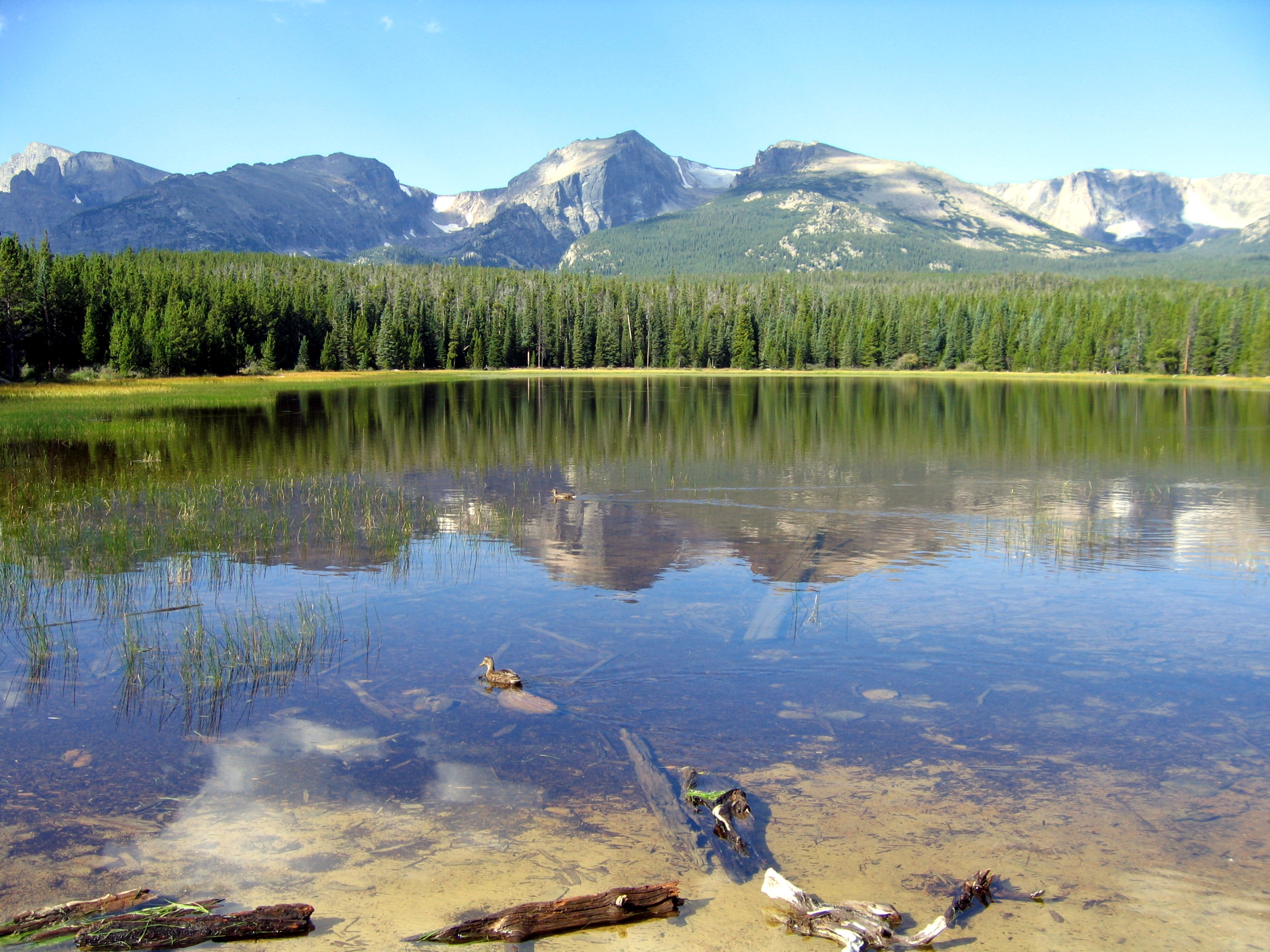
A view from Bierstadt Lake . Hallett Peak is at the center, flanked on the left by Otis Peak , with Flattop Mountain and Ptarmigan Point on the right.
The Northcutt-Carter Route of Hallett Peak is recognized in the historic climbing text Fifty Classic Climbs of North America .[5] [6]
See also
Geology portal Geography portal North America portal United States portal Colorado portal Mountains portal
References
"HALLETT TP" . NGS data sheet . U.S. National Geodetic Survey. Retrieved November 4, 2014 .The elevation of Hallett Peak includes an adjustment of +1.612 m (+5.29 ft) from NGVD 29 to NAVD 88. "Hallett Peak, Colorado" . Peakbagger.com . Retrieved November 4, 2014 ."Hallett Peak" . Geographic Names Information System . United States Geological Survey. Retrieved November 4, 2014 .Roper, Steve; Steck, Allen (1979). Fifty Classic Climbs of North America . San Francisco: Sierra Club Books. ISBN 0-87156-292-8 . Stewart M. Green Rock Climbing Colorado , Chockstone, Falcon, Helena, MO, 1995 ; ISBN 1-56044-334-0.
External links
Hallett Peak reflected in Lake Haiyaha at sunrise
Rocky Mountain National Park
Attractions
Alpine Visitor Center
Alpine Tundra Research
Beaver Meadows Visitor Center
Agnes Vaille Shelter
Dutchtown (ghost town)
Fall River Pass
Horseshoe Park
Kawuneeche Valley
Lulu City (ghost town)
Lumpy Ridge
Middle Park
Milner Pass (Continental Divide)
Moraine Park Museum and Amphitheater
Petit Grepon (spire) Upper Beaver Meadows
Wild Basin Peaks Hiking trails and
Hiking trails
Bear Lake Bierstadt Lake Continental Divide Trail
East Inlet Trail
East Longs Peak Trail
Fern Lake Trail
Flattop Mountain Trail
Lake Haiyaha Trail
Lost Lake Trail
Shadow Mountain Trail
Thunder Lake Trail-Bluebird Lake Trail
Upper Beaver Meadows
Technical climbs
Casual Route
Northcutt-Carter Route
South Face (Petit Grepon) Glaciers
Andrews Glacier
The Dove (glacier)
Mills Glacier
Moomaw Glacier
Rowe Glacier
Saint Vrain Glaciers
Taylor Glacier
Tyndall Glacier Bodies of
History
History of Rocky Mountain National Park
NRHP listings in RMNP
NRHP in Rocky Mountain NP template
Districts or areas
Cache La Poudre River Corridor National Heritage Area
Fall River Entrance Historic District
Holzwarth Historic District People
Earl of Dunraven
Elkanah Lamb
Stephen H. Long
Enos Mills
Freelan Oscar Stanley
Ute people Lodging
Grand Lake Lodge
The Stanley Hotel Natural disasters Transportation Nearby
Allenspark
Boulder
Estes Park
Grand Lake
Longmont
Lyons Geology and Additional
Rocky Mountain National Park Category
Colorado Portal
Protected areas of Colorado
Federal
State
43 Colorado State Parks
Arkansas Headwaters
Barr Lake
Boyd Lake Castlewood Canyon
Chatfield
Cherry Creek
Cheyenne Mountain
Crawford
Eldorado Canyon
Eleven Mile
Elkhead
Fishers Peak
Golden Gate Canyon
Harvey Gap
Highline Lake
Jackson Lake
James M. Robb - Colorado River
John Martin Reservoir
Lake Pueblo
Lathrop
Lone Mesa
Lory
Mancos
Mueller
Navajo
North Sterling
Paonia
Pearl Lake
Ridgway
Rifle Falls Rifle Gap
Roxborough
Spinney Mountain
St. Vrain
Stagecoach
State Forest
Staunton
Steamboat Lake
Sweetwater Lake
Sweitzer Lake
Sylvan Lake
Trinidad Lake
Vega
Yampa River 307 State Wildlife Areas
List of Colorado state wildlife areas 93 Colorado Natural Areas 26 Scenic and Historic Byways
Alpine Loop
Cache la Poudre-North Park
Collegiate Peaks
Colorado River Headwaters
Dinosaur Diamond
Flat Tops Trail
Frontier Pathways
Gold Belt Tour
Grand Mesa
Guanella Pass
Highway of Legends
Lariat Loop
Los Caminos Antiguos
Mount Evans
Pawnee Pioneer Trails
Peak to Peak
San Juan Skyway
Santa Fe Trail
Silver Thread
South Platte River Trail
Top of the Rockies
Tracks Across Borders
Trail of the Ancients
Trail Ridge Road/Beaver Meadow
Unaweep Tabeguache
West Elk Loop
Trails
28 National Recreation Trails
Apex Barr
Bear Creek Big Dry Creek Calico
Crag Crest Devils Head Fish Creek Falls Grays Peak
Greyrock Mountain
Highline Canal
Highline Loop Lake Fork Mineral Belt
Mount Evans
Mount McConnel
Petroglyph Point Platte River Greenway Poudre River Rocky Mountain Arsenal
Round Mountain
Swamp Park Two Elk Two Ponds
Vail Pass West Lost Trail Creek Wheeler Ten Mile White House Ranch 6 Regional Trails
American Discovery Trail
Colorado Trail
Great Divide Trail
Kokopelli Trail
Paradox Trail
Tabeguache Trail
Colorado Department of Natural Resources (
web )
На других языках - [en] Hallett Peak [fr] Pic Hallett Le pic Hallett (en anglais : Hallett Peak) est un sommet montagneux américain à la frontière des comtés de Grand et de Larimer, dans le Colorado. Il culmine à 3 875 mètres d'altitude dans la Front Range, protégé au sein du parc national de Rocky Mountain. Текст в блоке "Читать" взят с сайта "Википедия" и доступен по лицензии Creative Commons Attribution-ShareAlike ; в отдельных случаях могут действовать дополнительные условия. 2019-2026


 Definitions from Wiktionary
 Media from Commons
 News from Wikinews
 Quotations from Wikiquote
 Texts from Wikisource
 Textbooks from Wikibooks
 Resources from Wikiversity
