geo.wikisort.org - Mountains
Horsetooth Mountain is a mountain summit in the foothills of the Front Range of the Rocky Mountains of North America. The 7,259-foot (2,213 m) peak is located in the Horsetooth Mountain Open Space, 7.0 miles (11.2 km) west (bearing 265°) of downtown Fort Collins in Larimer County, Colorado, United States.[1][2][3][4]
| Horsetooth Mountain | |
|---|---|
 Horsetooth from Fort Collins | |
| Highest point | |
| Elevation | 7,259 ft (2,213 m)[1][2] |
| Prominence | 595 ft (181 m)[3] |
| Isolation | 3.46 mi (5.57 km)[3] |
| Coordinates | 40°32′22″N 105°11′48″W[1] |
| Geography | |
 Horsetooth Mountain Colorado | |
| Location | Larimer County, Colorado, U.S.[4] |
| Parent range | Front Range foothills[3] |
| Topo map | USGS 7.5' topographic map Horsetooth Reservoir, Colorado[1] |
| Climbing | |
| Easiest route | Scramble |
Mountain
The mountain is easily distinguishable by the large pegmatite rock formation on its summit known as Horsetooth Rock. The formation is a prominent landmark of the nearby city of Fort Collins and often used as a symbol of that city, appearing in the official city seal. The name comes from its distinctive appearance.
The site was previously private property owned by the Soderburg family. In 1982, it was purchased by the county as an "open space" tax acquisition. It is now a popular destination for hikers as well as mountain bikers, with trails leading to the summit. The summit offers hikers a clear view to the southwest of Longs Peak and Mount Meeker, two rugged mountains in Rocky Mountain National Park.
A daily entrance permit costs $10 per vehicle.[5]
Wildlife
Horsetooth Mountain Park not only hosts some spectacular scenery, it is home to a variety of large mammals such as mule deer, American black bears, mountain lions and coyotes.
Gallery
 Top of Horsetooth Mountain facing West to the Rocky Mountains.
 Cellphone towers visible from the top.
 Fort Collins visible from the top.
 Horsetooth Rock Trail.
 Horsetooth Rock Trail near the beginning.
 Near the trailhead.
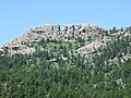 Horsetooth Rock, named for the profile of its east face. Hikers are visible on the summit.
 Upper Spring Creek valley on Horsetooth Mountain.


See also
- List of Colorado mountain ranges
- List of Colorado mountain summits
- List of Colorado county high points
References
- "HORSETOOTH". NGS data sheet. U.S. National Geodetic Survey. Retrieved November 4, 2014.
- The elevation of Horsetooth Mountain includes an adjustment of +1.018 m (+3.34 ft) from NGVD 29 to NAVD 88.
- "Horsetooth Mountain, Colorado". Peakbagger.com. Retrieved November 4, 2014.
- "Horsetooth Mountain". Geographic Names Information System. United States Geological Survey. Retrieved November 4, 2014.
- "Entrance Permits and Camping Prices". Larimer County. Retrieved 4 March 2020.
External links
 Definitions from Wiktionary
 Media from Commons
 News from Wikinews
 Quotations from Wikiquote
 Texts from Wikisource
 Textbooks from Wikibooks
 Resources from Wikiversity
- "Horsetooth Mountain Open Space". Larimer County.
Denver (capital) | ||
| Topics |
|  |
| Society |
| |
| Cities |
| |
| Counties |
| |
| Regions |
| |
| Federal |
| ||||||||||||||||||||||||||||||||
|---|---|---|---|---|---|---|---|---|---|---|---|---|---|---|---|---|---|---|---|---|---|---|---|---|---|---|---|---|---|---|---|---|---|
| State |
| ||||||||||||||||||||||||||||||||
| Trails |
| ||||||||||||||||||||||||||||||||
Colorado Department of Natural Resources (web) | |||||||||||||||||||||||||||||||||
Другой контент может иметь иную лицензию. Перед использованием материалов сайта WikiSort.org внимательно изучите правила лицензирования конкретных элементов наполнения сайта.
WikiSort.org - проект по пересортировке и дополнению контента Википедии