geo.wikisort.org - Mountains
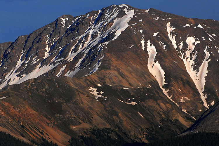
La Plata Peak is the fifth-highest summit of the Rocky Mountains of North America and the U.S. state of Colorado. The prominent 14,343-foot (4,372 m) fourteener is located in the Collegiate Peaks Wilderness of San Isabel National Forest, 22.7 miles (36.5 km) northwest by west (bearing 308°) of the Town of Buena Vista in Chaffee County, Colorado, United States.[3][1][2]
| La Plata Peak | |
|---|---|
 | |
| Highest point | |
| Elevation | 14,361 ft (4372 m)[1] NAVD88 |
| Prominence | 1836 ft (560 m)[1] |
| Isolation | 6.28 mi (10.11 km)[1] |
| Listing | |
| Coordinates | 39°01′46″N 106°28′22″W[2] |
| Geography | |
 La Plata Peak | |
| Location | Chaffee County, Colorado, U.S.[2] |
| Parent range | Sawatch Range, Collegiate Peaks[1] |
| Topo map | USGS 7.5' topographic map Mount Elbert, Colorado[2] |
| Climbing | |
| First ascent | July 26, 1873 Hayden Survey |
| Easiest route | Northwest Ridge or Southwest Ridge: Hike (class 2) |
"La Plata" is Spanish for "The Silver", a reference to the many silver deposits in the area. The nearby ghost towns of Winfield and Hamilton were prominent silver mining towns in the early part of the 20th century. A Hayden Survey team first climbed the peak on July 26, 1873.[4]
The elevation of 14,361 feet marked on the USGS Mount Elbert Quadrangle is incorrect, and should read 14,336 feet (in the NGVD 29 vertical datum).[5]
Climbing Routes
Northwest Ridge: This is the standard route used to climb the mountain. like most Sawatch range 14ers it is non-technical, but incredibly steep. The trail is 9.5 miles round trip, with 4,500 feet of elevation gain and class 2 hiking along the ridge.[6]
Ellingwood Ridge: Ellingwood Ridge is one of the most technically difficult alternate routes in the Sawatch range. it was first climbed by Albert Ellingwood in the 1930s.[7] It is rated as class 3, but the extremely difficult route finding and length of the climb make this a very challenging endeavor. Much of the climbing is off trail. The climb is 9.5 miles round trip, with 5,900 feet of elevation gain.[8]
See also
References
- "La Plata Peak, Colorado". Peakbagger.com. Retrieved January 2, 2016.
- "La Plata Peak". Geographic Names Information System. United States Geological Survey, United States Department of the Interior. Retrieved October 20, 2014.
- The elevation of La Plata Peak includes an adjustment of +1.983 m (+6.51 ft) from NGVD 29 to NAVD 88.
- "La Plata Peak". SummitPost.org. Retrieved 2008-11-30.
- Gerry Roach (1999). Colorado's Fourteeners: From Hikes to Climbs. Fulcrum Publishing. pp. 98–. ISBN 978-1-55591-412-7.
- Middlebrook, Bill. "La Plata Peak Northwest Ridge". 14ers.com. Retrieved 8 March 2022.
- Teissier, Warren. "Rock Climb Ellingwood Ridge". Mountainproject.com. Retrieved 8 March 2022.
- Snider, Brad. "La Plata Peak Ellingwood Ridge". 14ers.com. Retrieved 8 March 2022.
External links
 Definitions from Wiktionary
 Media from Commons
 News from Wikinews
 Quotations from Wikiquote
 Texts from Wikisource
 Textbooks from Wikibooks
 Resources from Wikiversity
- "La Plata Peak". Colorado Fourteeners Initiative. Archived from the original on 2008-05-09. Retrieved 2008-11-30.
- "La Plata Peak Trail". San Isabel National Forest. US Forest Service. Retrieved 2008-11-30.
- "La Plata Peak". 14ers.com. Retrieved 2014-08-17.
|
|
State of Colorado | |
|---|---|
Denver (capital) | |
| Topics |
|
| Society |
|
| Cities |
|
| Counties |
|
| Regions |
|
На других языках
[de] La Plata Peak
Der La Plata Peak ist mit 4.369 m einer der 54 „Fourteeners“ in den Rocky Mountains auf dem Gebiet des US-Bundesstaates Colorado. Er liegt in der Bergkette Sawatch Range im Chaffee County etwa 32 Kilometer südwestlich von Leadville. Der La Plata Peak liegt ganz im San Isabel National Forest und im Collegiate Peaks Wilderness.- [en] La Plata Peak
[fr] Pic La Plata
Le pic La Plata, en anglais La Plata Peak, est un sommet montagneux américain dans le comté de Chaffee, au Colorado. Il culmine à 4 377 mètres d'altitude dans les pics Collegiate. Il est protégé au sein de la forêt nationale de San Isabel et de la Collegiate Peaks Wilderness.Другой контент может иметь иную лицензию. Перед использованием материалов сайта WikiSort.org внимательно изучите правила лицензирования конкретных элементов наполнения сайта.
WikiSort.org - проект по пересортировке и дополнению контента Википедии