geo.wikisort.org - Mountains
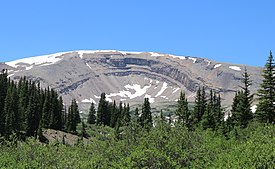
Horseshoe Mountain is a high mountain summit in the Mosquito Range of the Rocky Mountains of North America. The 13,905-foot (4,238 m) thirteener is located 7.1 miles (11.5 km) southeast by east (bearing 126°) of the City of Leadville, Colorado, United States, on the drainage divide separating San Isabel National Forest and Lake County from Pike National Forest and Park County.[1][2][3]
| Horseshoe Mountain | |
|---|---|
 The mountain and its prominent cirque | |
| Highest point | |
| Elevation | 13,905 ft (4,238 m)[1][2] |
| Prominence | 758 ft (231 m)[2] |
| Isolation | 2.83 mi (4.55 km)[2] |
| Coordinates | 39°11′09″N 106°11′07″W[3] |
| Geography | |
 Horseshoe Mountain Colorado | |
| Location | Lake and Park counties, Colorado, United States[3] |
| Parent range | Mosquito Range[2] |
| Topo map | USGS 7.5' topographic map Mount Sherman, Colorado[3] |
| Climbing | |
| Easiest route | hike |
Cirque
The mountain has a unique and prominent cirque. The cirque is tilted and made up of Paleozoic sedimentary rocks that formed on the floors of ancient seas. It is rare to find sedimentary rocks this high up in Colorado's higher elevations, for most sedimentary stata in the high country were eroded away by glaciers during the ice age. In this case, the glaciers sculpted the strata into a horseshoe shape without eroding it completely.[4][5]
See also
- List of Colorado mountain ranges
- List of Colorado mountain summits
- List of Colorado county high points
References
- The elevation of Horseshoe Mountain includes an adjustment of +2.031 m (+6.66 ft) from NGVD 29 to NAVD 88.
- "Horseshoe Mountain, Colorado". Peakbagger.com. Retrieved November 10, 2014.
- "Horseshoe Mountain". Geographic Names Information System. United States Geological Survey. Retrieved November 10, 2014.
- Hopkins, Ralph Lee; Hopkins, Lindy Birkel (2000). Hiking Colorado's geology. Seattle, WA: Mountaineers. p. 113-116. ISBN 0898866693. LCCN 99050995.
- Williams, Felicie; Chronic, Halka (2014). Roadside geology of Colorado (3rd ed.). Missoula, Montana: Mountain Press Publishing Company. p. 195. ISBN 9780878426096. LCCN 2013025258.
Другой контент может иметь иную лицензию. Перед использованием материалов сайта WikiSort.org внимательно изучите правила лицензирования конкретных элементов наполнения сайта.
WikiSort.org - проект по пересортировке и дополнению контента Википедии
