geo.wikisort.org - Mountains
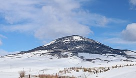
Tomichi Dome[5] rises north of U.S. Highway 50 west of Hot Springs Creek and south of Waunita Hot Springs Reservoir in the southeast quarter of Gunnison County, Colorado. It is situated within the Gunnison National Forest.
| Tomichi Dome | |
|---|---|
 Tomichi Dome viewed from U.S. Route 50 | |
| Highest point | |
| Elevation | 11,471 ft (3,496 m)[1][2] |
| Prominence | 2,325 ft (709 m)[2] |
| Isolation | 10.74 mi (17.28 km)[2] |
| Listing | Colorado prominent summits |
| Coordinates | 38°29′06″N 106°31′44″W[3] |
| Geography | |
 Tomichi Dome Colorado | |
| Location | Gunnison County, Colorado, U.S.[3] |
| Parent range | Sawatch Range[2] |
| Topo map | USGS 7.5' topographic map Doyleville, Colorado[3] |
Geology
Tomichi Dome is a prominent igneous mountain formed during the Tertiary. The predominant rock is rhyolite, but microgranite, breccia, and tuff have been cited as present. Surrounding the mountain, on the valley floor, is Mancos Shale, a Mesozoic sedimentary rock.[6][7][8]
Tomchi Dome has been described as an intrusion and also as an extrusive, volcanic feature. As an intrusion, the pluton may have formed when magma was intruded into the Mancos Shale resulting in a laccolith. Given the fine-grained texture of the rock, the laccolith is assumed to have been at a shallow depth and cooled rapidly. Venting may have been associated with the intrusion resulting in the rhyolytic breccia and tuff documented in the vicinity. Shallow rhyolitic plutons southwest of Tomichi Dome, in the San Juan Mountains near Lake City, have also been described as laccoliths.[8][9][10]
Alternatively, Tomichi Dome has been described as an extrusive, volcanic feature where the initial eruptions deposited breccia and tuff that is over 670 feet (200 m) thick. A flow or dome of topaz rhyolite overlies the tuff.[8][11][12]
Whether plutonic or volcanic, Tomichi Dome is possibly one of a string of igneous structures associated with the Rio Grande Rift, which stretches from Mexico to Colorado.[8][11]
Historical names
- Tomichi Dome – 1907 [3]
- Tumitche Dome
See also
- List of Colorado mountain ranges
- List of Colorado mountain summits
- List of Colorado county high points
Notes
- The elevation of Tomichi Dome includes an adjustment of +1.693 m (+5.55 ft) from NGVD 29 to NAVD 88.
- "Tomichi Dome, Colorado". Peakbagger.com. Retrieved October 22, 2014.
- "Tomichi Dome". Geographic Names Information System. United States Geological Survey, United States Department of the Interior. Retrieved October 22, 2014.
- Benson, Maxine (1994). 1001 Colorado Place Names. Lawrence: University Press of Kansas. ISBN 0-7006-0632-7.
- Pronounced /toʊˈmiːtʃiː/ (
 listen).[4]
 - "The National Geologic Map Database". United States Geological Survey. Retrieved 29 November 2017.
- Streufert, R.K.; Morgan, M.L.; Eakins, Wynn; Hemborg, H.T. (1999). Geology and Mineral Resources of Gunnison County, Colorado. Resource Series RS-37. Denver, Colorado: Colorado Geological Survey. Retrieved 2021-08-19.
- Christiansen, Eric H.; Sheridan, Michael F.; Burt, Donald M. (1986). The geology and geochemistry of Cenozoic topaz rhyolites from the Western United States (PDF). Special Paper. Vol. 205. Geological Society of America.
- Corry, Charles E. (1988). Laccoliths: mechanics of emplacement and growth. Special Paper. Vol. 220 (2nd ed.). Geological Society of America.
- Prather, Thomas (1999). Geology of the Gunnison Country (2nd ed.). Gunnison, Colorado: B&B Printers. LCCN 82-177244.
- Burt, Donald M.; Sheridan, Michael F.; Bikun, James V.; Christiansen, Erics H. (1982). "Topaz rhyolites--distribution, origin, and significance for exploration". Economic Geology. 77 (8): 1818–1836. doi:10.2113/gsecongeo.77.8.1818. ISSN 0361-0128.
- Stark, J. T.; Behre, Jr., C. H. (1936). "Tomichi Dome Flow". GSA Bulletin. 47 (1): 101–110. doi:10.1130/GSAB-47-101.
- Maps:
- Gunnison Basin Public Lands. Forest Service Series Map. United States Department of Agriculture. Colorado, 2008.
External links
Другой контент может иметь иную лицензию. Перед использованием материалов сайта WikiSort.org внимательно изучите правила лицензирования конкретных элементов наполнения сайта.
WikiSort.org - проект по пересортировке и дополнению контента Википедии