geo.wikisort.org - Mountains
Dallas Peak is a high mountain summit in the Sneffels Range of the Rocky Mountains of North America. The 13,815-foot (4,211 m) thirteener is located in the Mount Sneffels Wilderness of Uncompahgre National Forest, 3.3 miles (5.3 km) north by west (bearing 354°) of the Town of Telluride, Colorado, United States, on the drainage divide between Ouray and San Miguel counties.[1][2][3]
| Dallas Peak | |
|---|---|
 South aspect | |
| Highest point | |
| Elevation | 13,815 ft (4,211 m)[1][2] |
| Prominence | 869 ft (265 m)[2] |
| Parent peak | Mount Sneffels |
| Isolation | 2.02 mi (3.25 km)[2] |
| Coordinates | 37°59′17″N 107°49′25″W[3] |
| Naming | |
| Etymology | George M. Dallas |
| Geography | |
 Dallas Peak Colorado | |
| Location | Ouray and San Miguel counties, Colorado, United States[3] |
| Parent range | San Juan Mountains, Sneffels Range[2] |
| Topo map | USGS 7.5' topographic map Telluride, Colorado[3] |
Etymology
This mountain's name was officially adopted by the U.S. Board on Geographic Names to commemorate George M. Dallas (1792–1864), American politician and diplomat who served as mayor of Philadelphia from 1828 to 1829, and as the 11th vice president of the United States from 1845 to 1849.[4]
Climate
According to the Köppen climate classification system, Dallas Peak is located in an alpine subarctic climate zone with long, cold, snowy winters, and cool to warm summers.[5] Due to its altitude, it receives precipitation all year, as snow in winter, and as thunderstorms in summer, with a dry period in late spring. Precipitation runoff from the mountain drains south into the San Miguel River, and north to the Uncompahgre River via Dallas Creek.
Gallery
 Dallas Peak seen with Blue Lakes
 Dallas Peak seen from Mt. Sneffels
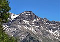
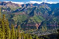 Dallas Peak in upper left corner, Telluride below.


See also
- List of Colorado mountain ranges
- List of Colorado mountain summits
- List of Colorado county high points
References
- The elevation of Dallas Peak includes an adjustment of +1.861 m (+6.11 ft) from NGVD 29 to NAVD 88.
- "Dallas Peak, Colorado". Peakbagger.com. Retrieved November 5, 2014.
- "Dallas Peak". Geographic Names Information System. United States Geological Survey. Retrieved November 5, 2014.
- Stewart M. Green, Scenic Driving Colorado: Exploring the State's Most Spectacular Back Roads, 2019, Globe Pequot, ISBN 9781493035991, page 254.
- Peel, M. C.; Finlayson, B. L.; McMahon, T. A. (2007). "Updated world map of the Köppen−Geiger climate classification". Hydrology and Earth System Sciences. 11. ISSN 1027-5606.
External links
- Weather forecast: Dallas Peak
 Definitions from Wiktionary
 Media from Commons
 News from Wikinews
 Quotations from Wikiquote
 Texts from Wikisource
 Textbooks from Wikibooks
 Resources from Wikiversity
Denver (capital) | ||
| Topics |
|  |
| Society |
| |
| Cities |
| |
| Counties |
| |
| Regions |
| |
| Federal |
| ||||||||||||||||||||||||||||||||
|---|---|---|---|---|---|---|---|---|---|---|---|---|---|---|---|---|---|---|---|---|---|---|---|---|---|---|---|---|---|---|---|---|---|
| State |
| ||||||||||||||||||||||||||||||||
| Trails |
| ||||||||||||||||||||||||||||||||
Colorado Department of Natural Resources (web) | |||||||||||||||||||||||||||||||||
This Colorado state location article is a stub. You can help Wikipedia by expanding it. |
Другой контент может иметь иную лицензию. Перед использованием материалов сайта WikiSort.org внимательно изучите правила лицензирования конкретных элементов наполнения сайта.
WikiSort.org - проект по пересортировке и дополнению контента Википедии