geo.wikisort.org - Mountains
Snowdon Peak is a 13,077-foot-elevation (3,986 meter) mountain summit located in San Juan County, Colorado, United States.[3] It is situated seven miles south of the community of Silverton, in the Weminuche Wilderness, on land managed by San Juan National Forest. It is part of the San Juan Mountains range which is a subset of the Rocky Mountains of North America, and is set nine miles west of the Continental Divide. Topographic relief is significant as the east aspect rises 4,300 feet (1,310 meters) above the Animas River in approximately 1.5 mile. Neighbors include Mount Garfield three miles to the east-southeast, and Twilight Peak, which is the nearest higher peak, 3.7 miles to the south-southwest. This mountain can be seen from U.S. Route 550. The mountain is named after Snowdon, the highest mountain in Wales.[5]
| Snowdon Peak | |
|---|---|
 Northwest aspect | |
| Highest point | |
| Elevation | 13,077 ft (3,986 m)[1] |
| Prominence | 1,317 ft (401 m)[1] |
| Parent peak | Twilight Peak (13,163 ft)[2] |
| Isolation | 3.75 mi (6.04 km)[2] |
| Coordinates | 37°42′28″N 107°41′20″W[3] |
| Naming | |
| Etymology | Snowdon |
| Geography | |
 Snowdon Peak Location in Colorado  Snowdon Peak Snowdon Peak (the United States) | |
| Location | San Juan County, Colorado, US |
| Parent range | Rocky Mountains San Juan Mountains Needle Mountains[1] |
| Topo map | USGS Snowdon Peak |
| Geology | |
| Age of rock | Statherian |
| Type of rock | Quartzite |
| Climbing | |
| Easiest route | class 2+ scramble[2] NE ridge[4] |
Climate
According to the Köppen climate classification system, Snowdon Peak is located in an alpine subarctic climate zone with long, cold, snowy winters, and cool to warm summers.[6] Due to its altitude, it receives precipitation all year, as snow in winter, and as thunderstorms in summer, with a dry period in late spring. Precipitation runoff from the mountain drains into tributaries of the Animas River.
Geology
Snowdon Peak is part of the Uncompahgre Formation, which is a sequence of quartzite and black phyllite some 8,200 feet (2,500 meters) in thickness.[7] The formation dates to the Statherian period and is interpreted as metamorphosed marine and fluvial sandstone, mudstone, and shale. The formation overlies plutons with an age of 1,707 million years.
Gallery
 12,628' (left) and Snowdon Peak (right)
 Snowdon Peak from US Route 550
 Snowdon Peak from Highway 550
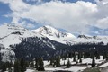 Snowdon Peak from Molas Pass
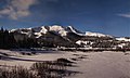 Snowdon Peak illuminated by moonlight
 Snowden Peak to left. West aspect, from near Coal Bank Pass
 Snowdon Peak to the right


See also
- Mountains of San Juan County, Colorado
References
- "Snowdon Peak, Colorado". Peakbagger.com.
- "Snowdon Peak - 13,077' CO". listsofjohn.com. Retrieved 2021-06-27.
- "Snowdon Peak". Geographic Names Information System. United States Geological Survey. Retrieved 2021-06-27.
- Robert F. Rosebrough, The San Juan Mountains: A Climbing & Hiking Guide, Cordillera Press, 1986, page 114.
- John Peel, Paul Pixler, Hiking Trails of Southwestern Colorado, 5th Ed., 2020, West Margin Press, ISBN 9781513262987, page 157.
- Peel, M. C.; Finlayson, B. L.; McMahon, T. A. (2007). "Updated world map of the Köppen−Geiger climate classification". Hydrol. Earth Syst. Sci. 11. ISSN 1027-5606.
- Rob Blair, Tom Ann Casey, William H. Romme, The Western San Juan Mountains: Their Geology, Ecology, and Human History, 1996, University Press of Colorado, ISBN 9780870813788, page 350.
External links
- Weather forecast: Snowdon Peak
Другой контент может иметь иную лицензию. Перед использованием материалов сайта WikiSort.org внимательно изучите правила лицензирования конкретных элементов наполнения сайта.
WikiSort.org - проект по пересортировке и дополнению контента Википедии