geo.wikisort.org - Mountains
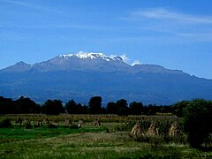
Iztaccíhuatl (alternative spellings include Ixtaccíhuatl, or either variant spelled without the accent) (Nahuatl pronunciation: [istakˈsiwat͡ɬ] (![]() listen) or, as spelled with the x, Nahuatl pronunciation: [iʃtakˈsiwat͡ɬ]), is a 5,230 m (17,160 ft)[1] dormant volcanic mountain in Mexico located on the border between the State of Mexico and Puebla within Izta-Popo Zoquiapan National Park. It is the nation's third highest, after Pico de Orizaba at 5,636 m (18,491 ft), and Popocatépetl at 5,426 m (17,802 ft).
listen) or, as spelled with the x, Nahuatl pronunciation: [iʃtakˈsiwat͡ɬ]), is a 5,230 m (17,160 ft)[1] dormant volcanic mountain in Mexico located on the border between the State of Mexico and Puebla within Izta-Popo Zoquiapan National Park. It is the nation's third highest, after Pico de Orizaba at 5,636 m (18,491 ft), and Popocatépetl at 5,426 m (17,802 ft).
| Iztaccíhuatl | |
|---|---|
 Iztaccíhuatl from Amecameca | |
| Highest point | |
| Elevation | 5,230 m (17,160 ft)[1] |
| Prominence | 1,530 m (5,020 ft)[2] |
| Listing | |
| Coordinates | 19°10′44″N 98°38′30″W[1] |
| Geography | |
 Iztaccíhuatl Location in Mexico  Iztaccíhuatl Iztaccíhuatl (North America) | |
| Location | México and Puebla, Mexico |
| Geology | |
| Volcanic arc/belt | Trans-Mexican Volcanic Belt |
| Last eruption | Holocene[1] |
| Climbing | |
| First ascent | 1889 by James de Salis |
| Easiest route | rock/snow climb |
The name "Iztaccíhuatl" is Nahuatl for "White woman", reflecting the four individual snow-capped peaks which depict the head, chest, knees and feet of a sleeping female when seen from east or west. Iztaccíhuatl is to the north of its twin Popocatépetl, to which it is connected by the high altitude Paso de Cortés. Depending on atmospheric conditions Iztaccíhuatl is visible much of the year from Mexico City some 70 km (43 mi) to the northwest. The first recorded ascent was made in 1889, though archaeological evidence suggests the Aztecs and previous cultures climbed it previously. It is the lowest peak containing permanent snow and glaciers in Mexico.
Geology
The summit ridge of the massive 450 km3 (110 cu mi) volcano is a series of overlapping cones constructed along a NNW-SSE line to the south of the Pleistocene Llano Grande caldera. There have been andesitic and dacitic Pleistocene and Holocene eruptions from vents at or near the summit. Areas near the El Pecho summit vent are covered in flows and tuff beds post-dating glaciation, approximately 11,000 years ago. The most recent vents are at El Pecho and a depression at 5,100 m (16,700 ft) along the summit ridge midway between El Pecho and Los Pies.[1]
Legend of Popocatépetl and Iztaccíhuatl

In Aztec mythology, Iztaccíhuatl was a princess who fell in love with one of her father's warriors, Popocatépetl. The emperor sent Popocatépetl to war in Oaxaca, promising him Iztaccíhuatl as his wife when he returned (which Iztaccíhuatl's father presumed he would not). Iztaccíhuatl was falsely told that Popocatépetl had died in battle, and believing the news, she died of grief. When Popocatépetl returned to find his love dead, he took her body to a spot outside Tenochtitlan and kneeled by her grave. The gods covered them with snow and changed them into mountains. Iztaccíhuatl's mountain is called "White Woman" (from Nahuatl iztāc "white" and cihuātl "woman") because it resembles a woman lying on her back, and is often covered with snow — the peak is sometimes nicknamed La Mujer Dormida, "The Sleeping Woman". Popocatépetl became an active volcano, raining fire on Earth in blind rage at the loss of his beloved.[3]
Elevation
Iztaccihuatl is usually listed at 5,286 m (17,343 ft), but SRTM data and the Mexican national mapping survey assert that a range of 5,220 to 5,230 m (17,130 to 17,160 ft) is more accurate.[4][5] The Global Volcanism Program cites 5,230 m (17,160 ft).[1]
Gallery
 Iztaccíhuatl from the Puebla side
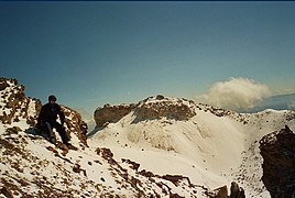 Around the Knees (5,000 m (3.1 mi)) of Iztaccíhuatl
 Forest fires on the slopes
 View from the ridge of Mt. Izta towards Pico de Orizaba
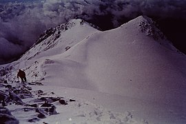 Iztaccihuatl Ridge after the mountain shelter


See also
References
- "Iztaccíhuatl". Global Volcanism Program. Smithsonian Institution. Retrieved 2010-06-22.
- "Volcán Iztaccíhuatl". Summits of the World. peakbagger.com. Retrieved 30 June 2010.
- "The Legend of Popocatépetl and Iztaccíhuatl". Online guide to Mexico.
- "Elevaciones principales - Puebla" (in Spanish). Instituto Nacional de Estadística, Geografía e Informática. Archived from the original on 10 March 2012. Retrieved 17 March 2009.
- "Lo más y lo menos del territorio de México - Montañas (más altas)" (in Spanish). Instituto Nacional de Estadística, Geografía e Informática. Archived from the original on 3 March 2012. Retrieved 22 February 2009.
External links
 Definitions from Wiktionary
 Media from Commons
 News from Wikinews
 Quotations from Wikiquote
 Texts from Wikisource
 Textbooks from Wikibooks
 Resources from Wikiversity
Descriptions
- Iztaccíhuatl - Volcano World
- Iztaccíhuatl - Ski Mountaineer
- "Iztaccihuatl". Peakware.com. Archived from the original on 2016-03-04.
Other
Authority control | |
|---|---|
| General |
|
| Other |
|
На других языках
[de] Iztaccíhuatl
Der Iztaccíhuatl [.mw-parser-output .IPA a{text-decoration:none}istakˈsiwatɬ] (auch Ixtaccíhuatl [iʃtakˈsiwatɬ], in neuer Nahuatl-Schreibweise Istaksiwatl, auch Iztactépetl bzw. Istaktepetl oder auch Mujer dormida ‚schlafende Frau‘) ist mit 5230 m der dritthöchste Berg Mexikos nach dem Citlaltépetl und dem Popocatépetl.- [en] Iztaccihuatl
[es] Iztaccíhuatl
El Iztaccíhuatl (pronunciado [istaːkˈsiwaːt͡ɬ] ( escuchar)) (en náhuatl: Istaksiwatl ‘Mujer Blanca’‘istak, blanco; siwatl, mujer’)[3] es un volcán sísmicamente activo ubicado en el centro de México y es la tercera montaña más alta del país (5215.128 m s. n. m.)[4], después del Pico de Orizaba (5747 m s. n. m.)[5][6] y el Popocatépetl (5426 m s. n. m.).[5] Se localiza en los límites territoriales de los estados de México y Puebla. Su nombre proviene de su perfil nevado, que desde el valle de México semeja a una mujer yaciente cubierta de un manto blanco.[fr] Iztaccíhuatl
L'Iztaccíhuatl[1] (aussi écrit Ixtaccíhuatl) est la troisième montagne la plus haute du Mexique après le pic d'Orizaba (5 636 m) et le Popocatépetl (5 452 m). Son nom vient du nahuatl « femme blanche » (iztac voulant dire blanc/blanche et cíhuatl, femme)[2]. Il est l'un des éléments centraux du parc national Iztaccíhuatl-Popocatépetl.[it] Iztaccíhuatl
L'Iztaccíhuatl o Ixtaccíhuatl (grafia spagnola) oppure Iztaccihuātl o Ixtaccihuātl (grafia nahuatl classica) (pronunciati rispettivamente [istakˈsiwat͡ɬ] e [iʃtakˈsiwat͡ɬ]; dal nahuatl iztac ‘bianco come il sale’, e cihuātl ‘donna’, quindi ‘donna bianca’; comunemente chiamato Iztla), è la terza montagna più alta del Messico, dopo il Pico de Orizaba (5 610 m s.l.m.) ed il Popocatépetl (5 452 m s.l.m.) e anche la quinta più alta del Nord America.[ru] Истаксиуатль
Истакси́уатль, или Истасиуатль (исп. Iztaccíhuatl) (происходит из языка науатль: истак — белый и сиуатль — женщина, то есть Белая женщина) — третья по высоте вершина Мексики (после вулканов Орисаба, 5 636 м, и Попокатепетль, 5 426 м). В обиходе гору называют просто Иста.Другой контент может иметь иную лицензию. Перед использованием материалов сайта WikiSort.org внимательно изучите правила лицензирования конкретных элементов наполнения сайта.
WikiSort.org - проект по пересортировке и дополнению контента Википедии