geo.wikisort.org - Mountains
Mount Blackburn is the highest peak in the Wrangell Mountains of Alaska in the United States. It is the fifth-highest peak[2] in the United States and the twelfth-highest peak in North America. The mountain is an old, eroded shield volcano, the second-highest volcano in the U.S. behind Mount Bona and the fifth-highest in North America. It was named in 1885 by Lt. Henry T. Allen of the U.S. Army after Joseph Clay Stiles Blackburn, a U.S. senator from Kentucky.[3] It is located in the heart of Wrangell – St. Elias National Park, the largest national park in the country.
| Mount Blackburn | |
|---|---|
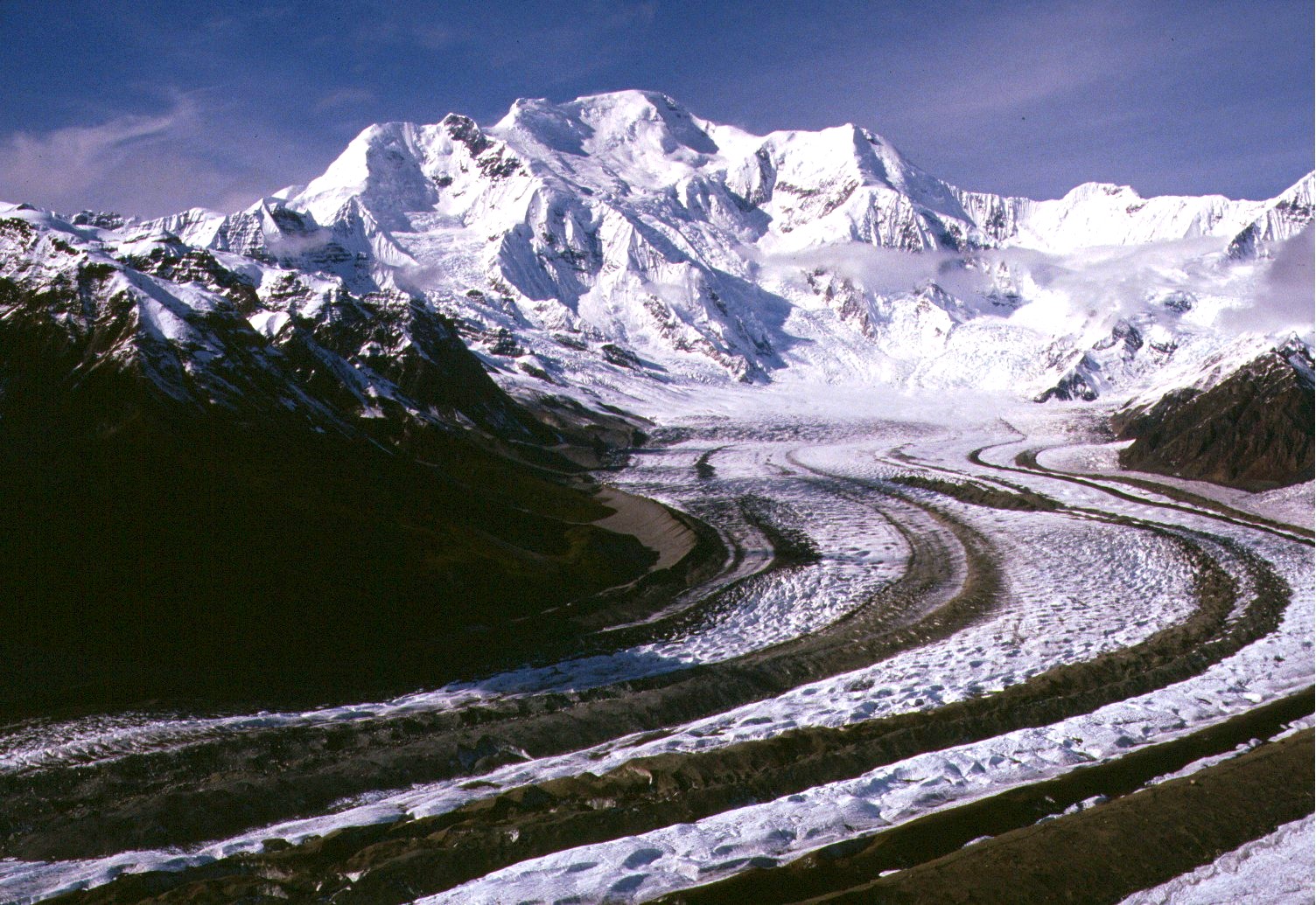 Mount Blackburn from the southeast, looking up the Kennicott Glacier | |
| Highest point | |
| Elevation | 16,390 ft (4996 m)[1] NAVD88 |
| Prominence | 11,640 ft (3548 m)[1] |
| Isolation | 60.7 mi (97.6 km)[1] |
| Listing |
|
| Coordinates | 61°43′54″N 143°25′59″W |
| Naming | |
| Etymology | Joseph Clay Stiles Blackburn |
| Geography | |
 Mount Blackburn Location in Alaska | |
| Location | Wrangell-St. Elias National Park and Preserve, Alaska, U.S. |
| Parent range | Wrangell Mountains |
| Topo map | USGS McCarthy C-7 |
| Geology | |
| Age of rock | 3.4 to 5 million years |
| Mountain type | Shield volcano |
| Last eruption | 3.4 million years ago |
| Climbing | |
| First ascent | 1958 (true summit) Gilbert, Wahlstrom, Gmoser, Bitterlich, and Blumer |
| Easiest route | North Ridge: snow/glacier climb |
Description
The mountain's massif is covered almost entirely by icefields and glaciers and is the principal source of ice for the Kennicott Glacier, which flows southeast over 20 miles (32 km) to just above the town of McCarthy. The mountain also contributes a large volume of ice to the north-flowing Nabesna Glacier and the Kuskulana Glacier system.
Mount Blackburn is a large, dramatic peak, with great local relief and independence from higher peaks. Its west face drops over 11,000 ft (3,350 m) to the Kuskulana Glacier in less than 4 horizontal miles (6.4 km). Its other faces drop 8,000–10,000 ft (2,440–3,050 m), all in less than 8 miles (13 km). The toe of the Kuskulana Glacier, less than 12 miles (19 km) from the summit, lies at an elevation of 2,400 ft (730 m), giving a rise of 14,000 ft (4,270 m). While these figures speak to the peak's relief, one measure of its independence is that it is the 50th-most topographically prominent peak in the world.[4]
The western of Blackburn's two summits is the mountain's highest point, a fact that was not understood until the 1960s when new USGS maps were published. The first ascent of the west peak, and hence Mount Blackburn, was done on May 30, 1958, by Bruce Gilbert, Dick Wahlstrom, Hans Gmoser, Adolf Bitterlich, and Leon Blumer via the North (also called the Northwest) Ridge. This team made the first ascent of Blackburn but did not even know it at the time due to the incorrect identification of the highest point. Blumer's article in the 1959 American Alpine Journal is titled "Mount Blackburn – Second Ascent."

Other subfeatures

Kennedy Peak, or East Blackburn, 16,286 ft (4,964 m), is the eastern summit and was originally thought to be the highest point. The first ascent of this summit was made in 1912 by Dora Keen and George Handy via the Kennicott Glacier (on the south side of the mountain) and East Face. This heady exploit was ahead of its time. Dora Keen, driven by a deep desire for the climb, solicited miners from the nearby Kennecott Copper Mines, and forged a route up the heavily crevassed East Face to the East Peak, but did not traverse over to the West Peak. Keen went on to write a famous article for the Saturday Evening Post titled, "First up Mount Blackburn." In 1912, Keen and Handy thought they were on Blackburn's highest point.
Geology
Mount Blackburn represents the heavily eroded core of a shield volcano. Because it is shrouded in permanent ice, its internal structure cannot be determined. It is believed to have a summit caldera, greatly modified by glaciation. The oldest rocks in the area are granites, about 4.2 million years old, representing an intrusive mass. The majority of the mountain is 3.4 million year old granite, intruding between andesite flows. From this it is inferred that a caldera collapse took place between 4.2 and 3.4 million years ago, after which activity ceased.[5]
Climbing
Today's standard route on the peak is the 1958 ascent route, the North (or Northwest) Ridge, which is approached from the Nabesna Glacier, on the north side of the mountain, opposite from Keen and Hardy's route. The route starts from an airstrip on the glacier at an altitude of 7,200 feet (2,200 m). It is a moderate climb by Alaskan standards (Alaska Grade 2).
See also
- List of mountain peaks of North America
- List of the highest major summits of the United States
- List of the most prominent summits of the United States
- List of the most isolated major summits of the United States
- List of volcanoes in the United States
References and notes
- "Mount Blackburn, Alaska". Peakbagger.com. Retrieved December 30, 2015.
- This is not counting the North Summit of Denali, which is sometimes counted as an independent peak and sometimes not.
- "USGS GNIS: Mount Blackburn". Retrieved March 8, 2007.
- "Peaklist.org: 50 Most Prominent Peaks on Earth". peaklist.org. Retrieved March 9, 2007.
- Richter, Donald H.; Rosenkrans, Danny S.; Steigerwald, Margaret J. "Guide to the Volcanoes of the Western Wrangll Mountains, Alaska, U.S. Geological Survey Bulletin 2072" (PDF). U.S. Geological Survey.
Sources
- Wood, Michael; Coombs, Colby (2001). Alaska: A Climbing Guide. Mountaineers Books. ISBN 0-89886-724-X.
- Richter, Donald H.; Rosenkrans, Danny S.; Steigerwald, Margaret J. (1995). Guide to the Volcanoes of the Western Wrangell Mountains, Alaska (PDF). USGS Bulletin 2072.
- Winkler, Gary R. (2000). A Geologic Guide to Wrangell—Saint Elias National Park and Preserve, Alaska: A Tectonic Collage of Northbound Terranes. USGS Professional Paper 1616. ISBN 0-607-92676-7.
- Richter, Donald H.; Preller, Cindi C.; Labay, Keith A.; Shew, Nora B. (2006). Geologic Map of the Wrangell-Saint Elias National Park and Preserve, Alaska. USGS Scientific Investigations Map 2877.
External links
 Definitions from Wiktionary
 Media from Commons
 News from Wikinews
 Quotations from Wikiquote
 Texts from Wikisource
 Textbooks from Wikibooks
 Resources from Wikiversity
Juneau (capital) | |
| Topics |
|
| Society |
|
| Regions |
|
| Largest cities pop. over 25,000 | |
| Smaller cities pop. over 2,000 | |
| Boroughs |
|
| Native Corporations |
|
| Census Areas |
|
Authority control | |
|---|---|
| General |
|
| National libraries | |
На других языках
[de] Mount Blackburn
Mount Blackburn ist mit 4996 m der höchste Gipfel der Wrangell Mountains in Alaska. Er ist außerdem der fünfthöchste Berg der Vereinigten Staaten und der zwölfthöchste Nordamerikas. Der stark erodierte Schildvulkan ist nach Mount Bona der höchste Vulkan in den USA und der fünfthöchste in Nordamerika. 1885 benannte ihn Henry T. Allen nach dem US-Senator Joseph Clay Stiles Blackburn aus Kentucky.- [en] Mount Blackburn
[fr] Mont Blackburn
Le mont Blackburn est un sommet de l'Alaska, aux États-Unis. Il s'élève à 4 996 mètres d'altitude et constitue le point culminant des montagnes Wrangell. Il s'agit d'un vieux stratovolcan éteint, érodé et couvert de glaces. Il a été escaladé pour la première fois le 30 mai 1958. Son ascension, par le versant nord, ne présente plus de difficulté particulière. Il se trouve dans le parc national de Wrangell-St. Elias.[it] Monte Blackburn
Il monte Blackburn è una montagna degli Stati Uniti d'America, situata nello Stato dell'Alaska. Si trova all'interno del Wrangell-St. Elias National Park and Preserve, e con i suoi 4.996 m s.l.m. rappresenta la vetta principale della catena montuosa dei Monti Wrangell.[ru] Блэкберн (вулкан)
Блэкберн (англ. Mount Blackburn) — потухший щитовидный вулкан в горах Врангеля, штат Аляска, США. Высота 4996 метров, это пятый по высоте пик в Соединённых штатах и двенадцатый в Северной Америке, второй по высоте вулкан в США и пятый в Северной Америке. Своё название получил в ходе экспедиции 1885 года в честь Джозефа Блэкберна, сенатора США от штата Кентукки[1].Другой контент может иметь иную лицензию. Перед использованием материалов сайта WikiSort.org внимательно изучите правила лицензирования конкретных элементов наполнения сайта.
WikiSort.org - проект по пересортировке и дополнению контента Википедии