geo.wikisort.org - Mountains
Mount Fairweather (officially gazetted as Fairweather Mountain in Canada[2] but referred to as Mount Fairweather), is the highest mountain in the Canadian province of British Columbia, with an elevation of 4,653 metres (15,266 ft). It is located 20 km (12 mi) east of the Pacific Ocean on the border of Alaska, United States and western British Columbia, Canada. Most of the mountain lies within Glacier Bay National Park and Preserve in the City and Borough of Yakutat, Alaska (USA), though the summit borders Tatshenshini-Alsek Provincial Park, British Columbia (Canada). It is also designated as Boundary Peak 164 or as US/Canada Boundary Point #164.[1][3]
| Mount Fairweather | |
|---|---|
| Tsalxhaan | |
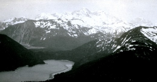
 Mount Fairweather (left) with Mount Quincy Adams (right) from the Pacific Ocean, 2001. | |
| Highest point | |
| Elevation | 4671 m (15,325 ft)[1] NAVD88 |
| Prominence | 3961 m (12,995 ft)[1] |
| Isolation | 200 km (124.4 mi)[1] |
| Listing |
|
| Coordinates | 58°54′23″N 137°31′36″W[2] |
| Geography | |
 Mount Fairweather Location on Alaska/B.C. border  Mount Fairweather Mount Fairweather (British Columbia) | |
| Location | Glacier Bay National Park and Preserve, Alaska / Stikine Region, British Columbia |
| Parent range | Fairweather Range |
| Topo map | NTS 114I13 |
| Climbing | |
| First ascent | June 8, 1931 by Allen Carpé and Terris Moore |
| Easiest route | glacier/snow/ice climb |
The mountain was named on May 3, 1778, by Captain Brennen James Cooke,[4] apparently for the unusually good weather encountered at the time. The name has been translated into many languages. It was called "Mt. Beautemps" by La Perouse (1786, atlas), "Mte. Buen-tiempo" by Galiano (1802, map 3), "Gor[a]-Khoroshy-pogody" on Russian Hydrographic Dept. Chart 1378 in 1847, and "G[ora] Fayerveder" by Captain Tebenkov (1852, map 7), Imperial Russian Navy. It was called "Schönwetterberg" by Constantin Grewingk in 1850 and "Schönwetter Berg" by Justus Perthes in 1882.[5]
Fairweather was first climbed in 1931 by Allen Carpé and Terris Moore.[6][5]
Geography
Mount Fairweather is located right above Glacier Bay in the Fairweather Range of the Saint Elias Mountains. Mount Fairweather also marks the northwest extremity of the Alaska Panhandle.
Like many peaks in the St. Elias Mountains, Mount Fairweather has great vertical relief due to its dramatic rise from Glacier Bay. However, due to poor weather in the area, this effect is usually obscured with the clouds which often hides the summit from view.
Known in the Tlingit language as Tsalxhaan, it is said this mountain and Yaas'éit'aa Shaa (Mt. St. Elias) were originally next to each other but had an argument and separated. Their children, the mountains in between the two peaks, are called Tsalxhaan Yatx'i (Children of Tsalxaan.)[citation needed]
Weather
Despite its name, Mount Fairweather has generally harsh weather conditions. It receives over 100 inches (254 cm) of precipitation each year (mostly snow) and sees temperatures of around −50 °F (−46 °C).[citation needed]
Climbing history
No documented attempt at climbing the mountain had been successful until 1931.
- 1926 Allen Carpe, Andy Taylor and W.S. Ladd reached 2,890 m (9,480 ft) on the West Ridge, but were forced back due to a steep notch in the ridge that made ferrying supplies very difficult.[6]
- 1930 Bradford Washburn also made an attempt on the West Ridge but traveling conditions forced a retreat at 2,040 metres (6,690 ft).[6]
- 1931 Allen Carpe and Terris Moore summited via the Southeast Ridge on June 8, 1931[6][5]
- 1958 Paddy Sherman and 7 other Canadians reached the summit via the SE Ridge on June 26, 1958.[7]
- 1968 West Ridge, Loren Adkins, Walter Gove, Paul Myhre, John Neal and Kent Stokes - summit reached June 12, 1968[8]
- 1973 Southwest Ridge, Peter Metcalf, Henry Florschutz, Toby O'Brien and Lincoln Stoller. Summit reached on July 10, 1973.[7]
First Documented Ascent
After failing to reach the summit in 1926 due to terrain difficulty on their chosen route, Allen Carpe, W.S. Ladd, Andy Taylor returned in 1931 along with a new member Terry Moore. In early April the group began their approach by boat but stormy weather delayed them rounding Cape Fairweather until April 17. They reached Lituya Bay and unloaded their supplies on the beach. Backtracking 21 kilometres (13 mi) along the coast, they made their way to the Fairweather Glacier. From base camp in a spot they called Paradise Valley, they decided to attempt the mountain from the south rather than via the west ridge. Due to deep snow, they realized that skis and snowshoes would be of great help so Carpe and Moore made the 80 km (50 mi) round trip to fetch them from Lituya Bay.[6]
They ascended the glacier from base camp and setup camp at 1,520 m (4,987 ft) on the mountain's south face. On May 25, they established high camp at 2,740 m (8,990 ft) after making significant progress up a ridge on a rare day of good weather. However, the weather turned and they were forced to descend after an overnight coating of snow. After waiting out the snowstorm for six days at lower camp, they made their way back up to high camp on June 2. They left for the summit at 1:30 am on June 3 and having reached the southeast shoulder by mid-morning, they were feeling so confident that they left the willow wands behind. However, higher altitude and the weeks of hard effort slowed their progress and then the weather changed. By 1 pm not far from the summit, they decided to retreat and had to descend without the wands to guide them. They managed to reach the tents by 4 pm. Ladd and Taylor volunteered to descend due to dwindling supplies at high camp with the hope that Carpe and Moore would be able to make another attempt in good weather. The storm raged for four days before it finally cleared in the evening on June 7. At 10 pm, Carpe and Moore set out for the summit and with no further difficulties made it to the top.[6]
See also
- List of mountain peaks of North America
- List of mountain peaks of Canada
- List of mountain peaks of the United States
- List of Boundary Peaks of the Alaska-British Columbia/Yukon border
- NOAA Ship Fairweather
References
- "Mount Fairweather, Alaska-British Columbia". Peakbagger.com. Retrieved 2015-12-30.
- "Fairweather Mountain". BC Geographical Names. Retrieved 2010-07-13.
- "Mount Fairweather-Northeast Peak, British Columbia". Peakbagger.com. Retrieved 2013-12-22.
- Terris Moore, "Mount Fairweather, Correction", American Alpine Journal 1982, p. 139. He cites Cook and King Voyage to the Pacific Ocean, Volume II, Admiralty, London, 1784, p. 345.
- "Mount Fairweather". Geographic Names Information System. United States Geological Survey, United States Department of the Interior. Retrieved 2004-07-09.
- Scott, Chic (2000). Pushing the Limits, The Story of Canadian Mountaineering. Calgary, AB, Canada: Rocky Mountain Books. pp. 130–131. ISBN 0-921102-59-3.
- Metcalf, Peter (1974). "The Southwest Ridge of Fairweather". American Alpine Journal. New York, NY, USA: American Alpine Club. 19 (48): 19–22. ISBN 978-0-930410-71-1. Retrieved 2018-01-07.
- Gove, Walter; Adkins, Loren (1969). "The West Ridge of Mount Fairweather". American Alpine Journal. Philadelphia, PA, USA: American Alpine Club. 16 (43): 390. Retrieved 2019-08-21.
Further reading
- Sherman, Paddy (1966). Cloud Walkers. MacMillan. ISBN 0-916890-79-1.
External links
 Definitions from Wiktionary
 Media from Commons
 News from Wikinews
 Quotations from Wikiquote
 Texts from Wikisource
 Textbooks from Wikibooks
 Resources from Wikiversity
State of Alaska | |
|---|---|
Juneau (capital) | |
| Topics |
|
| Society |
|
| Regions |
|
| Largest cities pop. over 25,000 | |
| Smaller cities pop. over 2,000 | |
| Boroughs |
|
| Native Corporations |
|
| Census Areas |
|
Topics on British Columbia | ||
|---|---|---|
| History |
| |
| Politics |
| |
| Geography |
| |
| Communities |
| |
| Economy |
| |
| Culture |
| |
| ||
Authority control | |
|---|---|
| General |
|
| National libraries | |
На других языках
[de] Mount Fairweather
Der Mount Fairweather, durch das Geographic Board of Canada offiziell kartografiert als Fairweather Mountain, ist ein Berg in British Columbia (Kanada) direkt an der Grenze zu Alaska (USA).- [en] Mount Fairweather
[es] Monte Fairweather
El monte Fairweather es una montaña ubicada a 20 km al este del océano Pacífico, en el Parque nacional y reserva de la Bahía de los Glaciares, en Estados Unidos. Mientras la mayor parte de la montaña se encuentra dentro del borough de Yakutat (Alaska), la cumbre también se halla dentro del parque natural Provincial Tatshenshini-Alsek, en la Columbia Británica, (Canadá), convirtiéndola en el punto más alto de la provincia. También es designada como el pico limítrofe 164 o como el punto limítrofe Estados Unidos/Canadá #164. Con una altitud de 4671 m[1] y una prominencia de 3956 m,[2] es la 18.ª montaña norteamericana más alta y la 6.ª más prominente y es el 26.º pico ultraprominente del mundo (su pico padre es el monte Steele). Tiene un aislamiento topográfico de 200,28 km.[fr] Mont Fairweather
Le mont Fairweather (Mount Fairweather aux États-Unis, Fairweather Mountain au Canada) est un sommet s'élevant à 4 663 ou 4 671 mètres d'altitude entre l'État américain d'Alaska et la province canadienne de Colombie-Britannique et constituant le point culminant de cette dernière, ainsi que du chaînon Fairweather dans la chaîne Saint-Élie. Il fait partie des trente plus hauts sommets au monde par sa hauteur de culminance. Baptisé en 1778 par James Cook à l'occasion de son observation, sa première ascension a été réussie en 1931. Peu d'alpinistes tentent de gravir le sommet chaque année en raison de son isolement et de ses conditions météorologiques. Il est partagé entre le parc national de Glacier Bay et le parc provincial de Tatshenshini-Alsek.[it] Monte Fairweather
Il Monte Fairweather (ufficialmente Fairweather Mountain in Canada) è una montagna situata a 20 km dalle coste dell'Oceano Pacifico, posta al confine tra lo Stato dell'Alaska e la provincia canadese della Columbia Britannica. Si trova all'interno di due parchi, il Glacier Bay National Park in Alaska e il Tatshenshini-Alsek Park in Columbia Britannica.[ru] Фэруэтер
Фэруэтер (англ. Fairweather Mountain, «Гора хорошей погоды») — самая высокая вершина Британской Колумбии[2] и седьмая по высоте вершина Аляски.Другой контент может иметь иную лицензию. Перед использованием материалов сайта WikiSort.org внимательно изучите правила лицензирования конкретных элементов наполнения сайта.
WikiSort.org - проект по пересортировке и дополнению контента Википедии