geo.wikisort.org - Mountains
Black Elk Peak is the highest natural point in the U.S. state of South Dakota and the Midwestern United States. It lies in the Black Elk Wilderness area, in southern Pennington County, in the Black Hills National Forest.[2] The peak lies 3.7 mi (6.0 km) west-southwest of Mount Rushmore.[6] At 7,244 feet (2,208 m),[1] it has been described by the Board on Geographical Names as the highest summit in the United States east of the Rocky Mountains. Though part of the North American Cordillera, it is generally considered to be geologically separate from the Rocky Mountains. Lost Mine peak in the Chisos Mountains of Texas, at an elevation of 7,535 feet, is the easternmost peak within the continental United States above 7,000 feet.
| Black Elk Peak | |
|---|---|
 Black Elk Peak, the highest point in South Dakota viewed from Black Elk Peak Trail, May 2018. | |
| Highest point | |
| Elevation | 7,244 ft (2,208 m) NAVD 88[1] |
| Prominence | 2,922 ft (891 m)[2] |
| Listing |
|
| Coordinates | 43°51′57″N 103°31′57″W[1] |
| Geography | |
 Black Elk Peak | |
| Parent range | Black Hills |
| Topo map | USGS Custer |
| Climbing | |
| First ascent | July 24, 1875 by Valentine McGillycuddy and party[3][4] |
| Easiest route | hike, Trail 9[5] |
  |
| Southwestern South Dakota |
|---|
| Sculptures |
|
| Geologic and natural history |
|
| Mountains |
|
| Caves |
|
| Forests and wildernesses |
|
| Lakes |
| Scenic byways |
|
It is also known as Hiŋháŋ Káǧa ('owl-maker' in Lakota) and Heȟáka Sápa ('elk black').
The U.S. Board on Geographic Names, which has jurisdiction in federal lands, officially changed the mountain's name from Harney Peak to Black Elk Peak on August 11, 2016, honoring Black Elk, the noted Lakota Sioux medicine man for whom the Wilderness Area is named.[7]
In September 2016, a team of professional surveyors obtained precise GNSS data over the course of two days and found the highest natural rock to be at 7,231.32 feet (2,204.11 m) NAVD88 and a nearby secondary peak located approximately 300 feet south of the lookout tower and unofficially named "McGillicuddy's Peak", to be slightly lower at 7,229.41 feet (2,203.52 m) NAVD88. This is believed to be the only precise survey that has been made to determine the true elevation of this peak.[8][9]
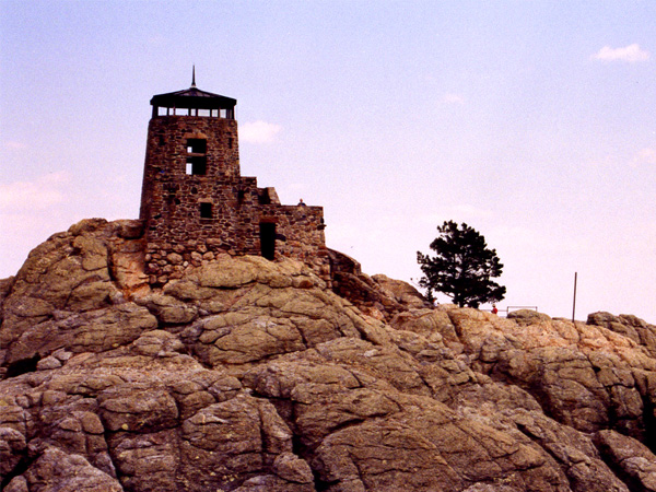
The peak's fire lookout tower and the staircase leading to it, as well as a nearby dam and pumphouse, were listed on the National Register of Historic Places in 1983.[10]
Hiŋháŋ Káǧa
This peak was called Hiŋháŋ Káǧa, or, "Owl maker," after rock formations that look like owls[11] (and the association of owls with impending death by the Lakota Sioux).[12] They dominated this region and occupied the territory at the time of European colonization. They considered it a sacred site within the Black Hills, which they call Pahá Sápa and Ȟé Sápa.[12]
The mountain was named Harney Peak in 1855 by American Lieutenant Gouverneur K. Warren in honor of US General William S. Harney, his commander in a regional military expedition. In punitive retaliation for other Sioux raids, in September 1855 Harney's forces killed Brulé Sioux warriors, women and children in what Americans called the Battle of Blue Water Creek in Garden County, Nebraska.[7]
Harney later commanded the United States military in the Black Hills area in the late 1870s.[13] The Lakota had tried to get the name of the peak changed for 50 years,[14] as Harney had massacred their people.[15]
In 2014 the Sioux renewed their effort to get the name changed, in an effort led by Basil Brave Heart of the Pine Ridge Indian Reservation. A Korean War veteran, he felt that Harney had not honored the military with his action.[7][15]
Some Lakota requested state officials in 2015 to reinstate their original name Hinhan Kaga for the peak. The Lakota Council of the Pine Ridge Reservation and descendants of Black Elk, a noted medicine man, supported naming it for him, as the national wilderness area around the peak is named for the shaman.[14]
He became known beyond the Lakota in part through the book Black Elk Speaks (1932), written by John G. Neihardt from long talks with the shaman.[16][17] South Dakota Governor Dennis Daugaard opposed the name change, as did other state officials, and no action was taken in 2015.[citation needed]
The U.S. Board on Geographic Names officially changed the mountain's name from "Harney Peak" to "Black Elk Peak" on August 11, 2016, by a unanimous vote of 12–0, with one abstention.[7][13] On August 18, 2016, Gov. Daugaard announced that the state would accept the new name.[18]
History
Harney Peak Lookout Tower, Dam, Pumphouse and Stairway | |
U.S. National Register of Historic Places | |
 Fire tower at Black Elk Peak | |
| Nearest city | Custer, South Dakota |
|---|---|
| Area | 4 acres (1.6 ha) |
| Built | 1935–1938 |
| Built by | Civilian Conservation Corps |
| NRHP reference No. | 83003019[10] |
| Added to NRHP | March 10, 1983 |
Black Elk Peak and the Black Hills were protected within the Great Sioux Reservation established by the United States government in the Treaty of Fort Laramie in 1868; it covered most of the territory west of the Missouri River in South Dakota (the area now called West River). American settlement was concentrated east of the river, where there was more water for farming.
The first Americans believed to have reached the summit were a party led by General George Armstrong Custer in 1874, during the Black Hills expedition. The federal government took back the Black Hills and another strip of land in a new treaty in 1877. More than a decade later, it broke up the Great Sioux Reservation in 1889 into five smaller reservations, the same year that North Dakota and South Dakota were admitted as states to the Union. The government made some nine million acres of former Lakota land available for purchase for ranching and homesteading. Most American settlement in West River did not start until the early 20th century. The area attracted many European immigrants as well as migrants from the East.
Black Elk Peak is the site where Black Elk (Lakota Sioux) received his "Great Vision" when nine years old. He later became a medicine man known for his wisdom. Late in life, he returned to the peak accompanied by writer John Neihardt. Black Elk was sharing much of his life and philosophy with Neihardt through long talks translated by his son. Neihardt tried to express the medicine man's wisdom in his book Black Elk Speaks (1932).[note 1]
Neihardt recorded Black Elk's words about his vision as follows:
"I was standing on the highest mountain of them all, and round about beneath me was the whole hoop of the world," he is quoted as saying. "And while I stood there I saw more than I can tell and I understood more than I saw; for I was seeing in a sacred manner the shapes of all things in the spirit, and the shape of all shapes as they must live together like one being."[19]
American settlers used Black Elk Peak as a fire lookout tower in 1911, with a wood crate placed at the summit for a seat. In 1920, a 12'x12' wood structure was built, and it was expanded to 16'x16' the following year. The federal Civilian Conservation Corps enlisted local men and completed construction of a stone fire tower in 1938, one of numerous projects in the state during the Great Depression. The Harney Peak fire tower was last staffed in 1967.[20]
A United States post office was operated at Black Elk Peak from 1936 until 1942, and again from 1945 until 1946.[21] The Harney Peak post office was reportedly one of the "most elevated post offices in the United States".[22]
A manmade dam was also created on the peak in 1935. This concrete reservoir holds 5,000 US gallons (19,000 l; 4,200 imp gal) of water; a pumphouse was added in 1938. In 1982, the lookout tower and its stairway, dam, and pumphouse were nominated by the USDA Forest Service for inclusion in the National Register of Historic Places. The Forest Service cited the site's cultural, recreational, and architectural significance to South Dakota.[23] On March 10, 1983, the site was officially added to the register.[10]
In May 2015 the South Dakota Board of Geographic Names recommended renaming Harney Peak as Hinhan Kaga, to remove the name of a commander known for massacring Sioux women and children at the Battle of Blue Water Creek [24] and to honor the original Lakota name for the mountain.[11] At the end of the following month, the board reversed the recommendation that the peak be renamed saying that "there was no public consensus on a new name."[24] The Lakota were divided on a preferred name, and Republican Governor Dennis Daugaard and some other Americans opposed any name change.[7]
The recommendation for renaming went to the federal US Board on Geographic Names.[25] The federal board acknowledged that the name was of concern to the Lakota, and its spokesman said, "In this case, the board felt that the name was derogatory or offensive, being that it was on a holy site of the Native Americans."[7] In a decision published August 11, 2016, the United States Board on Geographic Names adopted the name "Black Elk Peak."[26]
Hiking

The summit can be reached from Sylvan Lake, Camp Remington, Highway 244, Palmer Creek Rd., Mount Rushmore, or Horse Thief Lake. From the trailhead at Sylvan Lake in Custer State Park, to the summit and back is about 7 miles (11 km).[5] This is the shortest, least strenuous, and most popular route. No permit is required for use of the trail. However, A South Dakota State Parks pass is required to access the Sylvan Lake trailhead.
An old stone tower, once used as a fire lookout tower, is located at the summit. The ashes of Valentine McGillycuddy were interred near the base of the tower and a plaque reads, "Valentine McGillycuddy, Wasicu Wakan." Wasicu Wakan is Lakota for "Holy White Man."[27]
Gallery
 Granite Knob and Harney's Peak, by William H. Illingworth, 1874
 View from the top of the Black Elk Peak lookout tower.
 Fire lookout tower at the summit.
 A Mountain goat near the top of Black Elk Peak.
 A man-made dam is located near the summit.
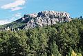 Black Elk Peak from Palmer Gulch (August 2006)
 Aerial view of Black Elk Peak and surrounding area


See also
- List of U.S. states by elevation
- List of mountains in South Dakota
Notes
- See chapter 3 and the Author's Postscript of Black Elk Speaks, Bison Books, 2004.
References
- "Harney". NGS Data Sheet. National Geodetic Survey, National Oceanic and Atmospheric Administration, United States Department of Commerce. Retrieved 2008-11-08.
- "Harney Peak, South Dakota". Peakbagger.com. Retrieved 2008-12-29.
- McGillycuddy and party had the first recorded ascent, though sources call him the first non-native or the first white man to climb the mountain. See Cerney, Jan; Sago, Roberta (2011). Black Hills National Forest: Harney Peak and the Historic Fire Lookout Towers. Arcadia. ISBN 978-1439625729. and "At the Highest Point". Black Hills Visitor. 2017-08-25. Retrieved 2019-08-15..
- James R. Macdonald, Ph.D. (2009). "Museum of Geology: History". Rapid City, South Dakota: South Dakota School of Mines & Technology. Retrieved 2012-11-10.
- "Harney Area Trailheads". South Dakota Fish, Game and Parks. Retrieved 2012-11-10.
- Mount Rushmore, South Dakota, 30x60 Minute Topographic Quadrangle, USGS, 1977
- David Rooks, "Breaking: Black Elk Peak Soars Above The He Sapa, No Longer Harney Peak" Archived 2016-08-12 at the Wayback Machine, Indian Country Today, 12 August 2016; accessed 12 August 2016
- Jerry Penry. "Harney Peak's Elevation". Retrieved 2016-12-19.
- Tupper, Seth (2016-12-26). "How South Dakota's high point ended up shorter than thought". Rapid City Journal. Retrieved 2016-12-26.
- "National Register Information System". National Register of Historic Places. National Park Service. November 2, 2013.
- Carrie Moore (2015). "Hill City Prevailer-News". Hill City Prevailer-News. Archived from the original on 2015-10-18. Retrieved 2015-06-04.
- Steve Russell, "Names Have Power: Denali and Other Colonist Lies" Archived 2016-11-14 at the Wayback Machine, Indian Country Today, 4 September 2015; accessed 4 November 2016
- "Black Elk Peak". Geographic Names Information System. United States Geological Survey, United States Department of the Interior. Retrieved 11 August 2016.
- Stu Whitney, "Whitney: In defense of Black Elk Peak", Argus Leader, 12 August 2016; accessed 15 August 2016
- David Rooks, "Black Elk Peak ‘Answer to Many Prayers’: Basil Brave Heart" Archived 2016-08-17 at the Wayback Machine, Indian Country Today, 15 August 2016; accessed 15 August 2016
- Nord, James (May 1, 2015). "Activists work for Native American-friendly site names". The Elkhart Truth. Associated Press.[permanent dead link]
- Louwagie, Lacey (July 6, 2015). "Despite Objections, 'Harney Peak' Name Stays". Courthouse News Service.
- Tupper, Seth (19 August 2016). "Gov: State won't fight Harney rename". Rapid City Journal. pp. A1.
- "Harney Peak". SouthDakota.com. Retrieved 2012-11-10.
- Saum, Bradley D. (2013). Harney Peak Revealed. Createspace. pp. 34–36. ISBN 9781478316756.
- U.S. Geological Survey Geographic Names Information System: Harney Peak Post Office (historical)
- Federal Writers' Project (1940). South Dakota place-names, v.1–3. American guide series. University of South Dakota. p. 40.
- Reetz, Terrell W. (January 8, 1982). "National Register of Historic Places Inventory/Nomination: Harney Peak Lookout Tower, Dam, Pumphouse and Stairway". National Park Service. Retrieved February 12, 2022. With accompanying pictures
- South Dakota Board of Geographic Names (2015). "Harney Peak Written Public Comments" (PDF). South Dakota Board of Geographic Names. Archived from the original (PDF) on 2015-07-15. Retrieved 2015-06-04.
- "In Reversal, SD Board Would Keep Harney Peak Name". Pierre, SD: Associated Press. 29 June 2015. Retrieved 14 July 2015.
- Nord, James (11 August 2016). "Feds Rename South Dakota's Highest Peak to Black Elk Peak". ABC News. Retrieved 11 August 2016.
- "McGillycuddy House at the heart of city history". Retrieved 2012-11-12.
External links
- Regenold, Stephen (2008-04-02). "High in the Black Hills, as Seasons Turn". The New York Times.
- "Facts About Harney Peak". Climbing.About.com.
Highest natural points of U.S. states and additional U.S. areas | ||
|---|---|---|
| ||
| Additional U.S. areas |
| |
National Register of Historic Places in Pennington County, South Dakota | |||||||||||
|---|---|---|---|---|---|---|---|---|---|---|---|
| National Historic Site |  | ||||||||||
| Districts |
| ||||||||||
| Buildings |
| ||||||||||
| Objects |
| ||||||||||
| Sites |
| ||||||||||
| Structures |
| ||||||||||
| Footnotes | ‡This historic property also has portions in an adjacent county. † This entry has been removed from the registry. | ||||||||||
See also: National Register of Historic Places listings in Pennington County, South Dakota and List of National Historic Landmarks in South Dakota | |||||||||||
Authority control | |
|---|---|
| General |
|
| National libraries | |
На других языках
[de] Black Elk Peak
Der Black Elk Peak (früher Harney Peak) bildet mit seinen 2208 m den höchsten Punkt des US-Bundesstaates South Dakota und der Black Hills. Er befindet sich im Pennington County und ist der höchste Berg der Vereinigten Staaten östlich der Rocky Mountains.- [en] Black Elk Peak
[fr] Pic Black Elk
Le pic Black Elk, en anglais Black Elk Peak, anciennement (jusqu'en août 2016) pic Harney, est la montagne la plus haute (2 207 mètres) de l’État américain du Dakota du Sud. Elle se situe dans la chaîne montagneuse des Black Hills. Il s’agit du point le plus élevé à l’est des montagnes Rocheuses dans le centre du pays. Une tour d’observation abandonnée se loge à son sommet.[ru] Блэк-Элк-Пик
Блэк-Элк-Пик (до 2016 года — Харни-Пик) — гора, высшая точка Южной Дакоты, расположена в массиве Блэк-Хилс, имеет высоту 2207 м. Является высшей точкой США к востоку от Скалистых гор и высшей точкой массива Блэк-Хилс.Другой контент может иметь иную лицензию. Перед использованием материалов сайта WikiSort.org внимательно изучите правила лицензирования конкретных элементов наполнения сайта.
WikiSort.org - проект по пересортировке и дополнению контента Википедии