geo.wikisort.org - Mountains
Boundary Peak is a mountain in Esmeralda County, Nevada, United States. With a peak elevation of 13,147 feet (4,007 m), it is the highest natural point in the state of Nevada.[2]
| Boundary Peak | |
|---|---|
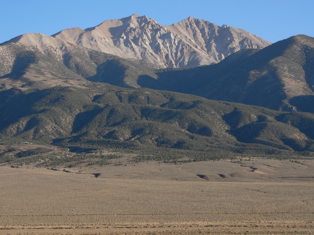 Boundary Peak as seen from Benton. Boundary is on the left (east), while connecting to higher Montgomery Peak on the right (west). | |
| Highest point | |
| Elevation | 13,147 ft (4,007 m) NAVD 88[1] |
| Prominence | 253 ft (77 m)[2] |
| Listing |
|
| Coordinates | 37°50′46″N 118°21′05″W[1] |
| Geography | |
 Boundary Peak Esmeralda County, Nevada, U.S. | |
| Parent range | White Mountains |
| Topo map | USGS Boundary Peak |
| Geology | |
| Age of rock | Cretaceous |
| Mountain type | Quartz monzonite |
| Climbing | |
| Easiest route | Scramble, class 2[3] |
Geography
Boundary Peak is the northernmost peak of 13,000 feet or greater elevation within the White Mountains. The summit is located in Esmeralda County of southwestern Nevada, and is within the Boundary Peak Wilderness of the Inyo National Forest. It is less than half a mile (1 km) from the California state line, which is how it derived its name.[4]
While it is the highest point in Nevada, the considerably taller Montgomery Peak (13,441 feet or 4,097 metres) is less than 1 mi (1.6 km) away, across the state line in California. By most definitions Boundary Peak, which has a prominence of only 253 ft (77 m), is considered to be a sub-peak of Montgomery Peak.
Boundary Peak is only 82 feet (25 m) taller than Wheeler Peak, which is located in Great Basin National Park, White Pine County in eastern Nevada. By most definitions, Wheeler Peak is the tallest independent mountain within Nevada.
Climbing
This peak is most often climbed from the Nevada side. From there, a climber may scramble the ridge connecting to Montgomery Peak. It is recommended that the U.S. Forest Service (Inyo National Forest) be contacted so they can provide climbing information.

See also
 Geography portal
 United States portal
 Mountains portal
- List of highest points in Nevada by county
- List of U.S. states by elevation
References
- "Boundary". NGS Data Sheet. National Geodetic Survey, National Oceanic and Atmospheric Administration, United States Department of Commerce. Retrieved 2008-04-03.
- "Boundary Peak, Nevada". Peakbagger.com. Retrieved 2008-04-03.
- "Desert Peaks Section List" (PDF). Angeles Chapter, Sierra Club.
- Federal Writers' Project (1941). Origin of Place Names: Nevada (PDF). W.P.A. p. 31.
External links
- "Boundary Peak". Geographic Names Information System. United States Geological Survey, United States Department of the Interior. Retrieved 2008-11-21.
- Inyo National Forest: Boundary Peak Wilderness Area.
Highest natural points of U.S. states and additional U.S. areas | ||
|---|---|---|
| ||
| Additional U.S. areas |
| |
This Esmeralda County, Nevada state location article is a stub. You can help Wikipedia by expanding it. |
На других языках
[de] Boundary Peak (Nevada)
Boundary Peak (deutsch Grenzspitze) an der Grenze zu Kalifornien ist Teil der White Mountains und der höchste Gipfel des US-Bundesstaats Nevada.[1] Die Sierra Nevada beginnt nur 50 Kilometer westlich des Boundary Peak. Die Wildnis um den Berg wird durch die Boundary Peak Wilderness Area geschützt.[2] Der Berg liegt auf dem Gebiet des Inyo National Forest. Im Umkreis wachsen Langlebige Kiefern.- [en] Boundary Peak (Nevada)
[es] Pico Boundary (Nevada)
Boundary Peak es el punto más alto del estado de Nevada (Estados Unidos), con 4007 metros de altitud, localizado en el condado de Esmeralda. Se ubica totalmente dentro del estado de Nevada, aunque está a menos de 1 km de la frontera con California.[fr] Pic Boundary
Le pic Boundary, en anglais Boundary Peak, est un sommet des montagnes Blanches dans le Nevada, à l'ouest des États-Unis ; il culmine à 4 007 mètres d'altitude et constitue le plus haut sommet de l'État. Il se trouve à moins d'un kilomètre de la frontière avec la Californie, dans le comté d'Esmeralda. Le pic Montgomery (4 097 mètres) appartient à la même chaîne mais se trouve en Californie. La région entourant le sommet appartient à la réserve naturelle de Boundary Peak Wilderness Area.Другой контент может иметь иную лицензию. Перед использованием материалов сайта WikiSort.org внимательно изучите правила лицензирования конкретных элементов наполнения сайта.
WikiSort.org - проект по пересортировке и дополнению контента Википедии