geo.wikisort.org - Mountains
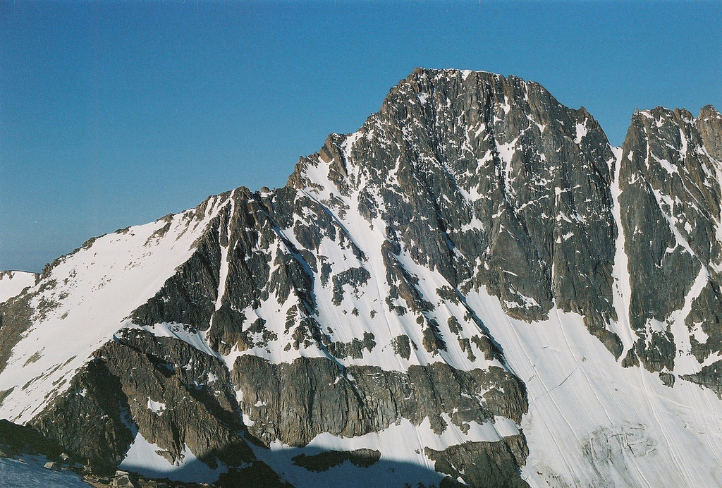
Granite Peak, at an elevation of 12,807 feet (3,904 m) above sea level,[1] is the highest natural point in the U.S. state of Montana, and the tenth-highest state high point in the nation.[3] It lies within the Absaroka-Beartooth Wilderness in Park County, very near the borders of Stillwater County and Carbon County. Granite Peak is 10 miles (16 km) north of the Wyoming border and 45 miles (72 km) southwest of Columbus, Montana.
| Granite Peak | |
|---|---|
 | |
| Highest point | |
| Elevation | 12,807 ft (3,904 m) NAVD 88[1] |
| Prominence | 4,759 ft (1,451 m)[2] |
| Listing | U.S. state high point 10th |
| Coordinates | 45°09′48″N 109°48′27″W[1] |
| Geography | |
 Granite Peak Park County, Montana, U.S. | |
| Parent range | Beartooth Mountains |
| Topo map | USGS Granite Peak |
| Climbing | |
| First ascent | 1923 by Elers Koch |
| Easiest route | Southwest Couloir (class 3 scramble) |
Granite Peak is often considered the second most difficult state high point to climb after Denali in Alaska, due to technical climbing, poor weather, and route finding.[4][5] Granite Peak's first ascent was made by Elers Koch, James C. Whitham, and R.T. Ferguson on August 29, 1923, after several failed attempts by others. It was the last of the state high points to be climbed.[5] Today, climbers typically spend two or three days ascending the peak, stopping over on the Froze-to-Death Plateau, although some climbers choose to ascend the peak in a single day. Another route that has gained popularity in recent years is the Southwest Couloir route, a non-technical route from the south starting near Cooke City; climbers generally take two days to complete it.
See also
 Geography portal
 Mountains portal
- List of mountains in Montana
- List of U.S. states by elevation
References
- "Granite Peak". NGS Data Sheet. National Geodetic Survey, National Oceanic and Atmospheric Administration, United States Department of Commerce.
- "Granite Peak, Montana". Peakbagger.com. Retrieved 2008-12-13.
- "Elevations and Distances in the United States". United States Geological Survey. April 29, 2005. Retrieved 2020-08-04.
- "Granite Peak, Montana". SummitPost.org. Retrieved 2012-11-10.
- Winger, Charlie; Winger, Diane (2002). Highpoint Adventures: The Complete Guide to the 50 State Highpoints. Colorado Mountain Club Press. pp. 140–141.
External links
Granite Peak (Montana)
- "Granite Peak". United States Forest Service.
- "Granite Peak". Geographic Names Information System. United States Geological Survey, United States Department of the Interior.
- "Friends of Granite Peak". Archived from the original on 2007-08-07. Retrieved 2019-05-29, An organization dedicated to preserving the natural beauty of Granite Peak in Montana.
Highest natural points of U.S. states and additional U.S. areas | ||
|---|---|---|
| ||
| Additional U.S. areas |
| |
This Park County, Montana state location article is a stub. You can help Wikipedia by expanding it. |
На других языках
[de] Granite Peak
Der Granite Peak ist ein Berg in den Beartooth Mountains, einer Bergkette der Rocky Mountains in Montana, Vereinigte Staaten. Mit 3904 m[1] Höhe ist er der höchste Punkt Montanas.- [en] Granite Peak (Montana)
[es] Pico Granito
El pico Granito (en inglés: Granite Peak), con una altitud de 3904 metros sobre el nivel del mar, es el punto más alto del estado de Montana (Estados Unidos). Está situado en el condado de Park muy cerca de la frontera con el condado de Stillwater y el condado de Carbon. El pico Granito está a 16 km al norte de la frontera de Montana con Wyoming y a 72 km al suroeste de la ciudad de Columbus (Montana).[fr] Pic Granite
Le pic Granite, Granite Peak en anglais, est un sommet des monts Beartooth, dans le comté de Park au Montana, aux États-Unis. Avec 3 901 mètres d'altitude, c'est le point culminant de l'État du Montana, lui-même dixième État le plus haut des États-Unis.[ru] Гранит-Пик (Монтана)
Гранит-Пик (англ. Granite Peak) — гора в штате Монтана.Другой контент может иметь иную лицензию. Перед использованием материалов сайта WikiSort.org внимательно изучите правила лицензирования конкретных элементов наполнения сайта.
WikiSort.org - проект по пересортировке и дополнению контента Википедии