geo.wikisort.org - Mountains
Timms Hill or Timm's Hill is the highest natural point in the U.S. state of Wisconsin.[3] Located in north-central Wisconsin in Timms Hill County Park in the Town of Hill in Price County, After being surveyed by Quentin Stevens of Ogema Telephone Co in 1962, Timms Hill was discovered to have an elevation of 1,951.5 ft (595 m). It is less than 1 mile (1.6 km) south of Highway 86, about midway between Ogema and Spirit and about 23 miles (37 km) west of Tomahawk.[4]
| Timms Hill | |
|---|---|
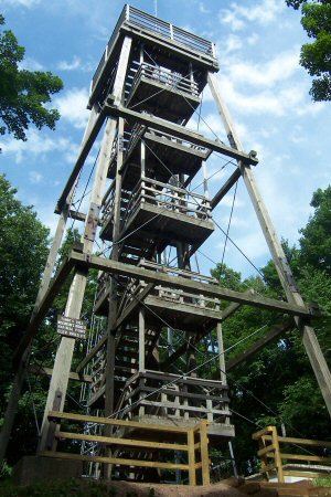
 Timms Hill, Wisconsin, July 2014. | |
| Highest point | |
| Elevation | 1,951.5 ft (594.8 m)[1] |
| Prominence | 425 ft (130 m)[2] |
| Listing | U.S. state high point 39th |
| Coordinates | 45°27′03″N 90°11′43″W[1] |
| Geography | |
 Timms Hill Wisconsin | |
| Location | Price County, Wisconsin, US |
| Topo map | USGS Timms Hill |
| Climbing | |
| Easiest route | Hike |
Description
Timms Hill is located in Timms Hill County Park. A public lookout tower is atop the hill. Visible to the southeast is Rib Mountain (elev. 1,924 ft, 586 m), 44 miles away by line of sight.[5] The 10-mile (16 km) Timms Hill Trail connects to the Ice Age Trail,[6] a National Scenic Trail stretching 1,200 miles (1,900 km) across glacial terrain in Wisconsin.
See also
- List of U.S. states by elevation
References
- "Ogema". NGS Data Sheet. National Geodetic Survey, National Oceanic and Atmospheric Administration, United States Department of Commerce. Retrieved 2010-01-26.
- "Timms Hill, Wisconsin". Peakbagger.com. Retrieved 2012-10-17.
- "Timms Hill (Wisconsin)". Geographic Names Information System. United States Geological Survey, United States Department of the Interior.
- Department of Transportation-Price County
- "Timms Hill, Wisconsin's highest natural point". State Trunk Tour. 2015-12-27. Retrieved 2021-04-05.
- Timm's Hill Trail Web Site
External links
- "Timms Hill". Geographic Names Information System. United States Geological Survey, United States Department of the Interior. Retrieved 2008-12-18.
- "Timms Hill, WI". TopoQuest Topographic Map Viewer. Retrieved 2008-12-18.
- "Timms Hill". SummitPost.org. Retrieved 2008-12-18.
- "Timms Hill Trail, WI". website. Retrieved 2018-01-03.
Highest natural points of U.S. states and additional U.S. areas | ||
|---|---|---|
| ||
| Additional U.S. areas |
| |
На других языках
[de] Timms Hill
Der Timms Hill, oder auch Timm’s Hill, ist mit seinen 595 Metern die höchste Erhebung des Price County und des US-Bundesstaates Wisconsin. Er liegt im Timms Hill County Park, einem nach ihm benannten, kleinen Naturpark, welcher als Erholungsgebiet dient. Auf seinem Gipfel befindet sich eine hölzerne Aussichtswarte, welche früher als Feuerausblicksturm diente.- [en] Timms Hill
[fr] Timms Hill
Timms Hill est le point culminant de l'État du Wisconsin, avec une altitude de 595 mètres.[ru] Тиммс-Хилл
Тиммс-Хилл — высшая точка американского штата Висконсин. Расположена в северно-центральной части штата в городе Хилл. Высота составляет 594,8 метра.[1]Другой контент может иметь иную лицензию. Перед использованием материалов сайта WikiSort.org внимательно изучите правила лицензирования конкретных элементов наполнения сайта.
WikiSort.org - проект по пересортировке и дополнению контента Википедии