geo.wikisort.org - Mountains
Cerro de Punta or just Cerro Punta is the highest peak in Puerto Rico, rising to 1,338 meters (4,390 ft) above sea level.[note 1] The mountain is part of the Cordillera Central and is located in the municipality of Ponce.[3][4][5][1][6]
| Cerro de Punta | |
|---|---|
 Cerro de Punta as seen from Museo de Arte de Ponce, Ponce, Puerto Rico | |
| Highest point | |
| Elevation | 4,390 ft (1,340 m)[1] |
| Prominence | 4,390 ft (1,340 m) |
| Listing |
|
| Coordinates | 18°10′21″N 66°35′31″W[2] |
| Geography | |
 Cerro de Punta Location in Puerto Rico | |
| Location | Ponce, Puerto Rico |
| Parent range | Cordillera Central |
| Climbing | |
| Easiest route | PR-143 |
Location
The mountain is part of the Cordillera Central and is located on the border between the municipalities of Jayuya and Ponce.[7][8][9][2] The access road to the point closest to the highest elevation is from the municipality of Jayuya.[10] It is part of the Toro Negro Forest Reserve, and it has been described as "an alpine runt."[11] It is located on the western end of the Toro Negro State Park. The mountain is just north of east-to-westbound Route 143. It is located at coordinates 18.172458 and -66.591839W. The nearest populated place to Cerro de Punta is Urbanización Vega Linda, located 3.3 miles (5.3 km) away.
Geology
Unlike many Caribbean mountains, Cerro de Punta is not a volcano but simply the highest point in the Cordillera Central. Cordillera Central is the central mountain range that divides the island by running in an east-west fashion.[12]
Best view
The view from atop Cerro de Punta is said to be "the best view in all of Puerto Rico". On a clear day, it is possible to see virtually the entire island, including as far as San Juan, which is over 75 miles (120 km) away.[12] There are a number of radio and television transmission and re-transmission towers just off the top of the mountain.[13] There is an observation platform at the top of the mountain.[14]
Wildlife and flora
The mountain is home to an abundant amount of wildlife, lush vegetation, flowering shrubs and trees, and numerous waterfalls.[15] The mountain is covered by Sierra palm trees.[13] Various plants, including some endangered species are found here,[16] such as the endangered fern Elaphoglossum serpens which is found only on this mountain and nowhere else in the world,[17] and Cook's holly (Ilex cookii) or planta de te, which is only found here and in neighboring Mount Jayuya.[18]
Nearby roads
The area consists of many steep mountains. The nearest road is PR-143, which is a winding two-lane mountain road that must be travelled very slowly as it is not possible to see traffic coming from the opposite direction for any significant length. Off Route 143 is the road that actually leads to the mountain's top. Route 143 can be accessed via the better-traveled Route 10.[13] Route 143 is part of the Ruta Panorámica.[19]
 Driving in mountain roads tips
 View of roadway from Cerro de Punta


Hiking and access trail
A nearby inn called Hacienda Gripiñas, has a trail that leads to the top of the mountain. Hacienda Gripiñas was a coffee plantation, but has been turned into a country inn. It actually still grows some coffee. The inn operates under a contract with the Government of Puerto Rico.[12] The trails, however, are not well marked and often suffer damage from storms.[12] While people can hike their way to the top of the mountain, there is a paved road that leads to the very summit.[11] The Toro Negro State Forest has 12 miles (19 km) of hiking trails some of which lead to the top of Cerro de Punta.[11]
| Cerro Puntas (Climate - Sub-Tropical Highland (Cfb)) | ||||||||||||||||||||||||||||||||||||||||||||||||||||||||||||
|---|---|---|---|---|---|---|---|---|---|---|---|---|---|---|---|---|---|---|---|---|---|---|---|---|---|---|---|---|---|---|---|---|---|---|---|---|---|---|---|---|---|---|---|---|---|---|---|---|---|---|---|---|---|---|---|---|---|---|---|---|
| Climate chart (explanation) | ||||||||||||||||||||||||||||||||||||||||||||||||||||||||||||
| ||||||||||||||||||||||||||||||||||||||||||||||||||||||||||||
| ||||||||||||||||||||||||||||||||||||||||||||||||||||||||||||
Gallery
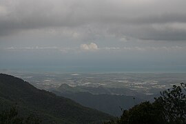 View from Cerro de Punta, highest point in Puerto Rico
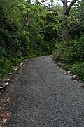 Paved road for climbing up to Cerro de Punta
 Antennas at Cerro de Punta
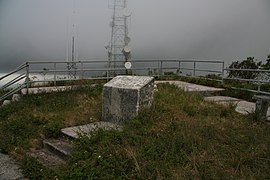 Lookout area at Cerro de Punta's summit
 Cerro de Punta as seen from Mercedita Airport, Ponce, Puerto Rico
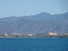 Cerro de Punta as seen from Caja de Muertos, Ponce, Puerto Rico
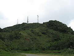 Cerro de Punta as viewed from Ruta Panorámica


See also
- List of mountain peaks of the Caribbean
- List of mountain peaks of the United States
- List of U.S. states by elevation
Notes
- As of February, 1981, the US Geological Survey reports the height as 1,328 meters. (See: Geographic Names Information System: Feature Query Results. United States Geological Survey. 13-FEB-1981. Retrieved 22 August 2013.) However, Gousha (1995) and Metrodata (1998) report the height as 1,338 meters. (See: Las cumbres más altas de Puerto Rico. Archived 2015-01-28 at the Wayback Machine Universidad Interamericana de Puerto Rico en Bayamon. Departamento de Ciencias Naturales y Matematicas. Retrieved 22 August 2013.)
References
- "Elevations and Distances in the United States". U.S. Geological Survey. 29 April 2005. Retrieved 9 November 2006.
- "Cerro de Punta". Geographic Names Information System. United States Geological Survey, United States Department of the Interior. Retrieved 25 January 2015.
- Government of the Commonwealth of Puerto Rico. Office of Management and Budgeting. Government Information and Technology Area. Geographic Information Systems Unit. General Purpose Population Data, Census 2000. Archived 2010-08-12 at the Wayback Machine Retrieved March 21, 2010.
- Ponce Topographic Map. Map Styles: Map and Shaded. Trails.com. From: United States Geological Survey. Topo Map. Projection: NAD83/WGS84. Retrieved February 22, 2010.
- Puerto Rico Physical Features: Summits. PR Home Town Locator. United States Geological Survey. Retrieved 7 June 2011.
- Science In Your Backyard: Puerto Rico: Puerto Rico State Facts. U.S. Geological Survey. Retrieved March 21, 2010. Archived.
- EPRL, Publicado por Grupo Editorial (9 June 2016). "Municipio de Ponce - Municipios". EnciclopediaPR (in Spanish). Retrieved 22 August 2019.
- EPRL, Grupo Editorial (9 June 2016). "Ponce Municipality - Municipalities". EnciclopediaPR. Retrieved 22 August 2019.
- Nueva Geografia de Puerto Rico: fisica, economica y social. Rafael Pico. 1975.
- Government of Puerto Rico. General Purpose Population Data, Census 2000. Unidad de Sistemas de Información Geográfica, Área de Tecnología de Información Gubernamental, Oficina de Gerencia y Presupuesto. Archived 2010-08-12 at the Wayback Machine Retrieved March 21, 2010.
- O'Keefe, M. Timothy. "Cerro de Punta Climb, Puerto Rico, Part 1". Guide To Caribbean Vacations. Retrieved 25 January 2015.
- "Cerro de Punta: the High Point of Puerto Rico". The Puerto Rico Channel. Retrieved 25 January 2015.
- Brandon Stephens, Marion Smith, and Alan Cressler. Cerro de Punta. Published by Brian Killingbeck. ©2005. Archived 2013-05-30 at the Wayback Machine
- "Planetware: Your Unlimited Travel Guide to the World". Archived from the original on 12 October 2008. Retrieved 15 June 2019.
- The Puerto Rico Channel. Cerro de Punta:the High Point of Puerto Rico.
- Maxon & Morton ex Maxon. U.S. Department of Agriculture. Elaphoglossum serpens At Cerro de Punta, Jayuya.
- USFWS. Recovery Plan for Puerto Rican Endangered Ferns (7 spp.). January 1995.
- Group), Sara Oldfield (Co-Chair IUCN SSC Global Tree Specialist (20 August 2018). "IUCN Red List of Threatened Species: Ilex cookii". IUCN Red List of Threatened Species.
- "Cerro de Punta". Atlas Obscura. Retrieved 15 June 2019.
- "San Juan, PR Climate Data" [Adjuntas Normals]. National Weather Service Weather Forecast Office. Retrieved 18 April 2011.
External links
- Cerro de punta photos from Panoramio
- (Spanish) Official website from the municipality of Jayuya
- Cerro de Punta Climb, Puerto Rico. (A climber's Dairy)
Ponce, Puerto Rico | ||
|---|---|---|
| ||
| Barrios |
|  |
| Beaches |
| |
| Museums |
| |
| Hotels |
| |
| Events |
| |
| Theaters |
| |
| Parks |
| |
| Hospitals |
| |
| Universities |
| |
| Islands | ||
| Rivers | ||
| Mountains | ||
На других языках
[de] Cerro de Punta
Der Cerro de Punta ist mit 1338 m der höchste Berg in dem US-amerikanischen Außengebiet Puerto Rico. Er ist Teil der Gebirgskette Cordillera Central. Der Berg liegt auf dem Gebiet der Gemeinde Ponce.[1]- [en] Cerro de Punta
[es] Cerro de Punta
El Cerro de Punta (también conocido como Cerro Puntita) es el pico más alto de Puerto Rico con una altura de 1338 m sobre el nivel del mar. El pico de Cerro de Punta se encuentra en el municipio de Ponce,[1][2][3][4][5][6] mientras que la montaña misma es compartida con el municipio de Jayuya. La montaña está situada en la Cordillera Central. La temperatura promedio es de 65ºF (18ºC) con vientos que siempre soplan con gran fuerza, los cuales se pueden sentir con sensaciones térmicas bajo el punto de congelación durante el invierno.[fr] Cerro de Punta
Le cerro de Punta, ou cerro Punta, est une montagne de Porto Rico et le point culminant de l'île. Elle s'élève à une altitude de 1 338 mètres, sur le territoire de la commune de Ponce, dans la cordillère Centrale.[it] Cerro de Punta
Il Cerro de Punta, conosciuto anche come Cerro Puntita, con i suoi 1.338 m è il monte più alto di Porto Rico. Fa parte della catena montuosa della Cordillera Central, ed è localizzato nel comune di Ponce.Другой контент может иметь иную лицензию. Перед использованием материалов сайта WikiSort.org внимательно изучите правила лицензирования конкретных элементов наполнения сайта.
WikiSort.org - проект по пересортировке и дополнению контента Википедии