geo.wikisort.org - Mountains
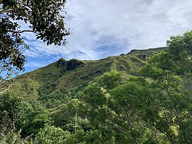
Mount Lamlam (meaning lightning in Chamoru) is a peak on the United States island of Guam. It is located near the village of Agat (5 km or 3 mi[3] north), in the south-west of the island.
| Mount Lamlam | |
|---|---|
 | |
| Highest point | |
| Elevation | 1,332 ft (406 m)[1] |
| Prominence | 1,332 ft (406 m) |
| Coordinates | 13°20′19″N 144°39′46″E[2] |
| Geography | |
| Location | Near Agat, Guam, Micronesia, U.S. territory |
| Topo map | USGS Agat |
| Climbing | |
| Easiest route | |
U.S. National Natural Landmark | |
| Designated | 1972 |
Rising to 406 meters (1,332 ft) above sea level, the distance from the peak to the bottom of the nearby Mariana Trench is said to be the greatest change in elevation on Earth over such a short distance.[4]
See also
- List of mountain peaks of the United States
- List of U.S. states by elevation
References
- "Highest Mountain Peaks in Guam". MountainZone.com
- "Mount Lamlam". Geographic Names Information System. United States Geological Survey, United States Department of the Interior.
- "Mount Lamlam". MountainZone.com
- One internet site Geography of Guam claims the difference is 37,820 feet (11,530 m). However, this is measured relative to the Challenger Deep, not the part of the trench adjacent to Guam.
- Bendure, G. & Friary, N. (1988) Micronesia:A travel survival kit. South Yarra, VIC: Lonely Planet.
External links
- "Mount Lamlam". PeakBagger.com
- "Mount LamLam". SummitPost.org
На других языках
- [en] Mount Lamlam
[es] Monte Lamlam
El monte Lamlam (en inglés: Mount Lamlam;[1] donde Lamlam significa "rayo" en chamorro) es un pico en la isla y territorio estadounidense de Guam. Está situado en el pueblo de Agat, en el suroeste de la isla. A 1332 pies (406 m), es el pico más alto en todo Guam. La distancia desde el pico hasta el fondo de la cercana fosa de las Marianas es el mayor cambio en la elevación en la Tierra en una distancia tan corta.[2][fr] Mont Lamlam
Le mont Lamlam est une montagne de Guam, le point culminant du territoire. Elle se situe à une altitude de 406 mètres près d'Agat.Текст в блоке "Читать" взят с сайта "Википедия" и доступен по лицензии Creative Commons Attribution-ShareAlike; в отдельных случаях могут действовать дополнительные условия.
Другой контент может иметь иную лицензию. Перед использованием материалов сайта WikiSort.org внимательно изучите правила лицензирования конкретных элементов наполнения сайта.
Другой контент может иметь иную лицензию. Перед использованием материалов сайта WikiSort.org внимательно изучите правила лицензирования конкретных элементов наполнения сайта.
2019-2025
WikiSort.org - проект по пересортировке и дополнению контента Википедии
WikiSort.org - проект по пересортировке и дополнению контента Википедии
