geo.wikisort.org - Mountains
Mount Shishaldin (/ʃɪˈʃældən/) is a moderately active volcano on Unimak Island in the Aleutian Islands chain of Alaska. It is the highest mountain peak of the Aleutian Islands. The most symmetrical cone-shaped glacier-clad large mountain on Earth, the volcano's topographic contour lines are nearly perfect circles above 6,500 feet (1,981 m). The lower north and south slopes are somewhat steeper than the lower eastern and western slopes. The volcano is the westernmost of three large stratovolcanoes along an east–west line in the eastern half of Unimak Island.
| Mount Shishaldin | |
|---|---|
 Mount Shishaldin, May 1994 | |
| Highest point | |
| Elevation | 9,373 ft (2,857 m) |
| Prominence | 9,373 ft (2,857 m) |
| Isolation | 877 km (545 mi) |
| Listing |
|
| Coordinates | 54°45′21″N 163°58′03″W |
| Geography | |
 Mount Shishaldin Unimak Island, Alaska, U.S. | |
| Parent range | Aleutian Range |
| Topo map | USGS False Pass D-6 |
| Geology | |
| Mountain type | Stratovolcano |
| Volcanic arc/belt | Aleutian Arc |
| Last eruption | January 3, 2020 |
| Climbing | |
| First ascent | May 16, 1932 by G. Peterson et al. (first recorded ascent) |
| Easiest route | East face:snow/glacier climb |
U.S. National Natural Landmark | |
| Designated | 1967 |
The upper 6,600 ft (2,012 m) is almost entirely covered by glacial snow and ice. In all, Shishaldin's glacial shield covers about 35 square miles (91 km2). It is flanked to the northwest by 24 monogenetic parasitic cones, an area blanketed by massive lava flows. The Shishaldin cone is less than 10,000 years old and is constructed on a glacially eroded remnant of an ancestral somma and shield. Remnants of the older ancestral volcano are exposed on the west and northeast sides at 4,900 to 5,900 ft (1,494 to 1,798 m) elevation. The Shishaldin edifice contains about 120 square miles (310 km2) of material. A very steady steam plume rises from its small summit crater which is about 500 ft (152 m) across and slightly breached along the north rim.
In 1967, Shishaldin Volcano was designated as a National Natural Landmark by the National Park Service.[1]
Name
The Aleuts named the volcano Sisquk[2] or Sisagux,[3] meaning "mountain which points the way when I am lost." The spelling Shishaldin comes from the Russian version, Шишалдина, of the Aleut name.[3]
Activity
This volcano has had many recorded eruptions during the 19th and 20th centuries, and a couple of reports of volcanic activity in the area during the 18th century may have referred to Shishaldin as well. Therefore, the volcano's entire recorded history is spotted with reports of activity. AVO has 24 confirmed eruptions at Shishaldin, making it the volcano with the third most confirmed eruptions (after Akutan and Pavlof). However, Shishaldin has the most eruptions (this means confirmed and possible eruptions) in Alaska, but half of the eruptions are unconfirmed. Recent, well-documented eruptions were in 1995–96 and 1999. Since the 1999 eruption, it has maintained seismic activity, typically having very low-magnitude volcanic earthquakes (most are below magnitude 1) every 1–2 minutes. During this period of non-eruptive seismic activity, it has been puffing steam, with puffs also occurring about every 1–2 minutes. There were reports in 2004 of small quantities of ash being emitted with the steam.
A new period of activity started in July 2019 with incandescence observed in the summit crater during a time of increased seismic activity. On July 23, an active lava lake and minor spattering within the summit crater was observed. A new lava effusion event began on October 13 advancing over the next several weeks. The summit cone partially collapsed on November 25, producing a pyroclastic flow down the northwest side of the volcano and a new lava flow. On December 12, a short-lived explosion from Shishaldin expelled an ash cloud to 20,000–25,000 feet (6,100–7,600 m). During late December, eruptive activity continued with lava flows and low-level explosive activity at the summit. On January 3, 2020, seismicity led to an ash cloud eruption that reached as high as 27,000 feet (8,200 m). Another large ash cloud was emitted on January 19, 2020. The lava flows emitted during the eruptive events have cut deep channels in the snow and ice mantle of the volcano's north slope.
The Alaska Volcano Observatory monitors the volcano for more hazardous activity with seismometers and satellite images. Due to the remote location of the volcano, visual observations are rare.
Climbing
The first recorded ascent of Shishaldin was in 1932, by G. Peterson and two companions. Given the straightforward nature of the climbing (Alaska Grade 1, snow up to 40 degree slope), it is possible that an earlier ascent occurred, either by native Aleuts, Russians, or other visitors. Shishaldin is a popular ski descent (6,000 ft (1,829 m) vertical) for local climbers (of whom there are few). Due to its remoteness, Shishaldin is not often climbed by outsiders.
Gallery
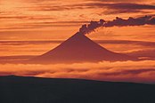 An image of the volcano at sunset from 2005
 A view of the volcano's 1999 eruption.
 Map showing volcanoes of Alaska Peninsula.
 An overhead view of the volcano from November 24, 2013
 Shishaldin and Isanotski Volcanoes.
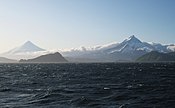 Shishaldin (left) and Isanotski volcanoes on Unimak Island.
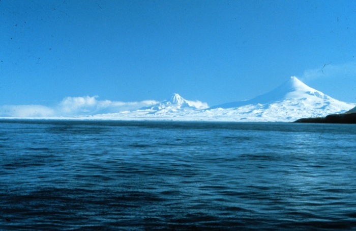
 Shishaldin Volcano on the west end of Unimak Island.


See also
- List of mountain peaks of North America
- List of Ultras of the United States
- List of volcanoes in the United States
Further reading
- Finch, Ruy Herbert, 1934, "Shishaldin Volcano: Proceedings of the Fifth Pacific Science Conference, Canada", Proceedings - Pacific Science Conference v. 3, pp. 2369–2376
- Fournelle, John Harold, 1988, The geology and petrology of Shishaldin Volcano, Unimak Island, Aleutian Arc, Alaska, Ph.D. thesis Johns Hopkins University
References
- "National Natural Landmarks - National Natural Landmarks (U.S. National Park Service)". www.nps.gov. Retrieved 2019-03-20.
- Wood, Charles A.; Kienle, Jurgen, eds. (1992). "Shishaldin, Eastern Aleutian Islands". Volcanoes of North America: United States and Canada. Cambridge, England: Cambridge University Press. p. 48. ISBN 978-0-521-36469-0.
- Bright, William (2004). Native American Placenames of the United States. Norman, Oklahoma: University of Oklahoma Press. p. 439. ISBN 978-0-8061-3598-4.
External links
 Definitions from Wiktionary
 Media from Commons
 News from Wikinews
 Quotations from Wikiquote
 Texts from Wikisource
 Textbooks from Wikibooks
 Resources from Wikiversity
- "Shishaldin". Global Volcanism Program. Smithsonian Institution.
- Petersen, Tanja; Caplan-Auerbach, Jacqueline; McNutt, Stephen R (2006), "Sustained long-period seismicity at Shishaldin Volcano, Alaska", Journal of Volcanology and Geothermal Research, 151 (4): 365, doi:10.1016/j.jvolgeores.2005.09.003
- Volcanoes of the Alaska Peninsula and Aleutian Islands-Selected Photographs
- Alaska Volcano Observatory (Shishaldin webcam)
- Michael Wood and Colby Coombs, Alaska: a climbing guide, The Mountaineers, 2001.
Juneau (capital) | ||
| Topics |
|  |
| Society |
| |
| Regions |
| |
| Largest cities pop. over 25,000 | ||
| Smaller cities pop. over 2,000 | ||
| Boroughs |
| |
| Native Corporations |
| |
| Census Areas |
| |
Authority control | |
|---|---|
| General |
|
| National libraries | |
На других языках
[de] Shishaldin
Der Shishaldin ist ein Stratovulkan und befindet sich fast im Zentrum von Unimak Island in den östlichen Aleuten. Die nächstgelegene Ortschaft ist False Pass, 32 km nordöstlich des Vulkans.- [en] Mount Shishaldin
[fr] Mont Shishaldin
Le mont Shishaldin est un volcan d'Alaska à l'activité modérée, sur l'île Unimak située juste après l'extrémité ouest de la chaîne aléoutienne — c'est l'île la plus orientale de la chaîne des îles Aléoutiennes. Les Aléoutes ont nommé ce volcan Sisquk, ce qui signifie « la montagne qui m'indique le chemin quand je suis perdu »[2]. En 1967, le volcan Shishaldin a reçu du service fédéral des parcs nationaux américain (NPS) le label de site naturel remarquable (NNL)[3].[it] Monte Shishaldin
Il Monte Shishaldin è uno stratovulcano statunitense attivo che si erge nel centro dell'Isola di Unimak, nelle Isole Aleutine, in Alaska. Con i suoi 2857 m di altezza è il più elevato della Catena delle Aleutine di cui fa parte. Il suo cono ha una forma perfettamente simmetrica che lo rende facilmente riconoscibile tra tutti i vulcani delle Isole Aleutine; la sommità, su cui si trova un piccolo cratere che emette continuamente nuvole di vapore, è ricoperta da ghiacci perenni al di sopra dei 2000 m.[ru] Вулкан Шишалдина
Вулка́н Шиша́лдина[2] (англ. Shishaldin Volcano) — действующий вулкан на Аляске, Северная Америка, находится на острове Унимак. Высшая точка Алеутских островов.Другой контент может иметь иную лицензию. Перед использованием материалов сайта WikiSort.org внимательно изучите правила лицензирования конкретных элементов наполнения сайта.
WikiSort.org - проект по пересортировке и дополнению контента Википедии