geo.wikisort.org - Island
Unimak Island (Aleut: Unimax,[1] Russian: Унимак) is the largest island in the Aleutian Islands chain of the U.S. state of Alaska.
Native name: Unimax[1] | |
|---|---|
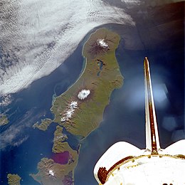
 Unimak Island from space, September 1992 (viewed from Shuttle Endeavour on STS-47) | |
 Unimak | |
| Geography | |
| Location | Northern Pacific Ocean |
| Coordinates | 54°46′06″N 164°11′12″W |
| Archipelago | Aleutian Islands |
| Area | 1,571.41 sq mi (4,069.9 km2) |
| Length | 95 km (59 mi) |
| Width | 116 km (72.1 mi) |
| Highest elevation | 9,373 ft (2856.9 m) |
| Highest point | Mount Shishaldin |
| Administration | |
United States | |
| State | Alaska |
| Borough | Aleutians East |
| Demographics | |
| Population | 64 (2000) |
| Pop. density | 0.02/km2 (0.05/sq mi) |

Geography
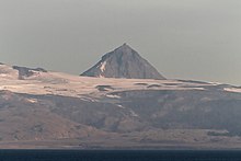
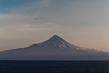
It is the easternmost island in the Aleutians and, with an area of 1,571.41 square miles (4,069.93 square kilometers), the ninth largest island in the United States and the 134th largest island in the world. It is home to Mount Shishaldin, one of the ten most active volcanoes in the world. According to the United States Census Bureau, there were 64 people living on Unimak as of the 2000 census, all of them in the city of False Pass at the eastern end of the island. Cape Lutke is a headland on the island. Cape Pankof is located at the extreme southwest of the island.
The Fisher Caldera is a volcanic crater in the west-central part of Unimak. Some characteristics include many volcanic cones and undrained lakes. It is named for Bernard Fisher, a U.S. Geological Survey geologist who was killed in Umnak Pass.
Mount Westdahl, 5,426 feet (1,654 m) in elevation, is a stratovolcano of the Aleutian Range on the island situated at its western end.
Natural history
When the Alaska National Interest Lands Conservation Act was passed on 2 December 1980, 910,000 acres (370,000 ha) of the island was designated as wilderness.[2] This area is managed by the United States Fish and Wildlife Service as part of the Alaska Maritime National Wildlife Refuge.
As a faunal extension of the Alaska Peninsula, Unimak has a relatively diverse assemblage of terrestrial mammals, including Alaska Peninsula brown bears and porcupine caribou. West of Unimak Island, the largest native mammal in the Aleutians is the red fox.
Buildings
Scotch Cap Lighthouse was built in 1903[3] and was staffed by the US Coast Guard. On April 1, 1946, during the 1946 Aleutian Islands earthquake, the lighthouse was struck by a tsunami. Even though the lighthouse was 98 feet (30 m) above the sea, the lighthouse slid into the sea, killing five Coast Guard personnel.[4]
The Cape Sarichef Lighthouse and the Cape Sarichef Airport are also located on the island.


See also
- Islands of Aleutians East Borough, Alaska
- Extreme points of the United States
References
- Bergsland, K. (1994). Aleut Dictionary. Fairbanks: Alaska Native Language Center.
- "Unimak Wilderness". Retrieved 2014-11-17.
- Prints of Poetry - A Gratitude Company (1946-04-01). "Ak - Scotch Cap Lighthouse". Titanic-nautical.com. Archived from the original on 2010-06-27. Retrieved 2017-12-16.
- DrGeorgePC website with photos
Further reading
- Titanic and Nautical Resource Center
- Unimak Island: Blocks 1046 through 1049 and 1055 through 1065, Census Tract 1, Aleutians East Borough, Alaska United States Census Bureau
External links
На других языках
[de] Unimak Island
Unimak Island ist die größte und östlichste Insel der Aleuten. Sie liegt nur durch die an der engsten Stelle weniger als 700 Meter breite Isanotski Strait vom Festland beim Kabuch Point getrennt, die die Ikatan Bay im Süden mit der Bechevin Bay im Norden verbindet. Nach Südosten bildet Unimak die Ikatan-Halbinsel aus, die nur über eine weniger als 500 Meter breite Landzunge mit der Insel verbunden ist. Der äußerste Punkt dieser Halbinsel heißt Kap Pankof.- [en] Unimak Island
[es] Isla Unimak
La isla Unimak (en inglés: Unimak Island; en aleutiano, Unimax[1]) es la isla más grande en la cadena de las islas Aleutianas del estado estadounidense de Alaska. Esta es la isla más oriental en las Aleutianas y, con un área de 1.571,41 mi² (4.069,9 kilómetros²), la novena isla más grande en los Estados Unidos y la 134.ª isla más grande en el mundo.[fr] Île Unimak
L'île Unimak, en anglais Unimak Island, en aléoute Unimax, est une île des États-Unis située dans les îles Aléoutiennes, en Alaska. C'est la plus vaste et la plus orientale de l'archipel.[it] Unimak
Unimak (in lingua aleutina Unimax[1]) è la più grande e la più orientale delle Aleutine e appartiene all'Alaska (USA). Fa parte del gruppo delle isole Fox e si trova nel mare di Bering. L'isola ha una superficie di 4.069,9 km². Vi sono vari vulcani sull'isola, il maggiore di questi è il Shishaldin (2.857 m), un vulcano attivo. Al censimento del 2000 vi erano 64 persone che vivevano su Unimak, tutte nella città di False Pass all'estremità orientale dell'isola.[ru] Унимак
У́нимак[1] (алеут. Unimax[2] , англ. Unimak Island) — остров, самый восточный из Алеутских островов, и самый большой из них, площадью 4069,9 км². Также является девятым по величине в США и 134-м в мире.Другой контент может иметь иную лицензию. Перед использованием материалов сайта WikiSort.org внимательно изучите правила лицензирования конкретных элементов наполнения сайта.
WikiSort.org - проект по пересортировке и дополнению контента Википедии