geo.wikisort.org - Island
Semisopochnoi Island or Unyak Island (obsolete Russian: Семисопочной, modern Russian: Семисопочный Semisopochny – "having seven hills"; Aleut: Unyax̂[1]) is part of the Rat Islands group in the western Aleutian Islands of Alaska. The island is uninhabited and provides an important nesting area for maritime birds. The island is of volcanic origin, containing several volcanoes including Mount Cerberus. It has a land area of 85.558 square miles (221.59 square km), measuring 11 miles (18 km) in length and 12 miles (20 km) in width.
 Eastern cone of Mount Cerberus in the Semisopochnoi Caldera. | |
 | |
 Semisopochnoi Location on a map of Alaska | |
| Geography | |
|---|---|
| Location | Bering Sea |
| Coordinates | 51°57′05″N 179°36′03″E |
| Archipelago | Rat Islands |
| Area | 221.59 km2 (85.56 sq mi) |
| Length | 18 km (11.2 mi) |
| Width | 20 km (12 mi) |
| Highest elevation | 1,221 m (4006 ft) |
| Administration | |
| State | |
At 179°46' East (+179.7667) (in the Eastern Hemisphere), the easternmost tip of Semisopochnoi is, by longitude, the easternmost land location in the United States and North America. Semisopochnoi sits only 14 minutes (0.2333 degrees) or 9.7 miles (15.6 km) west of the 180th meridian.
Wildlife
Semisopochnoi has no native land mammals. Arctic foxes were introduced to the island during the 19th century for fur farming and removed in 1997. Most ground-nesting bird species (Aleutian cackling goose, rock ptarmigan) and most burrow-nesting seabirds (storm-petrels, ancient murrelets, Cassin's auklets, tufted puffins) were extirpated by foxes; Semisopochnoi Island is currently in the early stages of recovery. The island has remained free of Norway rats.
The large least and crested auklet colony near Sugarloaf Head is one of the largest among the nine auklet colonies in the Aleutian Islands. Crested auklets and least auklets breed in one colony, located on the south facing slopes of Sugarloaf Peak volcano and its associated cinder cones near Sugarloaf Head. Semisopochnoi Island also supports a significant population of red-faced cormorants.
In total, Semisopochnoi supports well over a million seabirds, most of which are least auklets or crested auklets.[2]
Geology
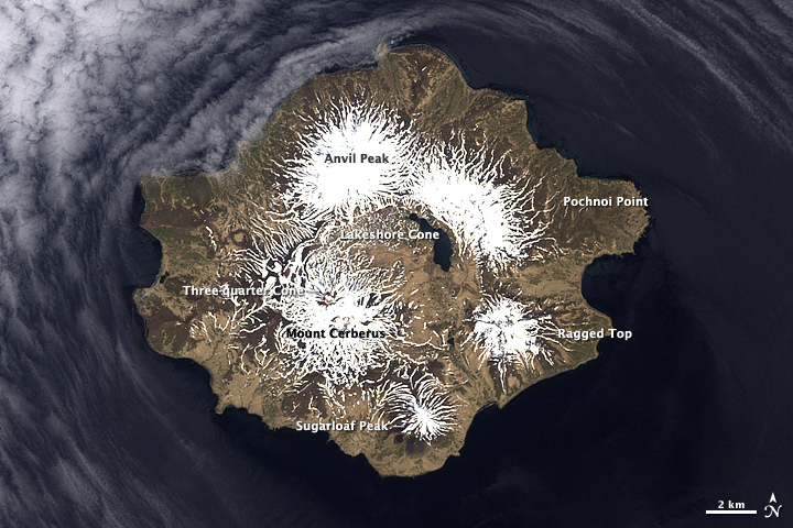
Semisopochnoi, the largest subaerial volcano of the western Aleutians, is 20 km wide at sea level and contains a caldera 8 km wide that formed as a result of collapse of a low-angle, dominantly basaltic volcano following the eruption of a large volume of dacitic pumice. The high point of the island is 1,221 meter Anvil Peak, a double-peaked cone that forms much of the island's northern part. The three-peaked, 774-meter high Mount Cerberus is a volcano within the caldera. Each of the peaks contains a summit crater; lava flows on the northern flank of Cerberus appear younger than those on the southern side. Other post-caldera volcanoes include the symmetrical 855 m high Sugarloaf Peak south-southeast of the caldera and Lakeshore Cone, a small cinder cone at the edge of Fenner Lake in the northeast part of the caldera. Most documented historical eruptions have originated from Cerberus, although Coats (1950) considered that both Sugarloaf and Lakeshore Cone within the caldera could have been active during historical time.[3][4][5]
Semisopochnoi's last known volcanic eruptions took place in October 2018 and July 2019.[6] A historic eruption of Semisopochnoi was reported in 1873, and at least four others may have occurred in the previous hundred years, but documentation is scant. These eruptions apparently emanated from the flanks of Mount Cerberus; the most recent flow appears to be less than a century old.[7]
Easternmost North America location debate

Semisopochnoi's position in the Aleutian Island Chain gives it the distinction of being the Aleutian island most immediately West of the 180th meridian, giving it longitudinal coordinates in the Eastern Hemisphere. Therefore, some have argued it is technically the easternmost location in North America. This is a counterintuitive argument considering its location near the extreme Western boundary of the United States, and depends on a series of assumptions about the definition of boundaries between hemispheres, boundaries between continents, as well as whether island locations should even be considered part of a continent.
The other contenders for the title of easternmost North America location are Nordost Rundingen, Greenland at 12°08' West (-12.1333) and Cape Spear, Newfoundland, Canada at 52°37' West (-52.6167) —which, along with Semisopochnoi, are all island locations. Cape St. Charles at 55° 37' West (-55.6167) on the Labrador Peninsula is the easternmost point of mainland North America. Cape Spear is the easternmost location relative to the geographic center of North America if Greenland is excluded because it is not politically part of North America. For this and other reasons, Cape Spear is traditionally considered to be the easternmost location in North America.
References
- Bergsland, K. (1994). Aleut Dictionary. Fairbanks: Alaska Native Language Center.
- Audubon Site Profile, Semisopochnoi Island
- "Semisopochnoi". Global Volcanism Program. Smithsonian Institution. Retrieved 2021-06-28.
- Coats R R, 1950. Volcanic activity in the Aleutian Arc. U S Geol Surv Bull, 974-B: 35-47
- Alaska Volcano Observatory, Semisopochnoi
- "Semisopochnoi - Historic eruptions".
- Wood, C. A., and Kienle, Juergen, (eds.), 1990, Volcanoes of North America: United States and Canada: New York, Cambridge University Press, 354 p.
External links
- Semisopochnoi Photos Photographs from Semisopochnoi Island, July 2008
- Google Earth view
| Authority control |
|---|
На других языках
[de] Semisopochnoi Island
Semisopochnoi Island (russisch Семисопочный (in Umschrift Semisopotschnoi); „Unyax“ oder „Hawadax“ auf Aleutisch; deutsch auch: Ratteninsel) ist eine den USA zugehörige Insel der westlichen Aleuten.- [en] Semisopochnoi Island
[es] Isla Semisopochnoi
La isla Semisopochnoi es una isla perteneciente al archipiélago de las islas Rata, en el grupo de las islas Aleutianas. La isla se encuentra deshabitada y provee de una importante área de nidificación de aves marinas. La isla es de origen volcánico, conteniendo diversos volcanes que incluyen el monte Cerberus. Semisopochnoi ocupa una superficie de 221,673 km².[fr] Semisopochnoi
Semisopochnoi est une île faisant partie des îles Rat dans les îles Aléoutiennes, en Alaska. C'est une île volcanique[1],[2]. Son point culminant est à 1 221 m.[it] Semisopochnoi
Semisopochnoi (in lingua aleutina Unyax[2]; in russo Семисопочный, Semisopočnyj) è un'isola che fa parte delle Rat, un gruppo delle Aleutine occidentali e appartiene all'Alaska (USA). Occupa la posizione più orientale del territorio negli Stati Uniti, è a soli 23 minuti a ovest del 180º meridiano e si trova quindi nell'emisfero orientale.[ru] Семисопочный
Семисопочный (англ. Semisopochnoi, алеут. Unyax̂, алеут. Уняҳ[1]) — остров в составе Крысьих островов, входящих в состав Алеутского архипелага на юге Берингова моря.Другой контент может иметь иную лицензию. Перед использованием материалов сайта WikiSort.org внимательно изучите правила лицензирования конкретных элементов наполнения сайта.
WikiSort.org - проект по пересортировке и дополнению контента Википедии