geo.wikisort.org - Island
The Diomede Islands (/ˌdaɪ.əˈmiːdiː/; Russian: острова́ Диоми́да, romanized: ostrová Diomída), also known in Russia as Gvozdev Islands (Russian: острова́ Гво́здева, romanized: ostrová Gvozdjeva), consist of two rocky, mesa-like islands:
- The Russian island of Big Diomede (part of Chukotka Autonomous Okrug), also known as Imaqłiq, Inaliq, Nunarbuk or Ratmanov Island
- The U.S. island of Little Diomede (part of Alaska) or Iŋaliq, also known as Krusenstern Island[lower-alpha 1]
| |
|---|---|
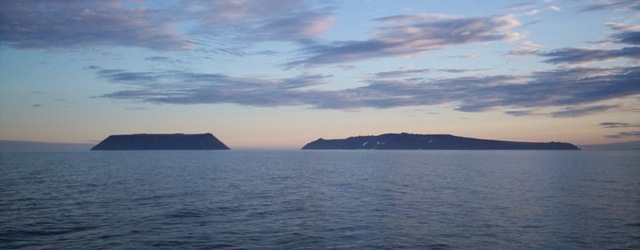 Diomede Islands: Little Diomede (left, U.S.) and Big Diomede (right, Russia) viewed from the north, looking south | |
 Satellite photo of the Bering Strait, with the Diomede Islands at center | |
| Geography | |
| Location | Bering Strait |
| Coordinates | 65°47′N 169°01′W |
| Total islands | 2 |
| Administration | |
Russia / United States | |
| Demographics | |
| Population |
|
| Additional information | |
| Time zones |
|
The Diomede Islands are located in the middle of the Bering Strait between mainland Alaska and Siberia. To the north is the Chukchi Sea and to the south is the Bering Sea. Fairway Rock, 9.3 km (5.8 mi) to the southeast, is also Alaskan, but generally not seen as part of the Diomede Islands. If marginal seas are considered, then they are the northernmost islands within the entire Pacific Ocean. Because they are separated by the International Date Line, Big Diomede is almost a day ahead of Little Diomede, but not completely; due to locally defined time zones, Big Diomede is only 21 hours ahead of Little Diomede (20 in summer).[1] Because of this, the islands are sometimes called Tomorrow Island (Big Diomede) and Yesterday Island (Little Diomede).
Etymology
The islands are named for the Greek Saint Diomedes; Danish navigator Vitus Bering sighted the Diomede Islands on August 16 (O.S., August 27 N.S.), 1728, the day on which the Russian Orthodox Church celebrates the memory of the saint.[2]
Location
The islands are separated by an international border, which also defines the International Date Line in that area, about 2 km (1.2 mi) from each island, at 168°58'37"W. At their closest points, the two islands are about 3.8 km (2.4 mi) apart.[3] The small habitation on Little Diomede Island is centered on the west side of the island at the village of Diomede.
Big Diomede Island is the easternmost point of Russia.
The Diomede Islands are often mentioned as likely intermediate stops for the hypothetical bridge or tunnel (Bering Strait crossing) spanning the Bering Strait.[4]
During winter, an ice bridge usually spans the distance between these two islands; therefore during such times it is theoretically possible (although not legal, since travel between the two islands is forbidden) to walk between the United States and Russia.
History

The first European to reach the Bering Strait was the Russian explorer Semyon Dezhnev in 1648. He reported two islands whose natives had bone lip ornaments, but it is not certain that these were the Diomedes. Danish navigator Vitus Bering re-discovered the Diomede Islands while leading a Russian expedition on 16 August (O.S., 26 August N.S.) 1728, the day when the Russian Orthodox Church celebrates the memory of the martyr St. Diomede (hence, the name of the islands). In 1732, a Russian geodesist, Mikhail Gvozdev, determined longitude and latitude for the two islands.[5]
The text of the 1867 treaty between the United States and Russia which finalized the Alaska Purchase uses the islands to designate the boundary between the two nations: the border separates "equidistantly Krusenstern Island, or Ignaluk, from Ratmanov Island, or Nunarbuk, and heads northward infinitely until it disappears completely in the Arctic Ocean."
During the Cold War, that gap constituted the border between the United States and the Soviet Union, and became known as the "Ice Curtain". In 1987, however, Lynne Cox swam from one island to the other, and was congratulated by both Mikhail Gorbachev and Ronald Reagan for her feat.[6]
In summer 1995, British television actor and documentary presenter Michael Palin started his counterclockwise circumnavigation of the Pacific Rim, encompassing 18 countries, on Little Diomede Island, as part of the BBC series Full Circle. He intended to set foot on it again at the end of his eight-month trek, but was unable to do so because of rough seas.
Big Diomede Island was traditionally the easternmost landmass before the International Date Line, and the first landmass to ring in a new year, if using local solar time. When using official time, however, a large area in eastern Russia and New Zealand also share the same time zone. New Zealand also has daylight saving time in effect during late December, but Russia does not (see time in New Zealand and time in Russia). This became moot in 1995, however, when the International Date Line was moved to the east of Kiribati and that country's easternmost time zone (GMT+14) is now the world's earliest.
After they established a military base there in 1948, the Soviet government relocated the indigenous population of Big Diomede Island to mainland Russia.[7] The island is now inhabited only by military units.[8] Little Diomede had an Inupiat population of 170,[9] which had declined to 115 at the 2010 census, entirely in the village site on the west side of the island, though the island as a whole comprises the city of Diomede. This village has a school, a post office and a store. Some residents are famous for their ivory carving. When weather permits, commercial air contact is maintained with the island as part of the US Essential Air Service.
See also
Notes
- Krusenstern Island may also refer to other places; see Krusenstern Island (disambiguation)
References
- "Two of the world's largest countries, Russia and the United States, at their closest points are separated by 2.4 miles, but are 21 hours apart! Find out how ... | ePaper | DAWN.COM". epaper.dawn.com. 18 November 2017. Retrieved 2018-06-21.
- Russia.com Archived 2008-09-20 at the Wayback Machine
- "Yesterday and Tomorrow Islands". earthobservatory.nasa.gov. 2018-01-27. Retrieved 2021-01-30.
- "Could a Russia–US rail tunnel be built?". BBC News. 21 October 2011.
- "Map of the New Discoveries in the Eastern Ocean". World Digital Library. 1781. Retrieved 10 February 2013.
- Smith, Martin. January 31, 1988. "The transcendent power of the solo athlete." Orange County Register, p. J1.
- "Profile: After 70 Years, A Diomede Family Reunion". KNOM Radio Mission. 2017-08-09. Retrieved 2022-06-06.
- Tuchman, Gary (30 September 2008). "You CAN see Russia from here!". Anderson Cooper 360°. CNN. Retrieved 12 June 2011.
- "Intent To Prepare a Draft Environmental Impact Statement for Navigation Improvements and Airport, Little Diomede Island, AK". U.S. Environmental Protection Agency. 29 October 2009. Archived from the original on 21 August 2009. Retrieved 12 June 2011.
External links
- Images of the islands (Archived May 9, 2008, at the Wayback Machine)
- Little Diomede page, with images
- Proposed Trans-Global Highway and AmerAsian Peace Tunnel
- Michael Palin site about Diomedes
|
Authority control | |
|---|---|
| General |
|
| National libraries | |
| Other | |
На других языках
[de] Diomedes-Inseln
Die Diomedes-Inseln (russisch Острова Диомида/Ostrowa Diomida, auch Gwosdew-Inseln genannt) sind eine Inselgruppe in der Beringstraße. Sie besteht aus der westlichen Ratmanow-Insel (oder Große Diomedes-Insel, Big Diomede, zu Russland gehörend) und der östlich gelegenen Kleinen Diomedes-Insel (Little Diomede, zu den USA gehörend). Zusätzlich zur amerikanisch-russischen Staatsgrenze verläuft zwischen den beiden Inseln auch die Internationale Datumsgrenze. Beide Inseln sind rund vier Kilometer voneinander entfernt. Gelegentlich zählt man den etwa 15 km südöstlich der Kleinen Diomedes-Insel gelegenen, unbewohnten Fairway-Felsen (USA) ebenfalls zur Inselgruppe.- [en] Diomede Islands
[es] Islas Diómedes
Las islas Diómedes, también conocidas como islas Gvózdev en Rusia, son dos islas rocosas de dimensiones reducidas. Se hallan en medio del estrecho de Bering, entre el mar de Chukchi y el mar de Bering. Estas islas se encuentran, a su vez, entre Alaska y la península de Chukotka.[2][fr] Îles Diomède
Les îles Diomède (en russe : Острова Диомида, Ostrova Diomida ; en anglais : Diomede Islands), également connues en Russie sous le nom d’îles Gvozdev, en inupiak Ignaluk, sont deux îles d’origine volcanique situées au milieu du détroit de Béring, entre la Sibérie et l’Alaska, près du cercle arctique. 3 km environ séparent les deux îles.[it] Isole Diomede
Le Isole Diomede (in russo: Oстрова́ Диомида?, traslitterato: Ostrova Diomida; in inglese Diomede Islands) sono due isole rocciose situate nel mezzo dello stretto di Bering. Il loro territorio è suddiviso tra Asia e America, più precisamente tra Russia e Stati Uniti d'America; curiosamente, sono anche soggette a due fusi orari completamente differenti.[ru] Острова Диомида
Острова́ Диоми́да, или Острова Гво́здева, — два острова и несколько скал в центре Берингова пролива, на расстоянии около 35 км от Чукотки и Аляски. Расстояние между островами составляет менее четырёх километров.Другой контент может иметь иную лицензию. Перед использованием материалов сайта WikiSort.org внимательно изучите правила лицензирования конкретных элементов наполнения сайта.
WikiSort.org - проект по пересортировке и дополнению контента Википедии