geo.wikisort.org - Island
Big Diomede Island (Russian: Остров Ратманова, romanized: ostrov Ratmanova; Ratmanov Island, Chukot: Имэлин; Inupiaq: Imaqłiq; or Tomorrow Island, due to the International Date Line) is the western island of the two Diomede Islands in the middle of the Bering Strait. The island is a part of the Chukotsky District of the Chukotka Autonomous Okrug of Russia. The border separating Russia and the United States runs north–south between the Diomede Islands.
| |
|---|---|
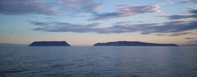
 Big Diomede seen from its nearest neighbor, Little Diomede | |
| Geography | |
| Location | Bering Strait |
| Coordinates | 65°46′52″N 169°03′25″W |
| Archipelago | Diomede Islands |
| Area | 29 km2 (11 sq mi) |
| Highest elevation | 477.3168 m (1566 ft) |
| Administration | |
| Demographics | |
| Population | 0 (permanent inhabitants) |
| Ethnic groups | Iñupiat (formerly) |
| Additional information | |
| Time zone |
|
Geography
Big Diomede Island is located about 45 km (28 mi) southeast of Cape Dezhnev on the Chukchi Peninsula and is Russia's easternmost point according to the International Date Line (if measuring by longtitude, it is the Westernmost point of Russia). The coordinates are 65°46′52″N 169°03′25″W. The rocky tuya-type island has an area of about 29 km2 (11 sq mi)[1] The International Date Line is about 1.3 km (0.81 mi)[2] east of the island. The highest point of the island is at 65°46'24.64" N, 169°04'06.61" W where the elevation reaches 1,566 feet (477 m).
There is a small settlement on the north coast at 65°48′50″N 169°02′5″W. There is a helipad at 65°48′36″N 169°01′46″W.
History
The island was originally inhabited by Iñupiat. The First Alaskans Institute says: "The people of the Diomede and King Islands are Inupiat [...]".[3]
The first European to reach the islands was the Russian explorer Semyon Dezhnyov in 1648. Vitus Bering landed on the Diomede Islands on August 16, 1728, the day on which the Russian Orthodox Church celebrates the memory of the martyr St. Diomede.[4]
In 1732, the Russian geodesist Mikhail Gvozdev plotted the island's map.
In 1867, during the Alaska Purchase, the new border between the nations was drawn between the Big Diomede and Little Diomede islands.
20th century
During World War II, Big Diomede became a military base, and remained so for some time into the Cold War.[5]
After World War II, the native population was forced off Big Diomede Island to the mainland in order to avoid contacts across the border. Today, unlike Alaska's neighboring Little Diomede Island, it has no permanent native population, but it is the site of a Russian weather station and a base of Border Service of the Federal Security Service of the Russian Federation troops (FSB).[6][7]
During the Cold War, the section of the border between the U.S. and the USSR separating Big and Little Diomede became known as the "Ice Curtain". On 7 August 1987, however, Lynne Cox, an American long-distance swimmer, swam from Little Diomede to Big Diomede (approximately 3.5 km or 2.2 mi) in ice-cold waters. She was congratulated jointly by Mikhail Gorbachev and Ronald Reagan four months later at the signing of the INF Missile Treaty at the White House, when Gorbachev made a toast. He and President Reagan lifted their glasses and Gorbachev said: "Last summer it took one brave American by the name of Lynne Cox just two hours to swim from one of our countries to the other. We saw on television how sincere and friendly the meeting was between our people and the Americans when she stepped onto the Soviet shore. She proved by her courage how close to each other our peoples live".[8]
Lisunov Li-2 crash
There is no airstrip on the island, but being flat on the top, some landings were carried out in order to deliver supplies. On 13 June 1971 a Lisunov Li-2 belonging to the Soviet Border Troops crashed in the centre of the island. All crew members were injured and the green hull remains at 65.7783°N 169.0666°W.
Fauna
Eleven species of birds including such as puffins and guillemots[9] have been found on Big Diomede. In 1976 a rufous hummingbird was identified on the island.[10] This finding, unique so far in Russia, was very likely due to a dispersed specimen. For mammals, pinnipeds (e.g. ringed and bearded seals, walruses[11]) and cetaceans (e.g. gray and rarer bowhead whales) inhabit the waters around the island.[12]
See also
References
- "Diomede Islands". Funk & Wagnalls New Encyclopedia. World Almanac Education Group. 2006. Archived from the original on 2009-03-26.
- Wikimapia
- Bering Straits, First Alaskans Institute, Regional Fact Sheets
- Russia.com Archived 2008-09-20 at the Wayback Machine
- "Diomede – Inalik, Alaska". Usgennet.org. Archived from the original on 2012-04-24. Retrieved 2012-03-24.
- Diomede Islands, britannica.com
- "Google Maps". Maps.google.com. 1970-01-01. Retrieved 2012-03-24.
- Cox, Lynne. "Swimming to Antarctica,Tales of a Long-Distance Swimmer", Knopf, 2004, p. 275.
- 2016. Bird Watching in the Russian Arctic
- Newfield, Nancy L.; Nielsen, Barbara (1996). Hummingbird Gardens: Attracting Nature's Jewels to Your Backyard. Houghton Mifflin Harcourt. pp. 53–. ISBN 1-881527-87-5.
- Hughes P.. 2016. Arctic thrill: an expedition through the Northwest Passage. How to spend it - Financial Times. Retrieved on March 01, 2017
- Jarvenpa R.. Brumbach J. H.. 2006. Circumpolar Lives and Livelihood: A Comparative Ethnoarchaeology of Gender and Subsistence. pp.239. University of Nebraska Press. Retrieved on March 01, 2017
|
На других языках
[de] Ratmanow-Insel
Die Ratmanow-Insel (russisch Остров Ратманова / Ostrow Ratmanowa, Inupiaq Imaqliq[1]), auch Große Diomedes-Insel (englisch Big Diomede Island) genannt, bildet mit der etwa 4 km östlich liegenden Little Diomede Island und dem unbewohnten Fairway Rock (beide gehören zum US-Bundesstaat Alaska) die Gruppe der Diomedes-Inseln. Sie ist der östlichste Punkt Russlands. Das russische Festland im Westen ist 35,68 Kilometer entfernt.- [en] Big Diomede
[it] Grande Diomede
La Grande Diomede (in russo: остров Ратманова?, traslitterato: ostrov Ratmanova; in inglese: Big Diomede e nel suo nome nativo Imaqliq) è una delle due isole rocciose situate al centro dello Stretto di Bering, fra l'Alaska e l'estremo oriente della Russia, l'altra è la Piccola Diomede. Amministrativamente l'isola appartiene al Circondario autonomo di Čukotka.[ru] Остров Ратманова
Остров Ратма́нова (чук. Имэлин, инуитск. Imaqliq — «окружённый водой») — остров в составе островов Диомида в Беринговом проливе, самая восточная точка территории России.Другой контент может иметь иную лицензию. Перед использованием материалов сайта WikiSort.org внимательно изучите правила лицензирования конкретных элементов наполнения сайта.
WikiSort.org - проект по пересортировке и дополнению контента Википедии