geo.wikisort.org - Island
King Island (Inupiaq: Ugiuvak; Russian: Остров Кинг) (King's Island in early US sources) is an island in the Bering Sea, west of Alaska. It is about 40 miles (64 km) west of Cape Douglas and is south of Wales, Alaska.

Geography

King island is a small island located about 40 miles (64 km) offshore, south of the village of Wales, Alaska and about 90 miles northwest of Nome. The island is about 1 mile (1.6 km) wide with steep slopes on all sides. It was named by James Cook, first European to sight the island in 1778, for Lt. James King, a member of his party. It is part of the Bering Sea unit of the Alaska Maritime National Wildlife Refuge.
Population
The island was once the winter home of a group of about 413 Inupiat who called themselves Asiuluk, meaning "people of the sea," or Ugiuvaŋmiut, from Ugiuvak, the village of King Island and "miut," meaning "people of" or "group of people".
The Ugiuvaŋmiut spent their summers engaging in subsistence hunting and gathering on King Island and on the mainland near the location of present-day Nome, Alaska. Their winters were spent in other subsistence activities, particularly hunting and fishing on the ice. Subsistence activities on and around the island included hunting seals and walruses, crab fishing, and gathering bird eggs and other foods. The spring and summer was the important time of gathering to the Ukivokmiut, while the winters were the time of dance. Due to the limited daylight during the winter, the days were spent dancing in the "Qagri", or men's communal house. As an example, the month of December is known to the Uġiuvaŋmiut as Sauyatugvik or "the time of drumming".
After the establishment of Nome, the islanders began to sell intricate carvings to residents of Nome during the summer.
Population relocation
In the mid-1900s the Bureau of Indian Affairs closed the school on Uġiuvak, forcefully taking the children of Ukivok to go to school on mainland Alaska, leaving the elders and adults to gather the needed food for winter. Because the children were not on the island to help gather food, the adults and elders had no choice but to move to mainland Alaska to make their living. By 1970, all King Island people had moved to mainland Alaska year-round.
Although the King Islanders have moved off the island, they have kept a very distinct cultural identity, living a very similar life as they had on the island. Some King Islanders still return to the island to gather subsistence foods, such as walrus and seal.
In 2005 and 2006 the National Science Foundation (NSF) funded a research project which brought a few King Island natives back to the island. Some participants had not been back to the island in 50 years.[needs update]
Demographics
| Historical population | |||
|---|---|---|---|
| Census | Pop. | %± | |
| 1880 | 100 | — | |
| 1890 | 200 | 100.0% | |
| 1910 | 119 | — | |
| 1920 | 137 | 15.1% | |
| 1930 | 170 | 24.1% | |
| 1940 | 208 | 22.4% | |
| 1960 | 66 | — | |
| 1980 | 0 | — | |
| 1990 | 0 | — | |
| U.S. Decennial Census[1] | |||
King Island first appeared on the 1880 U.S. Census as the unincorporated native eskimo village of "Ookivagamute."[2] In 1890, it returned as Uġiuvak. It next appeared in 1910 as King Island and would continue to report until 1960, with the exception of 1950 when no figure was reported. It next reported as Uġiuvak again, classified as a native village (ANVSA) in 1980 and 1990, but with no residents. It has not reported since.
Gallery
 King Island
 King Island: Rock formations that resemble ruins, on the saddle of the island
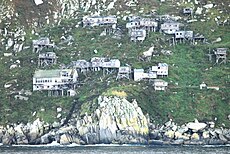 Ugiuvak, abandoned Inupiat stilt village, in 2010
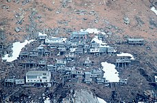 Abandoned stilt village Ugiuvak, photographed 1978. The large white building near the bottom of the slope is the former Bureau of Indian Affairs school.
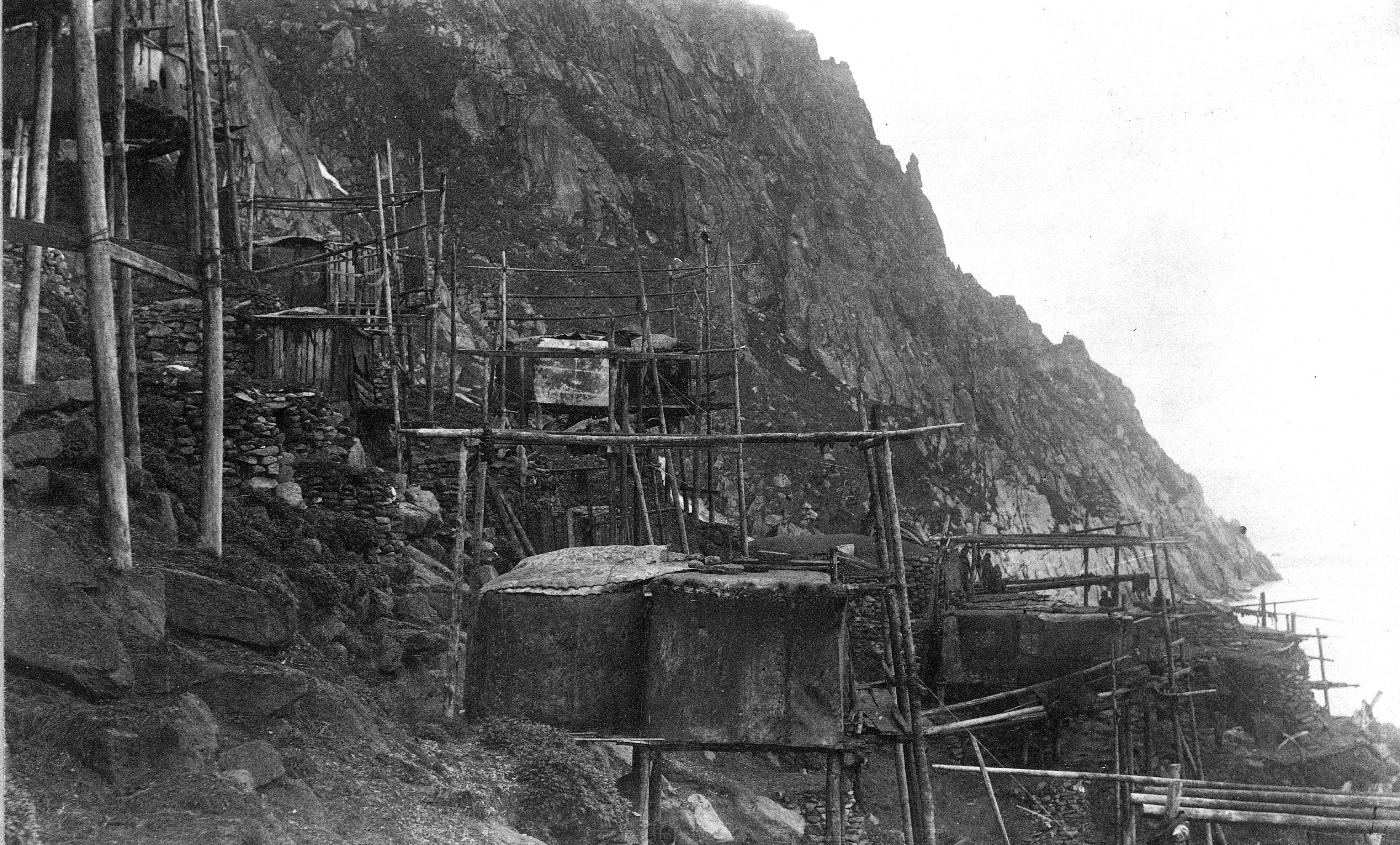
 Ugiuvak about 1892. Walrus-hide summer houses and stone winter houses are visible.
 King Island residents in kayaks, about 1892. The kayaks are of the characteristic King Island style. Several carry more than one person or items on deck, and the paddlers are using single-blade paddles. Two-blade paddles were also used.


See also
- King Island Native Community
Explanatory notes
- "U.S. Decennial Census". Census.gov. Archived from the original on May 7, 2015. Retrieved June 6, 2013.
- "Geological Survey Professional Paper". U.S. Government Printing Office. 12 August 2018. Retrieved 12 August 2018 – via Google Books.
External links
- Ancient mask returned to Alaska ghost village, MSNBC, January 18, 2008
- Photogallery of traditional ecological knowledge (TEK) of King Island, Alaska[dead link] , Oregon State University, October 28, 2008
- Munoz photographs - King Island early 1950s
- Survey of a King Island kayak
- Deanna M Kingston, "King Island", Encyclopedia of the Arctic, A-F p 1090, Routledge, 2012.
- Curtis, Edward P The North American Indian. Volume 20 - The Alaskan Eskimo. p 99-103
- https://web.archive.org/web/20130512233632/http://www.kawerak.org/tribalHomePages/kingIsland/
- http://www.alaskadispatch.com/article/king-island-living-community-and-mystical-place Archived 2013-07-31 at the Wayback Machine
Municipalities and communities of Nome Census Area, Alaska, United States | ||
|---|---|---|
| Cities |  | |
| CDP | ||
| Unincorporated communities | ||
| Ghost towns |
| |
| ||
На других языках
[de] King Island (Alaska)
King Island (Inupiaq: Ugiuvak) ist eine Insel im Beringmeer westlich der Seward-Halbinsel von Alaska. Die Insel befindet sich etwa 64 km westlich von Cape Douglas. Sie besteht primär aus einem gut 200 m hohen und 2,5 km langen Fels.- [en] King Island (Alaska)
[es] Isla del Rey (Alaska)
La Isla del Rey (en inglés: King Island) es una isla localizada en el mar de Bering, al oeste de Alaska, Estados Unidos.[1][fr] King Island (Alaska)
King Island est une île inhabitée située dans la mer de Bering, à l'ouest de l'Alaska. Elle se trouve à 64 km du cap Douglas, et est au sud de Wales. L'île fut découverte par le capitaine James Cook en 1778 qui la nomma ainsi en l'honneur du lieutenant James King, un officier de son expédition.[it] Isola King (Alaska)
King (in lingua inupiatun[1] Ugiuvak) è un'isola del mare di Bering ad ovest dell'Alaska. Si trova 64 km ad ovest di Cape Douglas e a sud di Wales, la cittadina più occidentale del continente nordamericano. L'isola appartiene all'Alaska (USA) e fa parte dell'Alaska Maritime National Wildlife Refuge.[ru] Кинг (остров, Аляска)
Остров Кинг (англ. King Island, инуитск. Ugiuvak) — остров в Беринговом море, к западу от побережья Аляски в 64 км от мыса Дуглас, южнее мыса Принца Уэльского.Другой контент может иметь иную лицензию. Перед использованием материалов сайта WikiSort.org внимательно изучите правила лицензирования конкретных элементов наполнения сайта.
WikiSort.org - проект по пересортировке и дополнению контента Википедии