geo.wikisort.org - Island
St. Matthew Island (Russian: Остров Святого Матвея) is an uninhabited, remote island in the Bering Sea in Alaska, 183 miles (295 km) west-northwest of Nunivak Island. The entire island's natural scenery and wildlife is protected as it is part of the Bering Sea unit of the Alaska Maritime National Wildlife Refuge.
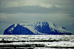 View of Cape Upright, St. Matthew Island | |
 | |
| Geography | |
|---|---|
| Location | Bering Sea |
| Coordinates | 60°24′31″N 172°43′12″W |
| Archipelago | none |
| Area | 137.857 sq mi (357.05 km2) |
| Length | 31.7 mi (51 km) |
| Highest elevation | 1,476 ft (449.9 m) |
| Administration | |
United States | |
| State | Alaska |
| Demographics | |
| Population | Uninhabited |


The island has a land area of 137.857 sq mi (357.05 km2), making it the 43rd largest island in the United States. Its most southerly point is Cape Upright which features cliff faces which exceed 1,000 feet (300 m). Similar heights are found at Glory of Russia Cape on the north, and the highest point, 1,476 feet (450 m) above sea level, lies south from the island center.
There is a small island off its northwestern point called Hall Island. The 3.1 miles (5.0 km) wide sound between the two islands is called Sarichef Strait. A small rocky islet called Pinnacle Rock lies 9.3 miles (15.0 km) to the south of Saint Matthew Island.
The United States Coast Guard maintained a staffed LORAN station on the island during the 1940s.
Geology and climate
The climatic conditions in the entire Bering Sea Area, according to National Climatic Data Center (1986), is reported as maritime with "considerable wind and cool, humid and cloudy conditions" with mean annual temperature of 37.8 °F (3.2 °C) and annual precipitation of 15.3 in (390 mm) on St. Matthew Island. The geological formation recorded on St. Matthew Island consists of calc-alkaline volcanic rocks of Late Cretaceous and earliest tertiary age with Pergelic Cryaquolls and Pergelic Cryoborolls soil types.[1]
Human habitation
The first recorded attempt at settlement occurred in 1809, when a Russian group led by Demid Ilyich Kulikalov, under the guise of the Russian-American Company, established an experimental outpost.[2]
A 2013 sailing expedition to the island showed that, in spite of the lack of human habitation, extensive areas of beach were heavily contaminated with plastic marine debris, particularly from the fishing industry.[3]
Mammals
Presently, Arctic foxes and insular voles[4] are the only mammals resident on the island, though polar bears occasionally visit via pack ice. Notably, St. Matthew Island represents the southern limit of the range of polar bears in the Bering Sea.[5]
![Reindeer introduced to St. Matthew Island in 1944 increased from 29 animals at that time to 6,000 in the summer of 1963, a drastic overshoot of the island’s carrying capacity causing a crash die-off the following winter to 42 animals. Based on the size of the island, recent estimates put the carrying capacity at about 1,670 animals [Klein, D. R. (n.d.). The Introduction, Increase, and Crash of Reindeer on St. Matthew Island. Retrieved May 25, 2016, from https://web.archive.org/web/20110709032911/http://dieoff.org/page80.htm].](http://upload.wikimedia.org/wikipedia/commons/thumb/7/7a/St._Matthew_Island_Reindeer_Population.svg/220px-St._Matthew_Island_Reindeer_Population.svg.png)
In 1944, 29 reindeer were introduced to the island by the United States Coast Guard to provide an emergency food source. The Coast Guard abandoned the island a few years later, leaving the reindeer. Subsequently, the reindeer population rose to about 6,000 by 1963[6] and then died off in the next two years to 42 animals.[7] A scientific study attributed the population crash to the limited food supply in interaction with climatic factors (the winter of 1963–64 was exceptionally severe in the region). By the 1980s, the reindeer population had completely died out. Environmentalists see this as an issue of overpopulation. For example, ecologist Garrett Hardin cited the "natural experiment" of St. Matthew Island of the reindeer population explosion and collapse as a paradigmatic example of the consequences of overpopulation in his essay An Ecolate View of the Human Predicament.[8]
Fish
There are two major lakes on the island, North Lake and Big Lake. The lakes contain a greater number of fish species (at least 5) than other nearby islands.[9]
Lichen
Lichen studies were conducted on the island in the 1990s to prepare a list of lichens with their habitat, composition and distribution pattern. These studies were considered important for characterizing the eating habits of caribou and air quality. The vegetation of the islands has been classified as wet, moist and alpine tundra, based on landforms and drainage patterns. The plant communities were attributed to five categories. In the area of rock rubble fields and high ridges the vegetation was mainly crustacean lichens. Among the 148 lichen species of the islands, 125 showed the Arctic–alpine geographic distribution, 74 boreal, 18 were coastal, 9 amphi-Berengian and 41 widespread, with many species falling into more than one category. The lichen diversity was characterized by wide-ranging Arctic–alpine and boreal species; it was evaluated as luxuriant that was linked to reindeer species disappearing from the area.[1]
Further reading
- The Island That Humans Can't Conquer via Hakai magazine
References
- Stephen S. Talbot, sandra Looman Talbot, John W. Thomson and Wilfred B. Schofield (2001). "Lichens from St. Mathew and St. Paul Islands, Bearing Sea Alaska" (PDF). Bryologist. 104 (1): 47–58. doi:10.1639/0007-2745(2001)104[0047:LFSMAS]2.0.CO;2. JSTOR 3244914.
{{cite journal}}: CS1 maint: multiple names: authors list (link) - Black, Lydia T. Russians in Alaska: 1732–1867. University of Alaska Press, 2004. pp. 213
- Bray, Chris. "Teleport Update #16". Archived from the original on 2021-12-13. Retrieved 13 February 2015.
- Smithsonian: ''Microtus abbreviatus'' (2008). Mnh.si.edu. Retrieved on 2011-06-25.
- C. Michael Hogan (2008) Polar Bear: Ursus maritimus, Globaltwitcher.com, ed. N. Stromberg Archived 2008-12-24 at the Wayback Machine
- Alaska Science Forum (2003)''When Reindeer Paradise Turned to Purgatory'' Archived 2012-05-03 at the Wayback Machine. Gi.alaska.edu (2003-11-13). Retrieved on 2011-06-25.
- David R. Klein, ''The Introduction, Increase, and Crash of Reindeer on St. Matthew Island'', Alaska Cooperative Wildlife Research Unit, University of Alaska Archived 2011-07-09 at the Wayback Machine. Dieoff.org. Retrieved on 2011-06-25.
- Hardin, Garrett (1985). "An Ecolate View of the Human Predicament". The Garrett Hardin Society. Retrieved 2011-02-09.
- Marc Romano; David Klein; Anthony DeGange; Steve Delehanty; Monte Garroutte; Dennis Griffin; Richard Kleinleder; Derek Sikes; heather Renner (December 2013). "REPORT OF 2012 EXPEDTION TO ST. MATTHEW AND OTHER BERING SEA ISLANDS" (PDF). U.S. Fish and Wildlife Service. p. 9. Archived from the original (PDF) on 22 March 2016. Retrieved 29 July 2014.
- St. Matthew Island: Block 1045, Census Tract 1, Bethel Census Area, Alaska United States Census Bureau
Authority control | |
|---|---|
| General |
|
| National libraries | |
На других языках
[de] St.-Matthew-Insel
Die St.-Matthew-Insel (englisch St. Matthew Island) ist eine zum US-Bundesstaat Alaska gehörende, unbewohnte Insel in der Beringsee. Sie liegt in der Bethel Census Area.- [en] St. Matthew Island
[es] Isla de San Mateo
La isla de San Mateo es una remota isla en el mar de Bering, en Alaska,[1] a 295,0 km al ONO de la isla Nunivak. La isla tiene una superficie de 357,05 km², por lo que es la 43.ª isla más grande de los Estados Unidos. Su punto más al sur es el cabo Vertical que cuenta con acantilados que superan los 300 m. El punto más alto de la isla está a 450 msnm.[fr] Île Saint-Matthieu
L'île Saint-Matthieu est une île inhabitée située dans la mer de Béring, à 295 km à l'ouest de l'île Nunivak. Elle fait partie de l'Alaska.[it] Isola San Matteo
L'isola di St. Matthew, o isola di San Matteo è una remota isola degli Stati Uniti d'America situata nel mare di Bering. Amministrativamente è parte dello Stato federato dell'Alaska. Si trova 295 km a ovest di Nunivak.[ru] Остров Святого Матвея
Остров Святого Матвея (англ. St. Matthew Island) — остров в южной части Берингова пролива. В административном отношении является частью штата Аляска, США. Открыт экспедицией лейтенанта И. Б. Синдта[1][2][комм. 1]. Остров не заселён. С 1980 года остров является частью Аляскинского морского национального заповедника.Другой контент может иметь иную лицензию. Перед использованием материалов сайта WikiSort.org внимательно изучите правила лицензирования конкретных элементов наполнения сайта.
WikiSort.org - проект по пересортировке и дополнению контента Википедии