geo.wikisort.org - Island
Fairway Rock (Inupiaq: Ugiiyaq) (Census block 1047, Nome, Alaska) is a small islet with mostly vertical rock faces in the Bering Strait, located southeast of the Diomede Islands and west of Alaska's Cape Prince of Wales. Part of Alaska, a U.S. state, the islet has an area of 0.3 km2 (0.12 mi2). Known to Inuit of the Bering Strait region in prehistory, Fairway was documented by James Cook in 1778 and named by Frederick Beechey in 1826. Although uninhabited, the island is a nesting site for seabirds — most notably the least and crested auklet — which prompt egg-collecting visits from local indigenous peoples. The United States Navy placed radioisotope thermoelectric generator-powered environmental monitoring equipment on the island from the 1960s through the 1990s.
Geography
The granite mass that is now Fairway Rock, like the larger nearby Diomede Islands, is the remnant of an earlier era of glaciation.[1]
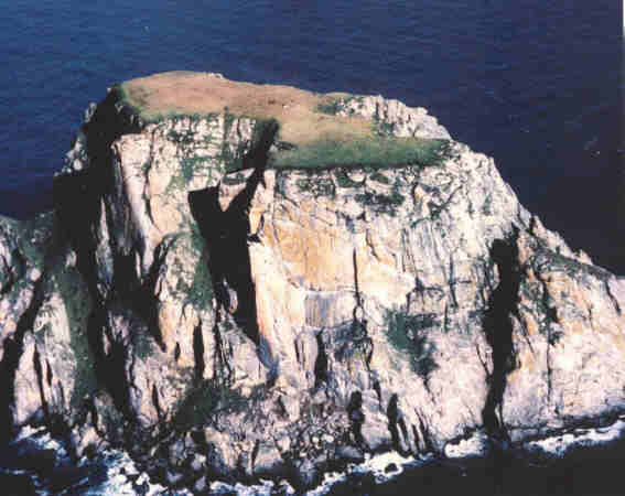
Fairway Rock is situated 12 mi (19 km) SSE of Little Diomede Island and 20 mi (32 km) W of Cape Prince of Wales, at 65°37′N 168°44′W.[2] The island is variously reported as from 300 m (984 ft)[3] to 1.5 km (0.93 mi) in length.[2] Rising steeply from the surrounding waters to 534 ft (163 m) above sea level, Fairway Rock can be easily seen from the mainland coast of Alaska at Cape Prince of Wales.[4] Because of its steep cliffs, it poses no additional maritime hazard.[5] The Bering Strait around Fairway Rock is relatively shallow — about 50 m (164 ft) in depth — and oceanographic transects show the island to lie near a current velocity minimum for the strait.[6] Ocean currents north of Fairway Rock are occasionally studied as an example of a real-world system where a Von Kármán vortex street is generated.[7]
Fairway Rock lies inside Alaska's Nome Census Area and Alaska Department of Fish and Game Wildlife Conservation Unit 22E.[8] It is conveyed to Inalik Native Corporation. Fairway Rock appears on United States Geological Survey topographic maps in the Teller Quadrangle.[9]
Flora and fauna
The island's bold cliffs are a haven for many migratory birds. The indigenous peoples who have lived nearby for thousands of years come to the island to gather bird eggs in the spring.[10][11][12] and have continued to do so as recently as the 1990s.[13]

The island supports a breeding colony of about 35,000 seabirds, including some 25,000 least auklets and crested auklets.[3] In 1925, the tufted puffin (Fratercula cirrhata), horned puffin (Fratercula corniculata), parakeet auklets (Aethia psittacula), and Pallas' murre (Uria lomvia arra) were reported at Fairway Rock, nesting in the crevices of the island's cliffs.[14] A 1960 account reports that Eskimo inhabitants of Little Diomede reported a glaucous gull (Larus hyperboreus) colony on Fairway Rock larger than that on Little Diomede.[15]
The Steller sea lion may also breed on Fairway Rock.[16]
History
Discovery and establishment of outpost
For the sake of convenience, I named each of these islands. The eastern one I called Fairway Rock, as it is an excellent guide to the eastern channel, which is the widest and best.
— Capt. Frederick William Beechey, Narrative of a voyage to the Pacific and Beering's Strait to cooperate with the polar expeditions: performed in His Majesty's ship Blossom, pp. 337–338.
Fairway Rock was sighted by Captain James Cook on August 8, 1778.[17] It was named by the English naval officer and geographer Frederick William Beechey upon sighting the island in July 1826. Unlike the names he gave to the Diomede Islands, the name "Fairway" has persisted.[18]
Fairway Rock was passed and mentioned within the accounts of John Muir's voyage aboard the Corwin in 1881[19] and Roald Amundsen aboard the Gjøa in 1906.[20]
What is considered the last offensive action of the American Civil War happened in this area: the CSS Shenandoah fell upon a fleet of whalers working the waters near Alaska's Little Diomede Island and sank more than two dozen ships on June 22, 1865. This is chronicled in the book The Last Shot.[21]
In 1964, the U.S. Coast Guard icebreaker USCGC Northwind (WAGB-282) visited the rock, and installed an unmanned, propane-powered oceanographic station in order to measure water flows across the Bering Strait. Northwinds crew continued to help maintain the station until its closure.[22]
The radioisotope thermoelectric generator

On August 11, 1966,[23] the US Navy placed a strontium-powered radioisotope thermoelectric generator (RTG) atop Fairway Rock for "powering environmental instruments".[24][25] At this time Commander John C. LeDoux was in charge of NavFac's shore based nuclear power program, whose over 200 trained men only had one power plant to run. With a new NavFac Chief taking over soon, Commander LeDoux feared the program might be cancelled if it had no other applications. In his memoir LeDoux writes that, "like good marketers we produced a catalog of what was available and sent it to all Navy commands."[26] Within two weeks they received an urgent request for a generator at Fairway Rock.
Fairway Rock's then-current generator was propane-fueled and could not operate in the winter months. Since the generator powered "detectors on the ocean floor for submarine traffic heading North"[26] it was considered essential that it be replaced rapidly. However, moving the new generator from Baltimore to Alaska to Fairway Rock would be a complicated process and LeDoux suspected that "red tape" would delay the operation for a long time.
LeDoux was able to use contacts in the AEC to get approval to move the generator in only four days, which he considered "a miracle in itself."[26] A weekly Air Force flight to Vietnam was able to take it to Alaska. Getting the generator onto the island itself proved more difficult, since there were no Navy helicopters in the area. A bush pilot was contracted, two refueling locations were set up by the Army Corps of Engineers, and a Coast Guard escort (USCGC Northwind (WAGB-282)) was assigned, allowing the journey over the Bering Strait to be made safely.[26] In the end, the project only took 10 days and "was done with no money or paperwork – mostly phone calls and personal visits." LeDoux was impressed that a project involving so many disparate military and non-military parties could be carried off in such a short span of time.[26]
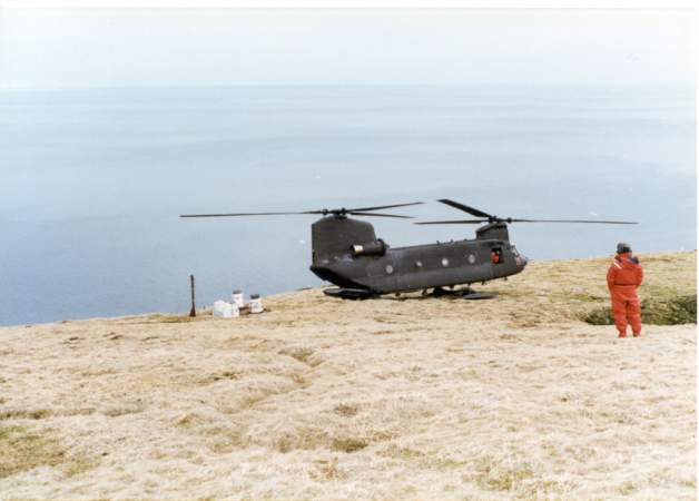
The device, developed by Martin Marietta, was the first commercially developed instrument of its kind deployed for unattended field use by the U.S. government. This use was cited in 1978 congressional hearings on potential uses for nuclear waste.[23] In 1981 two additional RTGs were added. All three RTGs were removed from the rock in 1995[24] in a joint Army/Navy operation with Chinook helicopters from B Company, 4th Battalion, 123rd Aviation Regiment, the "Sugar Bears"[27] of Fort Wainwright, AK.[28] The three RTGs were transported from Fort Wainwright, AK to the Richland Consolidation Facility at Hanford Nuclear Reservation in Washington state for disposal.[24][29][30][31]
See also
- Rockall, a similar, even smaller rock island in the northern Atlantic Ocean
References
- John Muir (1917). "XVII. Meeting the Point Barrow Expedition". In William Frederic Badè (ed.). The Cruise of the Corwin. Sierraclub.org.
- "Fairway Rock". The Columbia Gazetteer of North America. Columbia University Press. 2000. Archived from the original on 2007-11-20. Retrieved 2006-08-05.
- "Little Diomede Island & Fairway Rock". The Important Bird Areas Historical Results. National Audibon Society. 2004. Archived from the original on March 12, 2007. Retrieved 2006-08-05.
- "Cape Prince of Wales". Retrieved 2006-08-06.
- Sailing Directions (Enroute) – East Coast of Russia (PDF). National Geospatial-Intelligence Agency. 2004.
- Coachmann, Lawrence K. (1976). Bering Strait. University of Washington Press. p. 76. ISBN 0-295-95442-6.
- Andrei Yu Ivanov; Anna I. Ginzburg (September 2002). "Oceanic eddies in synthetic aperture radar images" (PDF). Proc. Indian Acad. Sci. 111 (3): 281–296. Bibcode:2002InEPS.111..281I. doi:10.1007/BF02701974. ISSN 0253-4126. Retrieved 2006-08-06.
- Alaska 2006–2007 Hunting Regulations (PDF). Division of Wildlife Conservation, Alaska Department of Fish and Game. 2006. pp. 92–93.
- "TopoZone – USGS Map Detail – Teller Quadrangle". Retrieved 2006-09-30.
- "Neeluk" (PDF). Gacpc.com. Archived from the original (PDF) on 2007-10-05. Retrieved 2013-04-01.
- "Icewindow". Icewindow. Retrieved 2013-04-01.
- "Cenaliulriit Coastal Resource Service Area" (PDF). Retrieved 2013-04-01.
- Robert Jarvenpa; Hetty Jo Brumbach (2006). Circumpolar Lives And Livelihood: A Comparative Ethnoarchaeology of Gender And Subsistence. U of Nebraska Press. pp. 250–. ISBN 978-0-8032-2606-7.
- Alfred M. Bailey (1925). "A Report on the Birds of Northwestern Alaska and Regions Adjacent to Bering Strait. Part Ii". The Condor. 27 (2): 62–67. doi:10.2307/1363055. JSTOR 1363055.
- Karl W. Kenyon; James W. Brooks (1960). "Birds of Little Diomede Island, Alaska". The Condor. 62 (6): 457–463. doi:10.2307/1365592. JSTOR 1365592.
- "ESI data" (PDF). Retrieved 2013-04-01.
- "The Third Voyage (1776–1780)". Captain Cook Society. 2013-02-16. Retrieved 2013-04-01.
- Beechey, Frederick William (1831). Narrative of a voyage to the Pacific and Beering's Strait, to co- operate with the polar expeditions: performed in His Majesty's ship Blossom, under the command of Captain F.W. Beechey, R.N., F.R.S. &c. in the years 1825, 26, 27, 28. London: H. Colburn and R. Bentley. pp. 337–338. ISBN 0-665-47594-2.
- Muir, John (1917). The Cruise of the Corwin. Boston: Houghton Mifflin. ISBN 0-618-05701-3.
- "Le passage de Nord Ouest". Retrieved 2006-09-30.
- Schooler, Lynn (2005). The Last Shot: The Incredible Story of the C.S.S. Shenandoah and the True Conclusion of the American Civil War. New York: Ecco. ISBN 0-06-052333-6. Retrieved 2005-07-19.
{{cite book}}: CS1 maint: url-status (link) - Welcome Aboard USCGC Northwind. Pamphlet. 1968. U.S.C.G, Thirteenth District, Seattle, WA. Retrieved: 15 April 2014.
- United States. Congress. Senate. Committee on Commerce, Science, and Transportation. Subcommittee on Science, Technology, and Space (1978). Nuclear Waste Disposal: Hearings Before the Subcommittees on Science, Technology, and Space and Surface Transportation of the Committee on Commerce, Science, and Transportation, United States Senate, Ninety-fifth Congress, Second Session ... U.S. Government Printing Office.
{{cite book}}: CS1 maint: multiple names: authors list (link) - "Arctic Submarine Lab History". Csp.navy.mil. Archived from the original on 2013-02-18. Retrieved 2013-04-01.
- "Nuclear By-Products : A Resource for the Future". Heritage.org. Archived from the original on 2009-10-19. Retrieved 2013-04-01.
- LeDoux, John (2003). LeDoux Vie: The Sweet Life of John C. LeDoux. Trafford Publishing. ISBN 1-4120-0079-3.
- B Company,"Sugar Bears", 4th BN, 123rd AVN REGT History, 1995. Chinook Helicopter.com. http://ww.chinook-helicopter.com/history/units/242nd_ASHC/Unit_History/B-4_123rd_Aviation_Regiment_Sugar_Bears_History_1995.pdf
- GlobalSecurity.com 4th Battalion (Theater), 123rd Aviation Regiment http://www.globalsecurity.org/military/agency/army/4-123avn.htm
- US Ecology. https://www.usecology.com/Home.aspx Archived 2015-05-20 at the Wayback Machine Retrieved: 18 May 2015.
- Department of Ecology, State of Washington. Nuclear Waste. Commercial Low-Level Radioactive Waste Disposal. http://www.ecy.wa.gov/programs/nwp/llrw/llrw.htm Archived 2017-12-13 at the Wayback Machine Retrieved: 18 May 2015.
- U.S. NuclearRegulatory Commission. Locations of Low-Level Waste Disposal Facilities http://www.nrc.gov/waste/llw-disposal/licensing/locations.html Retrieved: 18 May 2015.
External links
- US Navy Arctic Submarine Laboratory:
- Summer 1986 Photo
- Spring 1989 Photo
- Full text of Hazardous and toxic waste disposal : joint hearings before the Subcommittees on Environmental Pollution and Resource Protection of the Committee on Environment and Public Works, United States Senate, Ninety-sixth Congress, first session https://archive.org/stream/hazardoustoxicwa01unit/hazardoustoxicwa01unit_djvu.txt
На других языках
[de] Fairway Rock
Der Fairway Rock ist ein 308.541 m² (0,31 km²) großes Eiland in der Beringstraße 19 km südöstlich der Diomedes-Inseln und 28,5 km westlich des Kap Prince of Wales von Alaska. Als erster Europäer dokumentierte James Cook am 8. August 1778 den Felsen,[1] der im Juli 1826 von Frederick Beechey, einem englischen Marineoffizier und Geographen, seinen heutigen Namen bekam.[2]- [en] Fairway Rock
[fr] Fairway Rock
Fairway Rock est une petite île américaine dans le détroit de Béring, située au sud-est des îles Diomède et à l'ouest du cap Prince-de-Galles en Alaska (65° 37′ N, 168° 44′ O).Другой контент может иметь иную лицензию. Перед использованием материалов сайта WikiSort.org внимательно изучите правила лицензирования конкретных элементов наполнения сайта.
WikiSort.org - проект по пересортировке и дополнению контента Википедии