geo.wikisort.org - Insel
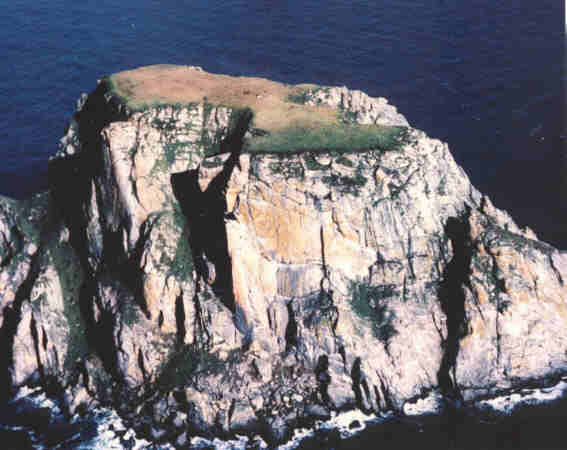
Der Fairway Rock ist ein 308.541 m² (0,31 km²) großes Eiland in der Beringstraße 19 km südöstlich der Diomedes-Inseln und 28,5 km westlich des Kap Prince of Wales von Alaska. Als erster Europäer dokumentierte James Cook am 8. August 1778 den Felsen,[1] der im Juli 1826 von Frederick Beechey, einem englischen Marineoffizier und Geographen, seinen heutigen Namen bekam.[2]
| Fairway Rock | ||
|---|---|---|
 | ||
| Gewässer | Beringstraße | |
| Inselgruppe | Diomedes-Inseln | |
| Geographische Lage | 65° 37′ 26″ N, 168° 44′ 23″ W | |
| ||
| Länge | 700 m | |
| Breite | 620 m | |
| Fläche | 31 ha | |
| Höchste Erhebung | 163 m | |
| Einwohner | unbewohnt | |
 | ||

Der Granitfelsen wurde, wie die beiden Diomedes-Inseln, durch glaziale Erosion aus den umgebenden weniger widerständigen Gesteinen herausgearbeitet.[3] Das Alter des im Granit befindlichen Biotit wurde mittels der Kalium-Argon-Methode auf etwa 110 Mio. Jahre bestimmt.[4] Der Felsen ragt steil aus dem Wasser auf und kann von der Küste Alaskas aus gesehen werden. Die umgebende Wassertiefe beträgt etwa 50 m.
Politisch gehört das Eiland zu Alaska und ist dort dem Nome Census Area und der Einheit 22E der Alaska Department of Fish and Game’s Wildlife Conservation zugeordnet. Es gehört zur Beringmeer-Einheit des Alaska Maritime National Wildlife Refuge.
Das Eiland ist unbewohnt, wird jedoch von Meeresvögeln wie dem Zwergalk oder dem Schopfalk als Nistgebiet genutzt. Ureinwohner Alaskas kamen seit prähistorischen Zeiten zu dem Felsen, um Eier zu sammeln.
Von 1966 bis 1995 hatte die United States Navy eine von einem Radioisotopengenerator betriebene Umweltüberwachungseinrichtung auf der Insel stationiert.
Weblinks
Fairway Rock im Geographic Names Information System des United States Geological Survey (englisch).
Einzelnachweise
- Captain James Cook: The Third Voyage (1776–1780). Captain Cook Society, abgerufen am 14. Mai 2017 (englisch).
- Frederick William Beechey: Narrative of a voyage to the Pacific and Beering’s strait, to co-operate with the polar expeditions: performed in His Majesty’s ship Blossom, under the command of Captain F. W. Beechey, R. N., F.R.S. &c. in the years 1825, 26, 27, 28. Band 1. Henry Colburn and Richard Bentley, London 1831, S. 337 f. (englisch, online).
- John Muir: The Cruise of the Corwin. Journal of the Arctic Expedition of 1881 in search of De Long and the Jeannette. Houghton Mifflin Company, Boston / New York 1917, Appendix I: The Glaciation of the Arctic and Subarctic Regions Visited during the Cruise, S. 248 (englisch, online [PDF; 5,0 MB]).
- Alison B. Till, Julie A. Dumoulin, Melanie B. Werdon, Heather A. Bleick: Preliminary bedrock geologic map of the Seward Peninsula, Alaska, and accompanying conodont data. Open-File Report 2009-1254. United States Geological Survey (USGS), 29. September 2010, S. 13, Kgu: Granitic rocks, undifferentiated (Cretaceous) (englisch, online [PDF; 3,9 MB]).
На других языках
- [de] Fairway Rock
[en] Fairway Rock
Fairway Rock (Inupiaq: Ugiiyaq) (Census block 1047, Nome, Alaska) is a small islet with mostly vertical rock faces in the Bering Strait, located southeast of the Diomede Islands and west of Alaska's Cape Prince of Wales. Part of Alaska, a U.S. state, the islet has an area of 0.3 km2 (0.12 mi2). Known to Inuit of the Bering Strait region in prehistory, Fairway was documented by James Cook in 1778 and named by Frederick Beechey in 1826. Although uninhabited, the island is a nesting site for seabirds — most notably the least and crested auklet — which prompt egg-collecting visits from local indigenous peoples. The United States Navy placed radioisotope thermoelectric generator-powered environmental monitoring equipment on the island from the 1960s through the 1990s.[fr] Fairway Rock
Fairway Rock est une petite île américaine dans le détroit de Béring, située au sud-est des îles Diomède et à l'ouest du cap Prince-de-Galles en Alaska (65° 37′ N, 168° 44′ O).Другой контент может иметь иную лицензию. Перед использованием материалов сайта WikiSort.org внимательно изучите правила лицензирования конкретных элементов наполнения сайта.
WikiSort.org - проект по пересортировке и дополнению контента Википедии