geo.wikisort.org - Mountains
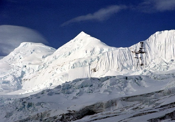
Mount Bona is one of the major mountains of the Saint Elias Mountains in eastern Alaska, and is the fifth-highest independent peak in the United States.[4] It is either the tenth- or eleventh-highest peak in North America. Mount Bona and its adjacent neighbor Mount Churchill are both large ice-covered stratovolcanoes. Bona has the distinction of being the highest volcano in the United States and the fourth-highest in North America, outranked only by the three highest Mexican volcanoes, Pico de Orizaba, Popocatépetl, and Iztaccíhuatl. Its summit is a small stratovolcano on top of a high platform of sedimentary rocks.[5]
| Mount Bona | |
|---|---|
 | |
| Highest point | |
| Elevation | 16,550 ft (5,040 m)[1] NAVD88 |
| Prominence | 6,900 ft (2,100 m)[1] |
| Isolation | 49.7 mi (80.0 km)[1] |
| Listing |
|
| Coordinates | 61°23′08″N 141°44′55″W[2] |
| Geography | |
 Mount Bona Location in Alaska | |
| Location | Wrangell–St. Elias National Park and Preserve, Alaska, U.S. |
| Parent range | Saint Elias Mountains |
| Topo map | USGS McCarthy B-2 |
| Geology | |
| Mountain type | Stratovolcano |
| Last eruption | 847 AD |
| Climbing | |
| First ascent | July 2, 1930 by Allen Carpé, Terris Moore, Andrew Taylor |
| Easiest route | Glacier climb (Alaska Grade 2)[3] |
The mountain's massif is covered almost entirely by icefields and glaciers, and it is the principal source of ice for the Klutlan Glacier, which flows east for over 40 miles (64 km) into the Yukon Territory of Canada. The mountain also contributes a large volume of ice to the north-flowing Russell Glacier system.
Mount Bona was named by Prince Luigi Amedeo, Duke of the Abruzzi in 1897, who saw the peak while making the first ascent of Mount Saint Elias about 80 miles (130 km) to the southeast. He named it after the Bona, his racing yacht.[2] The mountain was first climbed in 1930 by Allen Carpé, Terris Moore, and Andrew Taylor, from the Russell Glacier on the west of the peak. The current standard route is the East Ridge; a climb of nearby Mount Churchill is a relatively easy addition via this route as well.[3]

Elevation
Mount Bona's exact elevation is uncertain. USGS 1:250,000 topographical maps show an elevation of 16,421 feet (5,005 m),[6] which was determined in 1913 by International Boundary Commission surveyors.[7] However, USGS 1:63,360 topographical maps do not show a spot height, and their contour lines indicate a summit elevation of 16,550±50 feet (5045±15 meters).[8] Many sources quote the latter figure.[9]
See also
- List of mountain peaks of North America
- List of the highest major summits of the United States
- List of the most prominent summits of the United States
- List of the most isolated major summits of the United States
- List of volcanoes in the United States
References and notes
- "Mount Bona, Alaska". Peakbagger.com. Retrieved December 30, 2015.
- "Mount Bona". Geographic Names Information System. United States Geological Survey. Retrieved 2007-03-10.
- Wood, Michael; Coombs, Colby (2001). Alaska: A Climbing Guide. Mountaineers Books. pp. 161–162. ISBN 0-89886-724-X.
- This counts both the North and South Peaks of Denali (Mount McKinley), which is not a universally accepted practice. See Fourteener.
- "Mount Bona". Alaska Volcano Observatory. U.S. Geological Survey. Retrieved 17 February 2019.
- 1:250,000 Sheet "Mc Carthy, Alaska", US Geological Survey, 1960
- International Boundary Commission (1918). Joint Report Upon the Survey and Demarcation of the International Boundary Between the United States and Canada Along the 141st Meridian from the Arctic Ocean to Mount St. Elias. p. 158.
- 1:63,360 Sheet "Mc Carthy (B-2), Alaska", US Geological Survey, 1959
- "Mount Bona". bivouac.com. Retrieved 2021-11-11.
{{cite web}}: CS1 maint: url-status (link)
- Richter, Donald H.; Rosenkrans, Danny S.; Steigerwald, Margaret J. (1995). Guide to the Volcanoes of the Western Wrangell Mountains, Alaska (PDF). USGS Bulletin 2072. Retrieved 2017-08-06.
- Richter, Donald H.; Preller, Cindi C.; Labay, Keith A.; Shew, Nora B. (2006). Geologic Map of the Wrangell-Saint Elias National Park and Preserve, Alaska. USGS Scientific Investigations Map 2877.
- Winkler, Gary R. (2000). A Geologic Guide to Wrangell—Saint Elias National Park and Preserve, Alaska: A Tectonic Collage of Northbound Terranes. USGS Professional Paper 1616. ISBN 0-607-92676-7.
- Wood, Charles A.; Kienle, Jürgen, eds. (1990). Volcanoes of North America. Cambridge University Press. ISBN 0-521-43811-X.
External links
 Definitions from Wiktionary
 Media from Commons
 News from Wikinews
 Quotations from Wikiquote
 Texts from Wikisource
 Textbooks from Wikibooks
 Resources from Wikiversity
- Mount Bona at the Alaska Volcano Observatory
- "Mount Bona (Alaska)". Bivouac.com. Retrieved 2009-01-06.
- "Churchill". Global Volcanism Program. Smithsonian Institution. Retrieved 2009-01-06.
Juneau (capital) | ||
| Topics |
|  |
| Society |
| |
| Regions |
| |
| Largest cities pop. over 25,000 | ||
| Smaller cities pop. over 2,000 | ||
| Boroughs | ||
| Native Corporations |
| |
| Census Areas |
| |
На других языках
[de] Mount Bona
Der Mount Bona ist ein Schichtvulkan in der Eliaskette im Osten Alaskas. Mit einer Höhe von 5005 m ist er der fünfthöchste Berg der Vereinigten Staaten. Nach den drei höchsten mexikanischen Gipfeln, Pico de Orizaba, Popocatépetl und Iztaccíhuatl, ist Mount Bona der höchste Vulkan Nordamerikas.- [en] Mount Bona
[fr] Mont Bona
Le mont Bona est un volcan de la chaîne Saint-Élie situé en Alaska, aux États-Unis[2].[it] Monte Bona
Il monte Bona è una delle principali vette della catena montuosa dei Monti Sant'Elia, localizzato nelle regioni orientali dell'Alaska. Situato vicino al monte Churchill, ed entrambi sono degli stratovulcani, il Bona si distingue come il più alto vulcano degli Stati Uniti e il quarto più elevato del Nord America, dopo i tre vulcani messicani, Pico de Orizaba, Popocatépetl e Iztaccíhuatl. Il massiccio è quasi interamente coperto da ghiacciai, e la sua vetta tocca i 5.005 metri sul livello del mare.[ru] Бона (гора)
Бона (англ. Bona) — горная вершина, расположена неподалёку от границы Аляски и Территории Юкон.Другой контент может иметь иную лицензию. Перед использованием материалов сайта WikiSort.org внимательно изучите правила лицензирования конкретных элементов наполнения сайта.
WikiSort.org - проект по пересортировке и дополнению контента Википедии