geo.wikisort.org - Mountains
Popocatépetl (Spanish pronunciation: [popokaˈtepetl] (![]() listen); Nahuatl: Popōcatepētl Nahuatl pronunciation: [popoːkaˈtepeːt͡ɬ]) is an active stratovolcano located in the states of Puebla, Morelos, and Mexico in central Mexico. It lies in the eastern half of the Trans-Mexican volcanic belt. At 5,426 m (17,802 ft)[1] it is the second highest peak in Mexico, after Citlaltépetl (Pico de Orizaba) at 5,636 m (18,491 ft).
listen); Nahuatl: Popōcatepētl Nahuatl pronunciation: [popoːkaˈtepeːt͡ɬ]) is an active stratovolcano located in the states of Puebla, Morelos, and Mexico in central Mexico. It lies in the eastern half of the Trans-Mexican volcanic belt. At 5,426 m (17,802 ft)[1] it is the second highest peak in Mexico, after Citlaltépetl (Pico de Orizaba) at 5,636 m (18,491 ft).
| Popocatépetl | |
|---|---|
 Popocatépetl, viewed from the north from Paso de Cortés. | |
| Highest point | |
| Elevation | 5,426 m (17,802 ft)[lower-alpha 1] |
| Prominence | 3,020 m (9,910 ft)[2][3] |
| Isolation | 143 km (89 mi) |
| Listing |
|
| Coordinates | 19°01′20″N 98°37′40″W |
| Geography | |
 Popocatépetl Location in Mexico  Popocatépetl Popocatépetl (Mexico)  Popocatépetl Popocatépetl (North America) | |
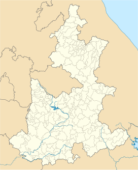
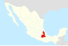
| Location | Mexico-Puebla-Morelos, Mexico |
| Geology | |
| Mountain type | Stratovolcano |
| Last eruption | 2004 to 2022 (ongoing)[4] |
| Climbing | |
| Easiest route | rock/snow climb |
It is linked to the twin volcano of Iztaccihuatl to the north by the high saddle known as the "Paso de Cortés".[5] Izta-Popo Zoquiapan National Park, wherein the two volcanoes are located, is named after them.[6][7]
Popocatépetl is 70 km (43 mi) southeast of Mexico City, from where it can be seen regularly, depending on atmospheric conditions. Until recently, the volcano was one of three tall peaks in Mexico to contain glaciers,[8] the others being Iztaccihuatl and Pico de Orizaba. In the 1990s, the glaciers such as Glaciar Norte (North Glacier) greatly decreased in size, partly due to warmer temperatures but largely due to increased volcanic activity.[9] By early 2001, Popocatépetl's glaciers were gone; ice remained on the volcano, but no longer displayed the characteristic features of glaciers such as crevasses.[10][11][12]
Lava erupting from Popocatépetl has historically been predominantly andesitic, but it has also erupted large volumes of dacite.[13] Magma produced in the current cycle of activity tends to be a mixture of the two with the andesites being rich in magnesium.[14]
In literature and art
In the poem Romance ("Chimborazo, Cotopaxi....Popocatapetl") by Walter J. Turner (1916), Cotopaxi is one of the romantic locations that has stolen the poet's heart.[15]
Popocatépetl and Iztaccíhuatl feature prominently in Malcolm Lowry’s 1947 novel Under the Volcano as well as the novel’s 1984 US drama film adaptation directed by John Huston.
The legend of the two volcanos feature as the central story in Duncan Tonatiuh’s children's book The Princess and the Warrior: A Tale of Two Volcanoes.
In visual arts, Popocatépetl is the subject of Marsden Hartley’s 1932 painting Popocatepetl, Spirited Morning--Mexico, now at the Smithsonian American Art Museum in Washington, D.C.
Several works by Dr. Atl feature Popocatépetl, among them his 1928 Self-Portrait with Popocatépetl, now in the Philadelphia Museum of Art and his 1942 The Shadow of Popo, now in the Museo Nacional de Arte in Mexico City.
Popocatépetl also features prominently in the Juan Manuel Martinez Caltenco mural on the upper floor Municipal Palace of Atlixco, Puebla. The murals cover much of the palace’s interior and represent an important Poblano contribution to the Mexican muralism movement.
Jesús Helguera’s 1940 masterpiece La Leyenda de los Volcanes in Chicago’s National Museum of Mexican Art depicts the myth of Popocatépetl and Iztaccíhuatl.
The 1966 Warner Brothers cartoon Snow Excuse is set above the snow line on Popocatépetl.
The band Pop-a-Cat-a-Petal (later Ultrasound) were named after a mondegreen of Popocatépetl.
Name

The name Popocatépetl comes from the Nahuatl words popōca (Nahuatl pronunciation: [poˈpoːka]) "it smokes" and tepētl [ˈtepeːt͡ɬ] "mountain", meaning Smoking Mountain. The volcano is also referred to by Mexicans as El Popo affectionately, or to shorten the full name . The alternate nickname Don Goyo comes from the mountain's association in the lore of the region with San Gregorio, "Goyo" being a nickname-like short form of Gregorio. The name was extended by those who lived in Santiago Xalitzina, a small community that resided 12 km from the volcano. Legend says that many years ago, a villager met an old man on the slopes of the mountain, who introduced himself as Gregorio Chino Popocatépetl. Gregorio was a personification of the spirit of the volcano, and communicates with the locals to warn them if an eruption is about to happen. Thus, every March 12, the day of San Gregorio, the locals bring flowers and food to the volcano to celebrate the saint.[16][17][18]
Geology
The stratovolcano contains a steep-walled, 400 m × 600 m (1,300 ft × 2,000 ft) wide crater. The generally symmetrical volcano is modified by the sharp-peaked Ventorrillo on the NW, a remnant of an earlier volcano. At least three previous major cones were destroyed by gravitational failure during the Pleistocene, producing massive debris avalanche deposits covering broad areas south of the volcano. The modern volcano was constructed to the south of the late-Pleistocene to Holocene El Fraile cone.[1] Three major Plinian eruptions, the most recent of which took place about 800 AD, have occurred from Popocatépetl since the mid-Holocene, accompanied by pyroclastic flows and voluminous lahars that swept basins below the volcano.[1]
According to paleomagnetic studies, the volcano is about 730,000 years old. It is cone shaped with a diameter of 25 km (16 mi) at its base, with a peak elevation of 5,450 m (17,880 ft). The crater is elliptical with an orientation northeast-southwest. The walls of the crater vary from 600 to 840 m (1,970 to 2,760 ft) in height. Popocatépetl is currently active after being dormant for about half of last century. Its activity increased in 1991 and smoke has been seen constantly emanating from the crater since 1993. The volcano is monitored by the Deep Earth Carbon Degassing Project.[citation needed]
History
The geological history of Popocatépetl began with the formation of the ancestral volcano Nexpayantla. About 200,000 years ago, Nexpayantla collapsed in an eruption, leaving a caldera, in which the next volcano, known as El Fraile, began to form. Another eruption about 50,000 years ago caused that to collapse, and Popocatépetl rose from that. Around 23,000 years ago, a lateral eruption (believed to be larger than the 1980 eruption of Mount St. Helens) destroyed the volcano's ancient cone and created an avalanche that reached up to 70 kilometres (43 mi) from the summit. The debris field from that is one of four around the volcano, and it is also the youngest.[19]
Three Plinian eruptions are known to have taken place: 3,000 years ago (3195–2830 BC), 2,150 years ago (800–215 BC), and 1,100 years ago (likely 823 AD).[19] The latter two buried the nearby village of Tetimpa, preserving evidence of preclassical culture.[20]
The first recorded European ascent of the volcano was made by an expedition led by Diego de Ordaz in 1519.[21]: 182 The early-16th-century monasteries on the slopes of the mountain are a World Heritage Site.
Eruptions


Popocatépetl is one of the most active volcanoes in Mexico and the most famous,[22] having had more than 15 major eruptions since the arrival of the Spanish in 1519.
- Timeline
- Mid-to late first century: A violent VEI-6 eruption may have caused the large migrations that settled Teotihuacan, according to DNA analysis of teeth and bones.[23]
- Eruptions were observed in 1363, 1509, 1512, 1519–1528, 1530, 1539, 1540, 1548, 1562–1570, 1571, 1592, 1642, 1663, 1664, 1665, 1697, 1720, 1802, 1919, 1923, 1925, and 1933.[1]
- 1947: A major eruption.[citation needed]
- 21 December 1994: The volcano spewed gas and ash, which was carried as far as 25 km (16 mi) away by prevailing winds. The activity prompted the evacuation of nearby towns and scientists to begin monitoring for an eruption.[17]
- December 2000: Tens of thousands of people were evacuated by the government, based on the warnings of scientists. The volcano then made its largest display in 1,200 years.[11][12][24][25]
- 25 December 2005: The volcano's crater produced an explosion which ejected a large column of smoke and ash about 3 km (9,800 ft) into the atmosphere and expulsion of lava.[citation needed]
- January and February 2012: Scientists observed increased volcanic activity at Popocatépetl. On January 25, 2012, an ash explosion occurred on the mountain, causing much dust and ash to contaminate the atmosphere around it.[17]
- 15 April 2012: Reports of superheated rock fragments being hurled into the air by the volcano. Ash and water vapor plumes were reported 15 times over 24 hours.[26]
- Wednesday 8 May 2013, at 7:28 p.m. local time: Popocatépetl erupted again with a high amplitude tremor that lasted and was recorded for 3.5 hours. It began with plumes of ash that rose 3 km (9,800 ft) into the air and began drifting west at first, but later began to drift east-southeast, covering areas of the villages of San Juan Tianguismanalco, San Pedro Benito Juárez and the City of Puebla in smoke and ash. Explosions from the volcano itself subsequently ejected fragments of fiery volcanic rock to distances of 700 m (2,300 ft) from the crater.[27][28]
- July 4, 2013: Due to several eruptions of steam and ash for at least 24 hours, at least six U.S. airlines canceled more than 40 flights into and out of Mexico City International Airport and Toluca International Airport that day.[29]
- 27 August–September 2014: CENAPRED reported explosions, accompanied by steam-and-gas emissions with minor ash and ash plumes that rose 800-3,000 m above Popocatépetl's crater and drifted west, southwest, and west-southwest. On most nights incandescence was observed, increasing during times with larger emissions.[30]
- 1 September 2014: Partial visibility due to cloud cover.[31]
- 29 and 31 August 2014: The Washington Volcanic Ash Advisory Center (VAAC) reported discrete ash emissions.[1]
- 7 January 2015: CENAPRED reported that ash from recent explosions coats the snow on the volcano's upper slopes.[32]
- 28 March 2016: An ash column 2,000 m (6,600 ft) high was released, prompting the establishment of a 12-kilometre (7.5 mi) "security ring" around the summit.[33]
- 3 April 2016: Popocatépetl erupted, spewing lava, ash and rock.[34]
- August 2016: Eruptions continued, with four discrete blasts on August 17.[35]
- 10 November 2017 at 7:25 local time, eruption continued.[1]
- 15 December 2018 at 18:57 local time, spewing lava, ash and rock.[36]
- 22 January 2019 21:06 local time, spewing ash up 3 km (9,800 ft) high and incandescent fragments 2 km away.[37]
- 19 March 2019 21:38 local time, fragments of the dome shot within 1.6–2.4-kilometre (1–1+1⁄2 mi) radius.[38] Due to continuing activity, on March 28 2019, based on the analysis of the available information, the Scientific Advisory Committee of the Popocatépetl volcano recommended changing the phase of the Yellow Volcanic Warning Light Phase 2 to Yellow Phase 3, which is a preventive measure against the observed changes.[39]
- June 3, 2019 Popocatépetl continued its explosive uptick by firing an ash column to approximately 11 km (37,000 ft) a.s.l.[40]
- June 18, 2019 Popocatépetl continued to erupt, spewing ash clouds to 8.5 km (28,000 ft).[41]
- June 24, 2019 Popocatépetl erupted once more, sending a massive ash cloud some kilometres (thousands of feet) into the air.[42]
- July 18, 2019 Popocatépetl erupts three times, sending ashes 1.5 km (4,900 ft) into the air each time.[43]
- July 20, 2019, volcanic ash is reported in Xochimilco after the morning's eruption.[44]
- October 2019, the volcano erupted multiple times in one night.[45]
- November 2019, an eruption partially forced a KLM flight from Amsterdam to Mexico City to turn back.[46]
- January 9, 2020 Popocatépetl expelled lava and rock and sent ash clouds to 6.1 km (20,000 ft).[47]
- January 27. 2020 Popocatépetl erupted in a sensational nighttime display of rock and ash.[48][49]
- February 5, 2020 Popocatépetl had a moderate explosion producing an ash plume that went up 1.5 km. Had more explosions on February 15, 18, and 22 having ash plumes rising that ranged from 400- 1,200 m.[50]
Gallery
 Fumaroles on Popocatépetl
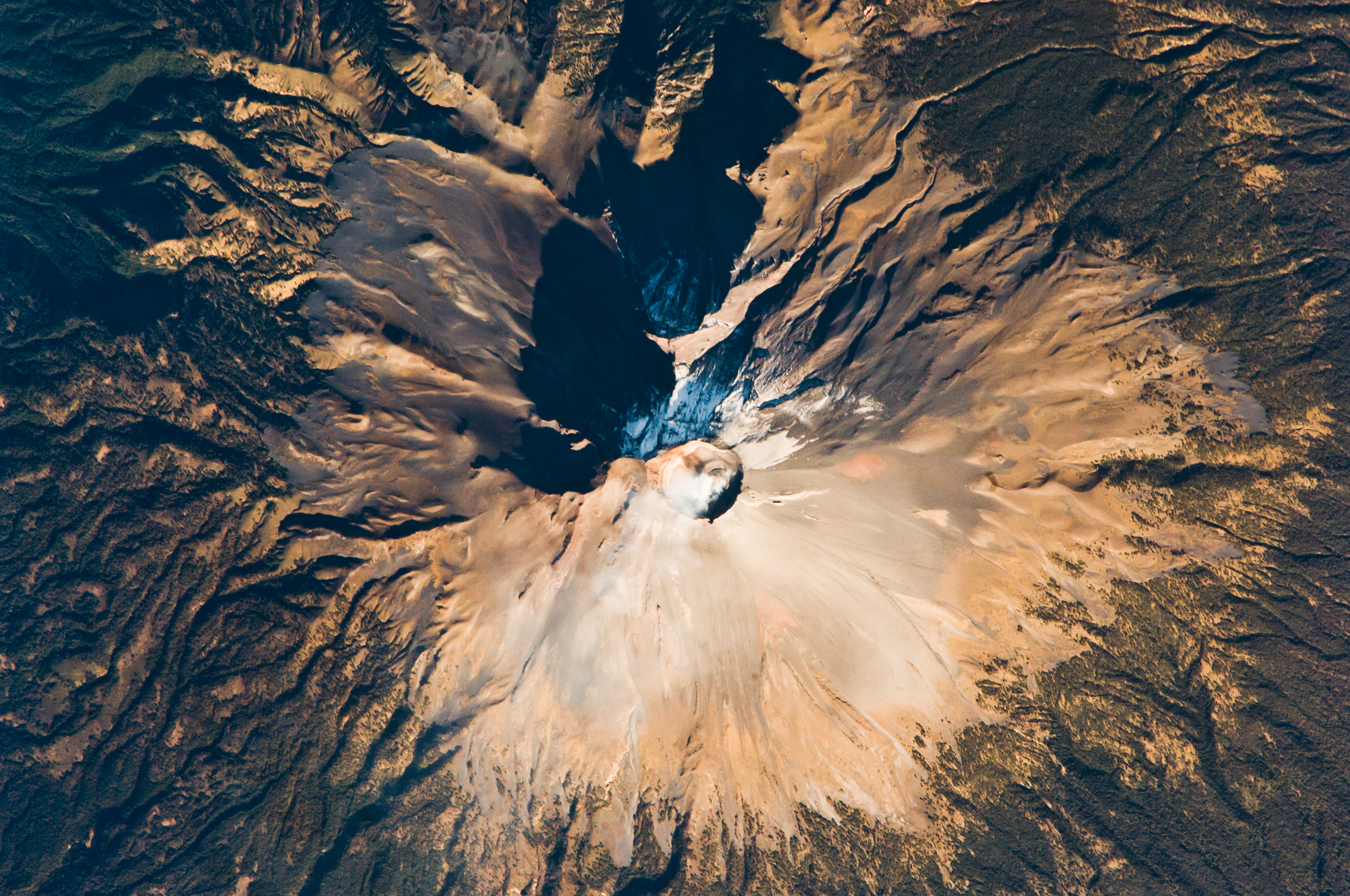
 Seen from the International Space Station in February 2009
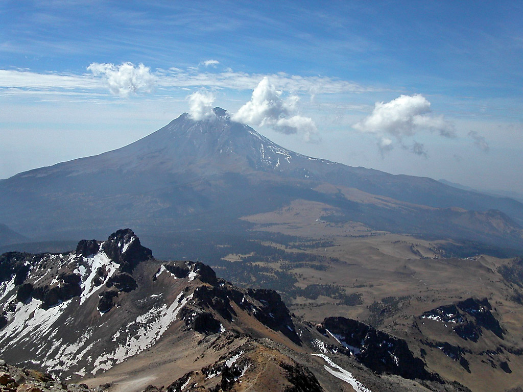
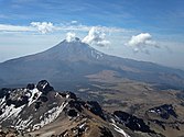 Seen from near the summit of Iztaccihuatl
 Iglesia de Nuestra Señora de los Remedios with the volcano in the background
 Popocatépetl, as viewed from Amecameca (looking south-east) (2011)


See also
- List of volcanoes in Mexico
- List of Ultras of Mexico
- Legend of Popocatépetl and Iztaccíhuatl: Pre-Hispanic legends on the origin of the two mountains
- 1949 Mexicana DC-3 crash which took place on this volcano
Notes
- Sources vary widely, on the elevation of Popocatépetl, with most giving a value at or slightly above 5,400 m (17,700 ft). The 5,426 m (17,802 ft) figure given here is from the Smithsonian Institution-Global Volcanism Program.[1]
References
- "Popocatépetl". Global Volcanism Program. Smithsonian Institution. Retrieved 2008-12-18.
- "Mexico Ultras". Peaklist.org. Retrieved 2012-01-29. The prominence value given here of 3,020 m (9,910 ft) is based on a summit elevation of 5,400 m (17,700 ft) for Popocatépetl.
- "Volcán Popocatépetl, Mexico". Peakbagger.com. Retrieved 2012-01-29. The prominence value given here of 3,020 m (9,910 ft) is interpolated from a summit elevation of 5,400 m (17,700 ft) for Popocatépetl.
- "Popocatépetl volcano". 19 Feb 2018.
- Beaman, John H. (July 1962). "The Timberlines of Iztaccihuatl and Popocatépetl, Mexico". Journal of Ecology. 43 (3): 377–385. doi:10.2307/1933367. JSTOR 1933367.
- "Parque Nacional Izta-Popo Zoquiapan". SIMEC: Sistema de Información, Monitoreo, y Evaluación para la Conservación (in Spanish). Comisión Nacional de Áreas Naturales Protegidas. 5 August 2016. Retrieved 10 October 2017.
- "Sistema de Información Geográfica". Comisión Nacional de Áreas Naturales Protegidas. Archived from the original on 27 October 2010. Retrieved 22 February 2011.
- Huggel, C.; Delgado, H. (2000). "Glacier monitoring at Popocatépetl Volcano, México: glacier shrinkage and possible causes" (PDF). In Hegg, C.; Vonder Muehll, D. (eds.). Beiträge zur Geomorphologie.- Proceedings Fachtagung der Schweizerischen Geomorphologischen Gesellschaft, 8–10 July 1999. Bramois, WSL Birmensdorf. pp. 97–106. Archived (PDF) from the original on 2022-10-09. Retrieved 2012-04-17.
- Granados HD (1997). "The glaciers of Popocatépetl volcano (Mexico): Changes and causes". Quaternary International. 43–44: 53–60. Bibcode:1997QuInt..43...53G. doi:10.1016/S1040-6182(97)00020-7. Retrieved 2012-04-17.
- Delgado Granados H, Miranda PJ, Huggel C, Ortega del Valle S, Alatorre Ibargüengoitia MA (2007). "Chronicle of a death foretold: Extinction of the small-size tropical glaciers of Popocatépetl volcano (Mexico)". Global and Planetary Change. 56 (1–2): 13–22. Bibcode:2007GPC....56...13D. doi:10.1016/j.gloplacha.2006.07.010.
- Huggel C, Schneider D, Julio Miranda P, Granados HD, Kääb A (2008). "Evaluation of ASTER and SRTM DEM data for lahar modeling: A case study on lahars from Popocatépetl Volcano, Mexico" (PDF). Journal of Volcanology and Geothermal Research. 170 (1–2): 99–110. Bibcode:2008JVGR..170...99H. doi:10.1016/j.jvolgeores.2007.09.005. S2CID 51845260. Archived from the original (PDF) on 2012-10-29. Retrieved 2012-04-17.
- Julio-Miranda P, Delgado-Granados H, Huggel C, Kääb A (2008). "Impact of the eruptive activity on glacier evolution at Popocatépetl Volcano (México) during 1994–2004" (PDF). Journal of Volcanology and Geothermal Research. 170 (1–2): 86–98. Bibcode:2008JVGR..170...86J. CiteSeerX 10.1.1.536.4620. doi:10.1016/j.jvolgeores.2007.09.011. Archived from the original (PDF) on 2012-09-15. Retrieved 2017-11-01.
- Sosa, G.; Gardner, J. E.; Lassiter, J. C. (2009). "Magma evolution during the last 23 ky at Popocatepetl Volcano: insights from Sr, Nd, and Pb isotopes in plagioclase, pyroxene and pumice matrix". Fall Meeting 2009, abstract #V51A-1658. AGU Fall Meeting Abstracts. Vol. 2009. American Geophysical Union. pp. V51A–1658. Bibcode:2009AGUFM.V51A1658S.
- Martin, A. L.; Cifuentes, G.; Straub, S.; Mendiola, F. (2007). "Magma Stagnation and Ascent at Popocatepetl Volcano, Mexico during the last 10 years". Spring Meeting 2007, abstract #V42A-05. AGU Spring Meeting Abstracts. Vol. 2007. American Geophysical Union. pp. V42A–05. Bibcode:2007AGUSM.V42A..05M.
- Romance at poetry.archive.com. Retrieved 16 June 2022
- "¿Sabes porqué al Popocatépetl se le dice Don Goyo?". Yosoypuebla. June 2016.
- "Popocatépetl volcano eruptions". VolcanoDiscovery. Retrieved 2012-04-20.
- yosoypubla.com
- Macías, José Luis (2007). "Geology and eruptive history of some active volcanoes of México". In Alaniz-Álvarez, S.A.; Nieto-Samaniego, Á.F. (eds.). Geology of México: Celebrating the Centenary of the Geological Society of México. Vol. 422. pp. 199–204. doi:10.1130/2007.2422(06). ISBN 978-0-8137-2422-5. S2CID 33648400.
- Plunket, Patricia; Uruñuela, Gabriela (1998). "Preclassic Household Patterns Preserved Under Volcanic Ash at Tetimpa, Puebla, Mexico". Latin American Antiquity. 9 (4): 287–309. doi:10.2307/3537029. JSTOR 3537029. S2CID 131051324.
- Diaz, B., 1963, The Conquest of New Spain, London: Penguin Books, ISBN 0140441239
- Zeballos, J.L.; Meli, R.; Vilchis, A.; Barrios, L. (1996). "The effects of volcanoes on health: preparedness in Mexico". World Health Statistics Quarterly. 49 (3–4): 204–208. PMID 9170236.
- Robinson, Jennifer (23 May 2016). "SECRETS OF THE DEAD: Teotihuacán's Lost Kings". kpbs.org. Retrieved 23 October 2017.
- "Residents on slopes of Popocatepetl Volcano heed evacuation notice". US Geological Survey. 2000. Retrieved 2012-04-20.
- Julio Miranda, P.; Delgado Granados, H. (2003). "Fast hazard evaluation, employing digital photogrammetry on Popocatépetl glaciers", Mexico". Geofísica Internacional. 42 (2): 275–283. doi:10.22201/igeof.00167169p.2003.42.2.271.
- "Mexican volcano hurls hot rock into sky". CBC News. 2012-04-19. Retrieved 2012-04-20.
- Greenwood, Faine (May 8, 2013). "Mexico's Popocatépetl volcano has erupted". Global Post. Archived from the original on 26 June 2013. Retrieved 9 May 2013.
- "Popocatépetl volcano (Mexico): strong ash emissions and increase of activity". Volcano Discovery. Archived from the original on 9 June 2013. Retrieved 9 May 2013.
- "US Airlines Cancel Mexico Flights Due To Volcano". Associated Press. Retrieved 4 July 2013.
- "Global Volcanism Program | Report on Popocatepetl (Mexico) — 27 August-2 September 2014". volcano.si.edu. doi:10.5479/si.GVP.WVAR20140827-341090 (inactive 31 July 2022). Retrieved 2022-01-27.
{{cite web}}: CS1 maint: DOI inactive as of July 2022 (link) - "Smithsonian / US Geological Survey Weekly Volcanic Activity Report". Smithsonian Institution and US Geological Survey. 2 September 2014.
- "Global Volcanism Program | Report on Popocatepetl (Mexico) — 7–13 January 2015". volcano.si.edu. doi:10.5479/si.GVP.WVAR20150107-341090 (inactive 31 July 2022). Retrieved 2022-01-27.
{{cite web}}: CS1 maint: DOI inactive as of July 2022 (link) - "Mexico's Popocatépetl volcano spews ash and gas into sky – video". Reuters via The Guardian. 29 March 2016. Retrieved 23 October 2017.
- "Mexico's Popocatépetl volcano violently erupts, launching burning rocks". upi.com. Retrieved 23 October 2017.
- Klemetti, Erik (18 August 2016). "Science: Here's What's Happening in This Volcanic Explosion at Guatemala's Santiaguito/Popocatépetl". Wired. Retrieved 19 August 2016.
- "Reporte del monitoreo de CENAPRED al volcán Popocatépetl hoy 15 de diciembre". 15 December 2018.
{{cite web}}: CS1 maint: url-status (link) - "Actualización de Reporte del monitoreo de CENAPRED al volcán Popocatépetl hoy 22 de enero". January 22, 2019.
{{cite web}}: CS1 maint: url-status (link) - Malkin, Elisabeth (2019-03-19). "Mexican Volcano Lights Up the Night Sky, and Social Media". The New York Times.
- "March 28, 11:00 h (March 28, 17:00 GMT)". Centro Nacional de Prevencion de Desastres. March 28, 2019. Retrieved March 29, 2019.
- "Reporte del monitoreo de CENAPRED al volcán Popocatépetl hoy 03 de junio". June 3, 2019.
{{cite web}}: CS1 maint: url-status (link) - "Reporte del monitoreo de CENAPRED al volcán Popocatépetl hoy 18 de junio". June 18, 2019.
{{cite web}}: CS1 maint: url-status (link) - "Reporte del monitoreo de CENAPRED al volcán Popocatépetl hoy 24 de junio". June 24, 2019.
{{cite web}}: CS1 maint: url-status (link) - "Popocatépetl lanza tres emisiones de ceniza" [Popocatépetl has three ash eruptons]. UNO TV (in Spanish). July 18, 2019. Retrieved July 19, 2019.
- "Reportan caída de ceniza en Xochimilco" [Ashes from Popocateptl reported in Xochimilco]. Milenio (in Spanish). Mexico City. July 20, 2019. Retrieved July 21, 2019.
- Elassar, Alaa (2019-10-05). "Mexico's Popocatépetl volcano erupted 14 times in one night". CNN. Retrieved 2019-12-06.
- "Popocatépetl: Mexico volcano forces KLM flight back to Amsterdam". BBC. 2019-11-29. Retrieved 2019-12-06.
- "Video: Mexico's Most Active Volcano Erupts, Spews Ash Cloud Nearly 20,000 Feet". NPR. 10 January 2020. Retrieved 29 January 2020.
- "Mexican volcano stages dramatic nighttime show". KYMA. 28 January 2020. Retrieved 29 January 2020.
- Kinver, Mark (2020-04-24). "Volcanic time-bomb threatens nearby trees". BBC News. Retrieved 2020-04-24.
- "Global Volcanism Program | Popocatépetl".
Further reading
- Secor, R. J. (2008). Mexico's Volcanoes: A Climbing Guide (3rd ed.). Mountaineers Books. p. 160ff. ISBN 978-0-89886-798-5.
- Yarza de la Torre, Esperanza (1971). Volcanes de México (in Spanish). Aguilar. p. 237ff.
External links
Popocatépetl
Toluca (capital) | ||
| Municipalities |
|  |
| Municipalities |
|  |
|---|---|---|
Authority control | |
|---|---|
| General |
|
| National libraries | |
На других языках
[de] Popocatépetl
Der Popocatépetl [.mw-parser-output .IPA a{text-decoration:none}popokaˈtepetl] (Nahuatl: Popōcatepētl [popoːkaˈtepeːtɬ] (= rauchender Berg)), zuweilen auch El Popo oder Don Goyo genannt, ist ein Vulkan am Rand des Hochlands von Mexiko. Er gilt als einer der aktivsten Vulkane Mexikos. Seine derzeitige Höhe beträgt je nach Quelle bis zu 5452 m. Damit ist er nach dem Citlaltépetl (5636 m, auch Pico de Orizaba) der zweithöchste Vulkan Nordamerikas sowie der zweithöchste Berg Mexikos.- [en] Popocatépetl
[es] Popocatépetl
El Popocatépetl ((español) [popokaˈtepetl] (?·i) (náhuatl) [popoːkaˈtepeːt͡ɬ] (?·i)) (en náhuatl: Popokatepetl ‘Cerro que humea’‘popoka, humear; tepetl, cerro’) es un volcán activo localizado en el centro de México. Se encuentra en los límites territoriales de los estados de Morelos, Puebla y el Estado de México. Se localiza unos 72 km al sureste de Ciudad de México, a 43 km de Puebla, a 63 km de Cuernavaca, y a 53 km de Tlaxcala.[3][fr] Popocatepetl
Le Popocatepetl, en espagnol Popocatépetl, est un volcan du Mexique situé à 70 kilomètres au sud-est de Mexico, dans les États de Puebla et de Mexico. Avec 5 426 mètres d'altitude, il est la deuxième plus haute montagne du pays après le pic d'Orizaba, un autre volcan.[it] Popocatépetl
Il Popocatépetl (nahuatl: Popōcatepētl [popoːkaˈtepeːt͡ɬ]; 5 462 m s.l.m.) è un vulcano in attività, situato nella regione di Puebla, in Messico, a 70 km a sudest di Città del Messico e solo 45 km a ovest della città di Puebla.[ru] Попокатепетль
Попокате́петль (исп. Popocatépetl, аст. Popōcatepētl) — действующий вулкан в Мексике. Название происходит от двух слов на языке науатль: попока — «дымящийся» и тепетль — «холм», то есть дымящийся холм. Входит в Поперечный вулканический пояс[2].Другой контент может иметь иную лицензию. Перед использованием материалов сайта WikiSort.org внимательно изучите правила лицензирования конкретных элементов наполнения сайта.
WikiSort.org - проект по пересортировке и дополнению контента Википедии