geo.wikisort.org - Mountains
Mont Forel is a mountain in King Christian IX Land, Sermersooq Municipality, Greenland. It is part of the Schweizerland range, also known as 'Schweizerland Alps'.[1]
| Mont Forel | |
|---|---|
 Location of Mont Forel within Greenland | |
| Highest point | |
| Elevation | 3,383 m (11,099 ft) |
| Prominence | 1,581 m (5,187 ft) |
| Listing |
|
| Coordinates | 66°56′06″N 36°47′15″W |
| Geography | |
| Location | Sermersooq, Greenland |
| Parent range | Schweizerland |

This peak is located in a popular climbing destination, together with the Watkins Range to the northeast and the Stauning Alps further north.[2]
History
The mountain was named in 1912 by Swiss geophysicist and Arctic explorer Alfred de Quervain[3] after his Greenland icecap crossing from Godhavn (Qeqertarsuaq) on the west, to Sermilik Fjord on the eastern side.[4]
Mont Forel was first climbed by a Swiss expedition of the Akademischer Alpen-Club of Zürich led by André Roch in 1938.[5][6]
Geography
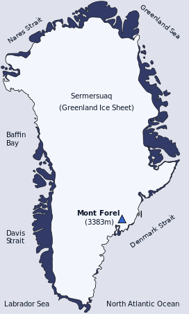
Mont Forel is the highest peak outside of the area of the Watkins Range, where the highest mountain, Gunnbjørn Fjeld, rises. It is located just north of the Arctic Circle in the Schweizerland Alps, north of Sermilik, near Ammassalik Island. Its elevation is 3,383 metres (11,099 ft) and there is an ice dome at the top of the mountain.[7] The Crown Prince Frederick Range stretches northeastwards to the northeast of Mont Forel.[8]
See also
References
- "Schweizerland". Mapcarta. Retrieved 20 June 2016.
- "Climbing and Mountaineering in Greenland". Lonely Planet. Retrieved 18 June 2016.
- Alfred de Quervain's Swiss Greenland expeditions, 1909 and 1912 in Polar Record, Cambridge Journals by William Barr
- The Swiss Expedition to Greenland 1938. André Roch
- AAJ - Greenland, Mt. Forel, Climbs And Expeditions
- Mountain Info. Greenland 2006 Climb Magazine. January 2008 issue, p. 70
- AAJ - Greenland, Mt. Forel, Climbs And Expeditions
- Climbgreenland - Mont Forel 3360 m
External links
This article related to a mountain, mountain range, or peak in Greenland is a stub. You can help Wikipedia by expanding it. |
На других языках
[de] Mont Forel
Der Mont Forel ist ein Berg im König-Christian-IX.-Land im Osten Grönlands. Er ist Teil des Schweizerland-Gebirges, auch bekannt als „Schweizerland-Alpen“.[1]- [en] Mont Forel
[fr] Mont Forel
Le mont Forel est une montagne du Groenland, située sur la côte orientale de l'île. Il tire son nom du scientifique suisse François-Alphonse Forel. Situé légèrement au nord du cercle Arctique, sur la municipalité de Sermersooq, c'est le douzième plus haut sommet de l'île, avec une altitude légèrement inférieure à 3 400 mètres. C'est aussi le plus haut sommet en dehors de la chaîne de Watkins, située sur la cote Est plus au nord et culminant au Gunnbjørn (3 700 m).[it] Monte Forel
Il monte Forel (mont Forel, 3383 m) è il 4º monte più alto della Groenlandia, dopo il monte Gunnbjørn, il Dome e il Cone. Si trova nella Terra di Re Cristiano IX, ad un centinaio di chilometri a nord del circolo polare artico; appartiene al comune di Sermersooq.[ru] Форель (гора)
Форель — вторая по высоте гора в Гренландии. Расположена на юго-востоке острова. Находится на территории Земли Короля Кристиана IX.Другой контент может иметь иную лицензию. Перед использованием материалов сайта WikiSort.org внимательно изучите правила лицензирования конкретных элементов наполнения сайта.
WikiSort.org - проект по пересортировке и дополнению контента Википедии