geo.wikisort.org - Mountains
The Watkins Range (Danish: Watkins Bjerge)[1] is Greenland's highest mountain range. It is located in King Christian IX Land, Sermersooq municipality.
| Watkins Range | |
|---|---|
| Watkins Bjerge | |
 Watkins Range | |
| Highest point | |
| Peak | Gunnbjørn Fjeld |
| Elevation | 3,649 m (11,972 ft) |
| Geography | |
 Location | |
| Country | Greenland |
| Municipality | Sermersooq |
| Range coordinates | 68°45′N 29°38′W |
The range was named after British Arctic explorer Gino Watkins.
History
Made up entirely of nunataks,[2] this remote range was formerly an unknown area. In 1912 Swiss geophysicist and Arctic explorer Alfred De Quervain crossed the Greenland ice cap from Godhavn (Qeqertarsuaq) on the west, to Sermilik Fjord on the eastern side and saw a range system that he named 'Schweizerland', marking the position and approximate height of Mont Forel, the highest point of that area[3] Lacking accurate data, Mont Forel was then thought to be the highest mountain in the Arctic Circle area, together with Petermann Peak far to the north.[4]
However, in 1930 Gino Watkins, leader of the British Arctic Air Route Expedition, discovered a new mountain range from the air located over 350 km to the northeast of Schweizerland[5] that he named 'New Mountains'.[6] This was the higher Watkins Range with the Gunnbjørnsfjeld, the actual highest summit in Greenland.[7]
In 1935 Lawrence Wager, who had been earlier with Watkins' 1930 expedition returned to East Greenland and opened a new route inland. During his venture he made the first ascent of the range's highest point, Gunnbjorns Fjeld. He was also able to sight as well the Lemon Range, a hitherto unknown range located to the north-east of Kangerlugssuaq Fjord.[4]
Geography
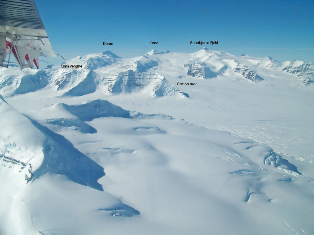
The Watkins Range is located in King Christian IX Land about 60 km inland from the Blosseville Coast. It is a system of nunataks surrounded by large active glaciers. The main glaciers are the large Christian IV Glacier to the west, the Rosenborg Glacier to the south and the Kronborg Glacier to the east.[1] The range has massive ice-covered peaks and exposed cliffs. The primary summit of the range is Gunnbjørn Fjeld 3,694 m (12,119 ft), also the highest peak in the Arctic.
The Lindbergh Range rises to the west, beyond the Christian IV Glacier. Other high nunataks are located nearby, some being part of the greater Watkins Range system, such as the Skaermen (Skærmen) to the west,[8] the Ejnar Mikkelsen Range—[9] and the Borgtinderne to the east,[10] and the Lilloise Range to the southeast.[11] The Gronau Nunataks are located to the north at the edge of the Greenland Ice Sheet, separated from the Watkins Range by the Christian IV Glacier.[12]
'Rasmussens Range' (Knud Rasmussens Bjerge), from Knud Rasmussen Land mountains, is the name used in some sources to refer to the northern section of the range located between the 69th parallel north and the Gronau Nunataks.[13] However, there is a mountain range located in West Greenland that is known by the name Knud Rasmussens Bjerge.[14]
Mountains
The Watkins Range has a number of mountains higher than 3,000 m (9,800 ft), some of which are unnamed.[15] Among these the following deserve mention:
- Gunnbjørn Fjeld - 3,694 m (12,119 ft)
- Gunnbjørn Dome - 3,682 m (12,080 ft)
- Gunnbjørn Cone - 3,669 m (12,037 ft)
- Peak - 3,606 m (11,831 ft) at 68°48′40″N 29°33′26″W, part of a group of high peaks north of Gunnbjørn Fjeld[16]
- Deception Dome - 3,526 m (11,568 ft)
- Peak - 3,344.5 m (10,973 ft) at 68°48′21″N 29°16′57″W, part of a group of high peaks NE of Gunnbjørn Fjeld[16]
- Istind - 2,667 m (8,750 ft)[17][18]
- Ebeth - 2,595 m (8,514 ft)[17]
- Lille Snefjeld - 2,511 m (8,238 ft)[17]
 Southward bend in the Christian IV Glacier with the Gronau Nunataks in the background and the NW part of the Watkins Range on the right
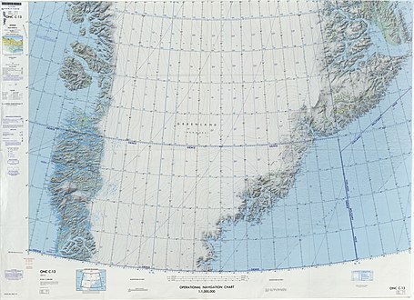 Defense Mapping Agency map of Greenland sheet


Climbing
The Watkins Range has excellent snow as well as ice routes for experienced climbers. Good climbing conditions are present for the most part in July and August.[19]
See also
- East Greenland Orogen
- List of mountain ranges of Greenland
- List of Nunataks of Greenland
References
- "Watkins Bjerge". Mapcarta. Retrieved 6 May 2016.
- GEUS Map - Northern East Greenland; Geological Survey of Denmark and Greenland Bulletin 21 Map 4 - 1:1 000 000
- Alfred de Quervain's Swiss Greenland expeditions, 1909 and 1912 in Polar Record, Cambridge Journals by William Barr
- The Development of Mountaineering in East and North-East Greenland, An Outline History
- The Swiss Expedition to Greenland 1938. André Roch
- "Catalogue of place names in northern East Greenland". Geological Survey of Denmark. Retrieved 31 July 2016.
- Encyclopedia Arctica 14: Greenland
- "Skærmen". Mapcarta. Retrieved 6 July 2016.
- "Ejnar Mikkelsen Fjeld". Mapcarta. Retrieved 23 June 2016.
- "Borgtinderne". Mapcarta. Retrieved 6 July 2016.
- "Lilloise Bjerge". Mapcarta. Retrieved 22 June 2016.
- "Gronau Nunatakker". Mapcarta. Retrieved 26 June 2016.
- Arctic Summits - Summit Climbs
- Geonames - Knud Rasmussen Bjerge
- "Watkins Mountains". Petter Bjørstad. Retrieved 6 May 2016.
- Google Earth
- "G4 Expedition, Watkins Mountains". Greenland Mountains. Retrieved 29 July 2016.
- AAJ - North America, Greenland, Swiss East Greenland Expedition
- Mountain Info. Greenland 2006 Climb Magazine. January 2008 issue, p. 70
External links
- AAJ - 2011: Mt. Augustine Courtauld (ca 3,150m).
- Highlights and keywords from the Greenland 2004 expedition
- Greenland 2004
На других языках
[de] Watkins-Gebirge
Das Watkins-Gebirge (englisch Watkins Mountains oder Watkins Range; dänisch Watkins Bjerge) ist ein Gebirge an der Blosseville-Küste im Südosten von Grönland. Das Gebirge umfasst die zehn höchsten Gipfel der Arktis, darunter den mit 3694 m höchsten Gipfel, Gunnbjørns Fjeld. Die etwas niedrigeren Gipfel Qaqqaq Kershaw und Qaqqaq Johnson bilden mit 3682 m bzw. 3669 m die zweit- und dritthöchsten Erhebungen.[1] Das Gebirge ist nach dem britischen Polarforscher Gino Watkins benannt.- [en] Watkins Range
[es] Cordillera Watkins
La cordillera Watkins (en danés, Watkins Bjerge[1]) es la cordillera más alta de Groenlandia. Está situada en la Tierra del Rey Christian IX, en el municipio de Sermersooq. La cordillera lleva el nombre del explorador británico del Ártico Gino Watkins .[fr] Chaîne de Watkins
La chaîne de Watkins est une chaîne de montagnes du Groenland culminant à 3 700 mètres d'altitude au Gunnbjørn, le plus haut sommet de l'île. Elle est survolée en 1930 par Gino Watkins et nommée en son honneur.Другой контент может иметь иную лицензию. Перед использованием материалов сайта WikiSort.org внимательно изучите правила лицензирования конкретных элементов наполнения сайта.
WikiSort.org - проект по пересортировке и дополнению контента Википедии