geo.wikisort.org - Mountains
The list of peaks in Rocky Mountain National Park includes the following:[1]
| Trailhead | Image | Peak | Height | Location |
|---|---|---|---|---|
| Bear Lake |  | Flattop Mountain | 12,326 ft / 3,757 m | 40.309°N 105.690°W[2] |
| Bear Lake |  | Hallett Peak | 12,598 ft / 3,840 m | 40.303°N 105.686°W[3] |
| Bear Lake |  | Hayden Spire | 12,421 ft / 3,786 m | 40.351°N 105.740°W[4] |
| Bear Lake | Knobtop Mountain | 12,336 ft / 3,760 m | 40.324°N 105.701°W[5] | |
| Bear Lake | 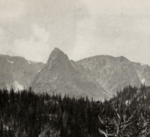 | Little Matterhorn | 11,532 ft / 3,515 m | 40.327°N 105.692°W[6] |
| Bear Lake | Notchtop Mountain | 11,929/ ft / 3,636 m | 40.318°N 105.694°W[7] | |
| Bear Lake | Ptarmigan Point | 12,270 ft / 3,740 m | 40.313°N 105.701°W[8] | |
| Bear Lake | Snowdrift Peak | 12,205 ft / 3,720 m | 40.310°N 105.743°W[9] | |
| Chapin Pass | Desolation Peaks | 12,674 ft / 3,863 m | 40.472°N 105.693°W[10] | |
| Chapin Pass |  | Mount Chapin | 12,438 ft / 3,791 m | 40.433°N 105.701°W[11] |
| Chapin Pass |  | Mount Chiquita (center) | 13,051 ft / 3,978 m | 40.443°N 105.688°W[12] |
| Chapin Pass | 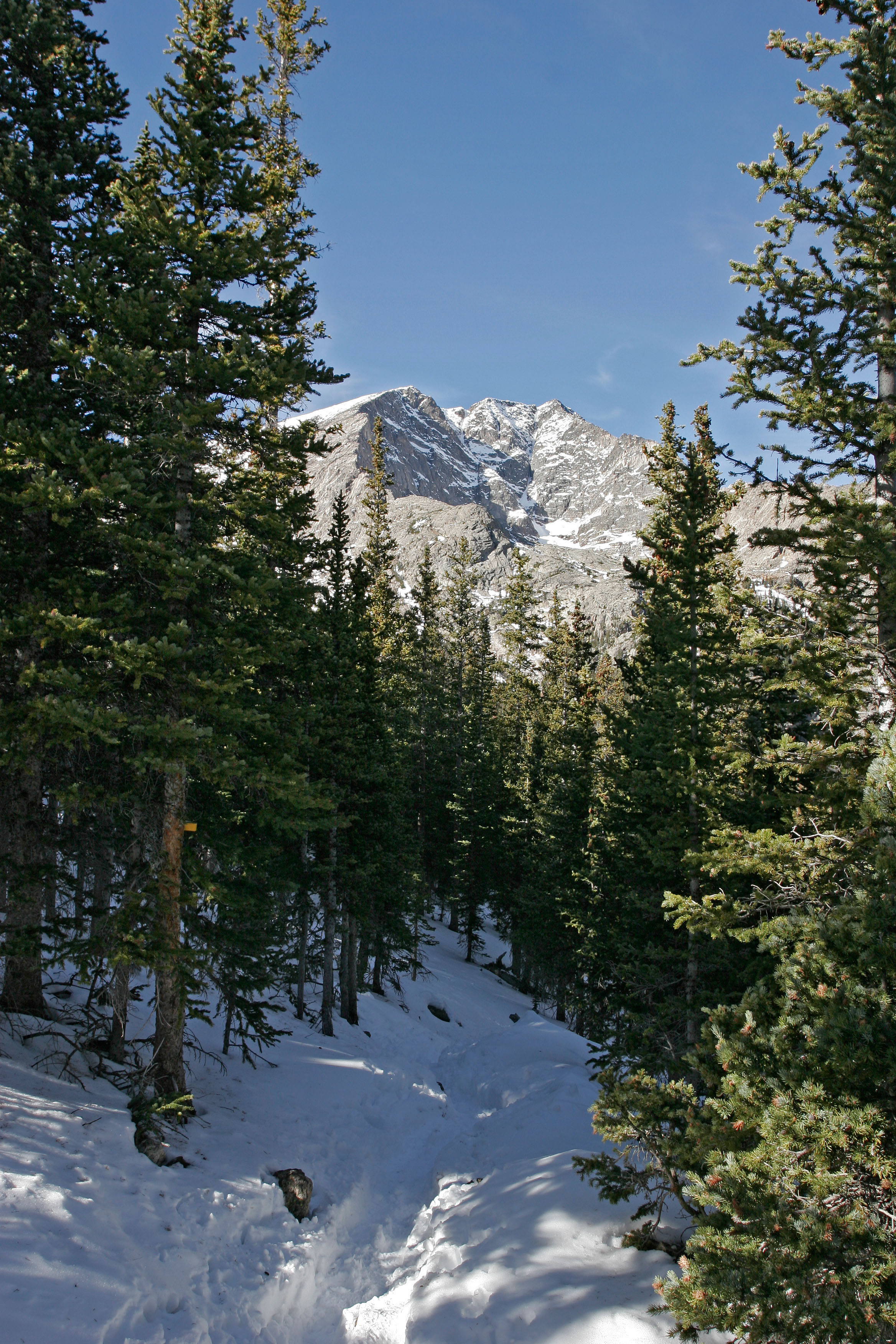 | Ypsilon Mountain | 13,445 ft / 4,098 m | 40.456°N 105.681°W[13] |
| Colorado River | Howard Mountain | 12,762 ft / 3,890 m | 40.426°N 105.898°W[14] | |
| Colorado River |  | Lead Mountain | 12,474 ft / 3,802 m | 40.448°N 105.897°W[15] |
| Colorado River | Lulu Mountain | 12,201 ft / 3,719 m | 40.479°N 105.862°W[16] | |
| Colorado River | Mount Cirrus | 12,730 ft / 3,880 m | 40.434°N 105.901°W[17] | |
| Colorado River | Mount Cumulus | 12,733 ft / 3,881 m | 40.410°N 105.902°W[18] | |
| Colorado River | Mount Nimbus | 12,644 ft / 3,854 m | 40.396°N 105.904°W[19] | |
| Cow Creek | Dark Mountain | 10,827 ft / 3,300 m | 40.432°N 105.5719°W[20] | |
| Emmaline Lake | Comanche Peak | 12,690 ft / 3,868 m | 40.548°N 105.677°W[21] | |
| Emmaline Lake | Fall Mountain | 12,257 ft / 3,736 m | 40.528°N 105.661°W[22] | |
| Fern Lake | Stones Peak | 12,894 ft / 3,930 m | 40.354°N 105.721°W[23] | |
| Glacier Gorge | Arrowhead | 12,651 ft / 3,856 m | 40.268°N 105.650°W[24] | |
| Glacier Gorge | Chiefs Head Peak | 13,579 ft / 4,121 m | 40.249°N 105.641°W[25] | |
| Glacier Gorge | Half Mountain | 11,437 ft / 3,486 m | 40.290°N 105.633°W[26] | |
| Glacier Gorge | McHenrys Peak | 13,327 ft / 4,062 m | 40.263°N 105.658°W[27] | |
| Glacier Gorge | Otis Peak | 12,444 ft / 3,793 | 40.292°N 105.680°W[28] | |
| Glacier Gorge | Pagoda Mountain | 13,392 ft / 4,082 m | 40.251°N 105.626°W[29] | |
| Glacier Gorge |  | Petit Grepon | 12,000 ft / 3,658 m | 40.280°N 105.673°W[30] |
| Glacier Gorge |  | Powell Peak | 13,149 ft / 4,008 m | 40.2658°N 105.6647°W[31] |
| Glacier Gorge | The Sharkstooth | 12,411 ft / 3,783 m | 40.280°N 105.674°W[32] | |
| Glacier Gorge | The Spearhead | 12,533 ft / 3,820 m | 40.255°N 105.638°W[33] | |
| Glacier Gorge |  | Taylor Peak | 13,117 ft / 3,998 m | 40.274°N 105.680°W[34] |
| Glacier Gorge | Thatchtop | 12,657 ft / 3,858 m | 40.279°N 105.653°W[35] | |
| Green Mountain | Nakai Peak | 11,916 ft / 3,632 m | 40.346°N 105.776°W[36] | |
| Green Mountain | Sprague Mountain | 12,697 ft / 3,870 m | 40.347°N 105.736°W[37] | |
| Lake Agnes |  | Mount Richthofen | 12,890 ft / 3,929 m | 40.469°N 105.895°W[38] |
| Lake Agnes |  | Static Peak | 12,575 ft / 3,833 m | 40.477°N 105.892°W[39] |
| Lake Agnes | Tepee Mountain | 12,306 ft / 3,751 m | 40.463°N 105.899°W[40] | |
| Lawn Lake |  | Fairchild Mountain | 13,508 ft / 4,116 m | 40.468°N 105.664°W[41] |
| Lawn Lake |  | Hagues Peak | 13,570 ft / 4,096 m | 40.485°N 105.646°W[42] |
| Lawn Lake |  | Mummy Mountain | 13,382 ft / 4,079 m | 40.476°N 105.626°W[43] |
| Lawn Lake | Rowe Peak | 13,399 ft / 4,084 m | 40.490°N 105.645°W[44] | |
| Longs Peak | Estes Cone | 11,010 ft / 3,356 m | 40.295°N 105.567°W[45] | |
| Longs Peak |  | Longs Peak | 14,258 ft / 4,346 m | 40.255°N 105.616°W[46] |
| Longs Peak | Mount Lady Washington | 13,245 ft / 4,037 m | 40.263°N 105.607°W[47] | |
| Longs Peak |  | Mount Meeker (left) | 13,868 ft / 4,227 m | 40.249°N 105.605°W[48] |
| Longs Peak | Storm Peak | 13,320 ft / 4,060 m | 40.266°N 105.6205°W[49] | |
| Lumpy Ridge | Lumpy Ridge / The Needles | 10,059 ft / 3,066 m | 40.416°N 105.551°W[50] | |
| Meeker Park | Horsetooth Peak | 10,341 ft / 3,152 m | 40.232°N 105.560°W[51] | |
| Meeker Park | Lookout Mountain | 10,702 ft / 3,262 m | 40.227°N 105.565°W[52] | |
| Milner Pass | Chief Cheley Peak | 12,815 ft / 3,906 m | 40.367°N 105.774°W[53] | |
| Milner Pass | Cracktop | 12,762 ft / 3,890 m | 40.366°N 105.766°W[54] | |
| Milner Pass |  | Mount Ida | 12,844 ft / 3,915 m | 40.372°N 105.779°W[55] |
| Milner Pass |  | Mount Julian | 12,920 ft / 3,938 m | 40.371°N 105.758°W[56] |
| Milner Pass |  | Terra Tomah Mountain | 12,693 ft / 3,869 m | 40.3763°N 105.750°W[57] |
| Saint Vrain Mountain | Meadow Mountain | 11,634 ft / 3,546 m | 40.175°N 105.570°W[58] | |
| Saint Vrain Mountain | Saint Vrain Mountain | 12,149 ft / 3,703 m | 40.161°N 105.585°W[59] | |
| Stormy Peaks | Stormy Peaks | 12,113 ft / 3,692 m | 40.520°N 105.587°W[60] | |
| Trail Ridge Road |  | Sundance Mountain | 12,447 ft / 3,794 m | 40.408°N 105.711°W[61] |
| Twin Sisters |  | Twin Sisters Peaks | 11,332 ft / 3,454 m | 40.289°N 105.518°W[62] |
| Wild Basin | Copeland Mountain | 13,166 ft / 4,013 m | 40.182°N 105.646°W[63] | |
| Wild Basin | Elk Tooth | 12,848 ft / 3,916 m | 40.168°N 105.654°W[64] | |
| Wild Basin | Isolation Peak | 13,067 ft / 3,983 m | 40.203°N 105.677°W[65] | |
| Wild Basin | Mount Alice | 13,281 ft / 4,048 m | 40.239°N 105.663°W[66] | |
| Wild Basin | Ogalalla Peak | 13,081 ft / 3,987 m | 40.170°N 105.667°W[67] | |
| Wild Basin | Ouzel Peak | 12,677 ft / 3,864 m | 40.186°N 105.671°W[68] | |
| Wild Basin | Pilot Mountain | 12,113 ft / 3,692 m | 40.231°N 105.658°W[69] | |
| Wild Basin | The Cleaver | 12,178 / 3,712 | 40.217°N 105.671°W [70] | |
| Map |
|---|
| Create a map of all Rocky Mountain National Park peak coordinates using this OpenStreetMap (OSM) link |
References
- "Rocky Mountain National Park - Trailheads and Peaks". Summit Post. Retrieved October 31, 2016.
- "Flattop Mountain". Geographic Names Information System. United States Geological Survey. October 13, 1978. Retrieved November 1, 2016.
- "Hallett Peak". Geographic Names Information System. United States Geological Survey. October 13, 1978. Retrieved November 1, 2016.
- "Hayden Spire". Geographic Names Information System. United States Geological Survey. October 13, 1978. Retrieved November 1, 2016.
- "Knobtop Mountain". Geographic Names Information System. United States Geological Survey. October 13, 1978. Retrieved November 1, 2016.
- "Little Matterhorn". Geographic Names Information System. United States Geological Survey. October 13, 1978. Retrieved November 1, 2016.
- "Notchtop Mountain". Geographic Names Information System. United States Geological Survey. October 13, 1978. Retrieved November 1, 2016.
- "Ptarmigan Point". Geographic Names Information System. United States Geological Survey. October 13, 1978. Retrieved November 1, 2016.
- "Snowdrift Peak". Geographic Names Information System. United States Geological Survey. October 13, 1978. Retrieved November 1, 2016.
- "Desolation Peaks". Geographic Names Information System. United States Geological Survey. October 13, 1978. Retrieved November 1, 2016.
- "Mount Chapin". Geographic Names Information System. United States Geological Survey. October 13, 1978. Retrieved November 1, 2016.
- "Mount Chiquita". Geographic Names Information System. United States Geological Survey. October 13, 1978. Retrieved November 1, 2016.
- "Ypsilon Mountain". Geographic Names Information System. United States Geological Survey. October 13, 1978. Retrieved November 1, 2016.
- "Howard Mountain". Geographic Names Information System. United States Geological Survey. October 13, 1978. Retrieved November 1, 2016.
- "Lead Mountain". Geographic Names Information System. United States Geological Survey. October 13, 1978. Retrieved November 1, 2016.
- "Lulu Mountain". Geographic Names Information System. United States Geological Survey. October 13, 1978. Retrieved November 1, 2016.
- "Mount Cirrus". Geographic Names Information System. United States Geological Survey. October 13, 1978. Retrieved November 3, 2016.
- "Mount Cumulus". Geographic Names Information System. United States Geological Survey. October 13, 1978. Retrieved November 3, 2016.
- "Mount Nimbus". Geographic Names Information System. United States Geological Survey. October 13, 1978. Retrieved November 7, 2016.
- "Dark Mountain". Geographic Names Information System. United States Geological Survey. October 13, 1978. Retrieved November 7, 2016.
- "Comanche Peak". Geographic Names Information System. United States Geological Survey. October 13, 1978. Retrieved November 7, 2016.
- "Fall Mountain". Geographic Names Information System. United States Geological Survey. October 13, 1978. Retrieved November 7, 2016.
- "Stones Peak". Geographic Names Information System. United States Geological Survey. October 13, 1978. Retrieved November 7, 2016.
- "Arrowhead". Geographic Names Information System. United States Geological Survey. October 13, 1978. Retrieved November 7, 2016.
- "Chiefs Head Peak". Geographic Names Information System. United States Geological Survey. October 13, 1978. Retrieved November 7, 2016.
- "Half Mountain". Geographic Names Information System. United States Geological Survey. October 13, 1978. Retrieved November 7, 2016.
- "McHenrys Peak". Geographic Names Information System. United States Geological Survey. October 13, 1978. Retrieved November 7, 2016.
- "Otis Peak". Geographic Names Information System. United States Geological Survey. October 13, 1978. Retrieved November 7, 2016.
- "Pagoda Mountain". Geographic Names Information System. United States Geological Survey. October 13, 1978. Retrieved November 7, 2016.
- "Petit Grepon", Google maps, retrieved November 10, 2016
- "Powell Peak". Geographic Names Information System. United States Geological Survey. October 13, 1978. Retrieved November 8, 2016.
- "The Sharkstooth". Geographic Names Information System. United States Geological Survey. October 13, 1978. Retrieved November 8, 2016.
- "The Spearhead". Geographic Names Information System. United States Geological Survey. October 13, 1978. Retrieved November 8, 2016.
- "Taylor Peak". Geographic Names Information System. United States Geological Survey. October 13, 1978. Retrieved November 8, 2016.
- "Thatchtop". Geographic Names Information System. United States Geological Survey. October 13, 1978. Retrieved November 8, 2016.
- "Nakai Peak". Geographic Names Information System. United States Geological Survey. October 13, 1978. Retrieved November 8, 2016.
- "Sprague Mountain". Geographic Names Information System. United States Geological Survey. October 13, 1978. Retrieved November 8, 2016.
- "Mount Richthofen". Geographic Names Information System. United States Geological Survey. October 13, 1978. Retrieved November 8, 2016.
- "Static Peak". Geographic Names Information System. United States Geological Survey. October 13, 1978. Retrieved November 8, 2016.
- "Tepee Mountain". Geographic Names Information System. United States Geological Survey. October 13, 1978. Retrieved November 8, 2016.
- "Fairchild Mountain". Geographic Names Information System. United States Geological Survey. October 13, 1978. Retrieved November 9, 2016.
- "Hagues Peak". Geographic Names Information System. United States Geological Survey. October 13, 1978. Retrieved November 9, 2016.
- "Mummy Mountain". Geographic Names Information System. United States Geological Survey. October 13, 1978. Retrieved November 9, 2016.
- "Rowe Peak". Geographic Names Information System. United States Geological Survey. October 13, 1978. Retrieved November 9, 2016.
- "Estes Cone". Geographic Names Information System. United States Geological Survey. October 13, 1978. Retrieved November 10, 2016.
- "Longs Peak". Geographic Names Information System. United States Geological Survey. October 13, 1978. Retrieved November 10, 2016.
- "Mount Lady Washington". Geographic Names Information System. United States Geological Survey. October 13, 1978. Retrieved November 10, 2016.
- "Mount Meeker". Geographic Names Information System. United States Geological Survey. October 13, 1978. Retrieved November 10, 2016.
- "Storm Peak". Geographic Names Information System. United States Geological Survey. October 13, 1978. Retrieved November 10, 2016.
- "The Needles". Geographic Names Information System. United States Geological Survey. October 13, 1978. Retrieved November 10, 2016.
- "Horsetooth Peak". Geographic Names Information System. United States Geological Survey. October 13, 1978. Retrieved November 10, 2016.
- "Lookout Mountain". Geographic Names Information System. United States Geological Survey. October 13, 1978. Retrieved November 10, 2016.
- "Chief Cheley Peak". Geographic Names Information System. United States Geological Survey. October 13, 1978. Retrieved November 10, 2016.
- "Cracktop". Geographic Names Information System. United States Geological Survey. October 13, 1978. Retrieved November 10, 2016.
- "Mount Ida". Geographic Names Information System. United States Geological Survey. October 13, 1978. Retrieved November 10, 2016.
- "Mount Julian". Geographic Names Information System. United States Geological Survey. October 13, 1978. Retrieved November 10, 2016.
- "Terra Tomah Mountain". Geographic Names Information System. United States Geological Survey. October 13, 1978. Retrieved November 10, 2016.
- "Meadow Mountain". Geographic Names Information System. United States Geological Survey. October 13, 1978. Retrieved November 10, 2016.
- "Saint Vrain Mountain". Geographic Names Information System. United States Geological Survey. October 13, 1978. Retrieved November 10, 2016.
- "Stormy Peaks". Geographic Names Information System. United States Geological Survey. October 13, 1978. Retrieved November 10, 2016.
- "Sundance Mountain". Geographic Names Information System. United States Geological Survey. October 13, 1978. Retrieved November 10, 2016.
- "Twin Sisters Peaks". Geographic Names Information System. United States Geological Survey. October 13, 1978. Retrieved November 10, 2016.
- "Copeland Mountain". Geographic Names Information System. United States Geological Survey. October 13, 1978. Retrieved November 10, 2016.
- "Elk Tooth". Geographic Names Information System. United States Geological Survey. October 13, 1978. Retrieved November 10, 2016.
- "Isolation Peak". Geographic Names Information System. United States Geological Survey. October 13, 1978. Retrieved November 10, 2016.
- "Mount Alice". Geographic Names Information System. United States Geological Survey. October 13, 1978. Retrieved November 10, 2016.
- "Ogalalla Peak". Geographic Names Information System. United States Geological Survey. October 13, 1978. Retrieved November 10, 2016.
- "Ouzel Peak". Geographic Names Information System. United States Geological Survey. October 13, 1978. Retrieved November 10, 2016.
- "Pilot Mountain". Geographic Names Information System. United States Geological Survey. October 13, 1978. Retrieved November 10, 2016.
- "The Cleaver". Geographic Names Information System. United States Geological Survey. October 13, 1978. Retrieved November 10, 2016.
Текст в блоке "Читать" взят с сайта "Википедия" и доступен по лицензии Creative Commons Attribution-ShareAlike; в отдельных случаях могут действовать дополнительные условия.
Другой контент может иметь иную лицензию. Перед использованием материалов сайта WikiSort.org внимательно изучите правила лицензирования конкретных элементов наполнения сайта.
Другой контент может иметь иную лицензию. Перед использованием материалов сайта WikiSort.org внимательно изучите правила лицензирования конкретных элементов наполнения сайта.
2019-2025
WikiSort.org - проект по пересортировке и дополнению контента Википедии
WikiSort.org - проект по пересортировке и дополнению контента Википедии