geo.wikisort.org - Mountains
This article comprises four sortable tables of mountain summits of the United States that are higher than any other point north or south of their latitude or east or west of their longitude in the U.S.
The summit of a mountain or hill may be measured in three principal ways:
- The topographic elevation of a summit measures the height of the summit above a geodetic sea level.[1][2]
- The topographic prominence of a summit is a measure of how high the summit rises above its surroundings.[3][4][2]
- The topographic isolation (or radius of dominance) of a summit measures how far the summit lies from its nearest point of equal elevation.[5]
Northernmost high summits
| Rank | Mountain peak | State | Mountain range | Elevation | Prominence | Isolation | Location |
|---|---|---|---|---|---|---|---|
| 6 | Mount Chamberlin[6][7][lower-alpha 1][lower-alpha 2] | Brooks Range | 8,901 ft 2713 m | 4,151 ft 1265 m | 27.2 mi 43.9 km |
69.2775°N 144.9107°W | |
| 5 | Mount Isto[8][9][lower-alpha 3][lower-alpha 4] | Brooks Range | 8,976 ft 2736 m | 7,901 ft 2408 m | 394 mi 634 km |
69.2025°N 143.8020°W | |
| 4 | Hess Mountain[10][11][lower-alpha 5] | Alaska Range | 11,940 ft 3639 m | 2,490 ft 759 m | 2.78 mi 4.47 km |
63.6382°N 147.1482°W | |
| 3 | Mount Deborah[12][13][lower-alpha 6] | Alaska Range | 12,339 ft 3761 m | 5,189 ft 1582 m | 16.08 mi 25.9 km |
63.6377°N 147.2384°W | |
| 2 | Mount Hayes[14][15][lower-alpha 7][lower-alpha 8] | Alaska Range | 13,832 ft 4216 m | 11,507 ft 3507 m | 125.5 mi 202 km |
63.6203°N 146.7178°W | |
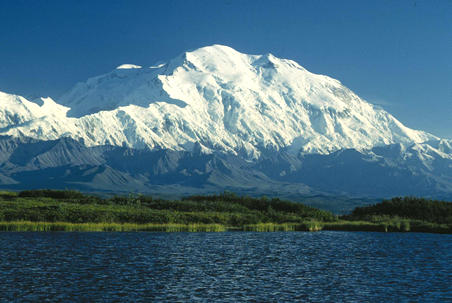
| 1 | Denali[16][17][lower-alpha 9] (Mount McKinley) |
Alaska Range | 20,310 ft 6190.5 m | 20,146 ft 6141 m | 7,450.24 | 63.0690°N 151.0063°W |
Southernmost high summits
Easternmost high summits
Westernmost high summits
Gallery
 Denali in Alaska is the highest summit of the United States and all of North America.
 Mount Saint Elias is the second highest summit of both Canada and the United States.
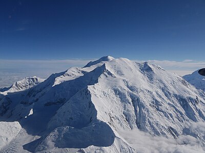 Mount Foraker is the second highest major summit of the Alaska Range.
 Mount Fairweather lies on the Alaska-British Columbia international border.
 Mount Whitney highest summit of the Sierra Nevada and California.
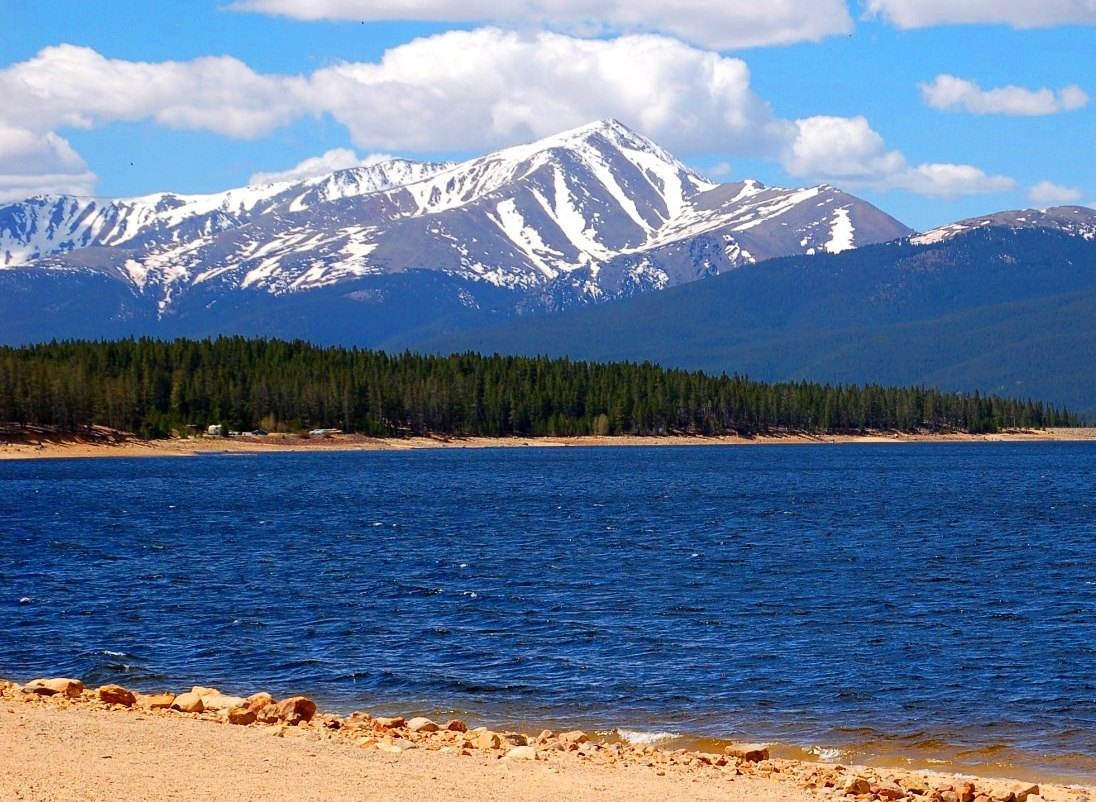
 Mount Elbert is the highest summit of Colorado and the Rocky Mountains.
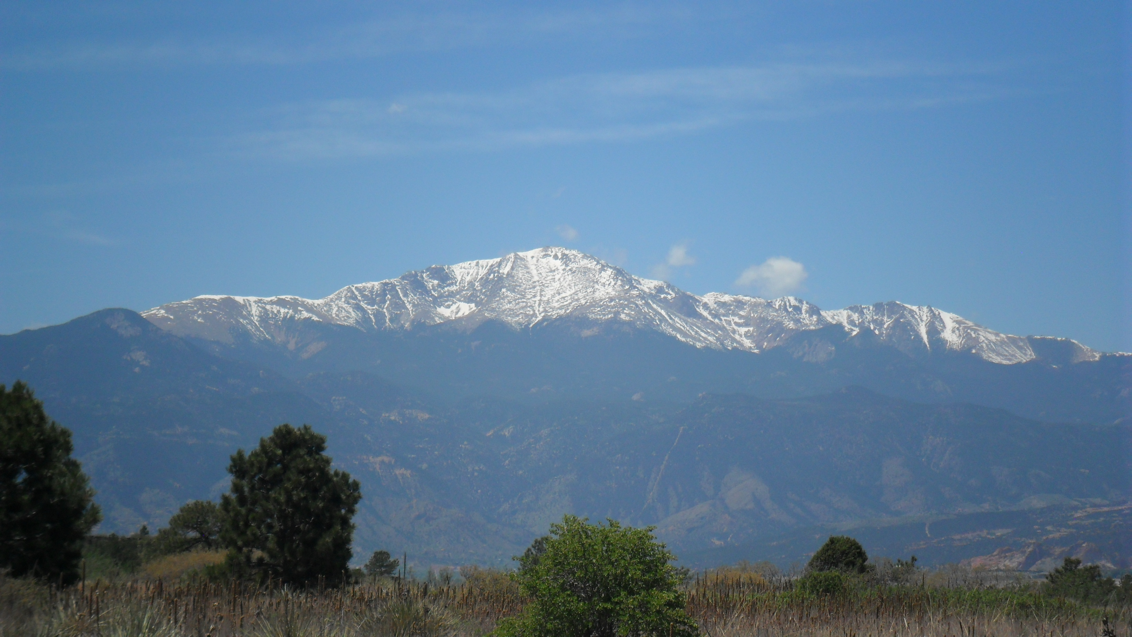
 Pikes Peak in Colorado was the inspiration for America the Beautiful.
 Mount Hayes is the highest summit of the eastern Alaska Range.
 Mauna Kea on the Island of Hawaiʻi is the tallest mountain on Earth as measured from base to summit.
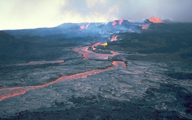
 Mauna Loa on the Island of Hawaiʻi is the most voluminous mountain on Earth.
 Haleakalā is the highest summit of the Island of Maui.
 Mount Vsevidof is the highest summit of Umnak Island and the Fox Islands in the Aleutian Islands of Alaska.
 Mount Mitchell is the highest summit of North Carolina and the Appalachian Mountains.
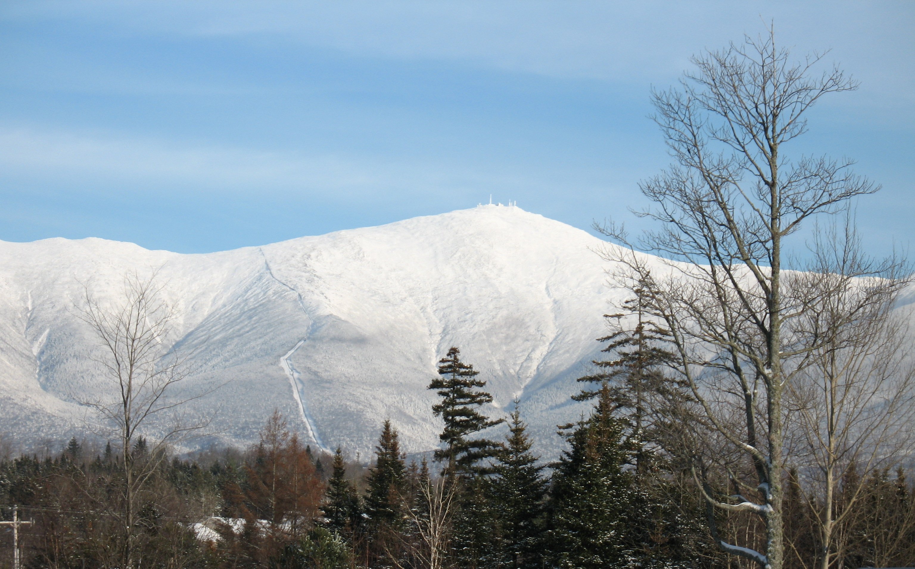
 Mount Washington is the highest summit of the White Mountains and New Hampshire.
 Tanaga Volcano is the highest summit of Tanaga Island and the Andreanof Islands in the Aleutian Islands of Alaska.
 Katahdin is the highest summit of the Longfellow Mountains and the U.S. State of Maine.
 Kiska Volcano is the apex of Kiska Island in the Aleutian Islands of Alaska.
 Buldir Volcano is the apex of Buldir Island in the Aleutian Islands of Alaska.


See also
- List of mountain peaks of North America
- List of mountain peaks of Greenland
- List of mountain peaks of Canada
- List of mountain peaks of the Rocky Mountains
- List of mountain peaks of the United States
- List of the highest major summits of the United States
- List of the major 4000-meter summits of the United States
- List of the major 3000-meter summits of the United States
- List of United States fourteeners
- List of the most prominent summits of the United States
- List of the ultra-prominent summits of the United States
- List of the most isolated major summits of the United States
- List of the major 100-kilometer summits of the United States
- List of extreme summits of the United States
- List of mountain peaks of Alaska
- List of mountain peaks of California
- List of mountain peaks of Colorado
- List of mountain peaks of Hawaiʻi
- List of mountain peaks of Montana
- List of mountain peaks of Nevada
- List of mountain peaks of Utah
- List of mountain peaks of Washington (state)
- List of mountain peaks of Wyoming
- List of the highest major summits of the United States
- List of mountain peaks of México
- List of mountain peaks of Central America
- List of mountain peaks of the Caribbean
- United States of America
- Geography of the United States
- Geology of the United States
- Category:Mountains of the United States
- Physical geography
- Topography
- Topographic elevation
- Topographic prominence
- Topographic isolation
- Topography
Notes
- The summit of Mount Chamberlin is the highest point of the Franklin Mountains.
- Mount Chamberlin is the northernmost 2000-meter (6562-foot) summit of Alaska and the United States.
- The summit of Mount Isto is the highest point of the Brooks Range.
- Mount Isto is the northernmost ultra-prominent summit of Alaska and the United States.
- Hess Mountain is the northernmost 3000-meter (9843-foot) summit of Alaska and the United States.
- Mount Deborah is the northernmost summit of its elevation in Alaska, the United States, and greater North America.
- The summit of Mount Hayes is the highest point of the Hayes Range.
- Mount Hayes is the northernmost 4000-meter (13,123-foot) summit of Alaska, the United States, and greater North America.
- The summit of Denali is the highest point of the Alaska Range, the State of Alaska, the United States of America, and greater North America. Denali is the third most topographically prominent and third most topographically isolated summit on Earth after Mount Everest and Aconcagua.
- Mauna Loa is the southernmost and westernmost 4000-meter (13,123-foot) summit of Hawaiʻi and the United States.
- The shield volcano Mauna Loa is the most voluminous mountain on Earth with an estimated volume of 74,000 km³ (17,800 cubic miles), or enough material to fill the Grand Canyon more than 18 times.
- The summit of Mauna Kea is the highest point of the Island of Hawaiʻi, the U.S. State of Hawaiʻi, and all islands of the Pacific Ocean.
- Mauna Kea is the tallest mountain on Earth as measured from base to summit. The shield volcano sits on the ocean floor at a depth of 5998 meters (19,678 feet) for a total height of 10,205.3 meters (33,482 feet).
- The summit of Mount Kaweah is the highest point of the Great Western Divide.
- Mount Kaweah is the southernmost summit of its elevation in United States.
- The elevation of Mount Kaweah includes an adjustment of +1.652 m (5.42 ft) from NGVD 29 to NAVD 88.
- The summit of Mount Whitney is the highest point of the Sierra Nevada, the State of California, and the contiguous United States.
- Mount Whitney is the southernmost and easternmost summit of its elevation in United States.
- Mount Fairweather lies on the international border between Alaska and British Columbia. The peak is the highest point of the Canadian Province of British Columbia and the southernmost and easternmost summit of its elevation in both Canada and the United States.
- Mount Saint Elias is the second highest major summit of both Canada and the United States.
- The summit of Katahdin is the highest point of the Longfellow Mountains and the U.S. State of Maine.
- Katahdin is the easternmost 1000-meter (3281-foot) summit of the United States.
- The summit of Mount Washington is the highest point of the White Mountains, the State of New Hampshire, and the northeastern United States.
- Mount Washington is the easternmost ultra-prominent summit of the United States.
- The elevation of Mount Washington includes an adjustment of +0.02 m (0.07 ft) from NGVD 29 to NAVD 88.
- The summit of Mount Mitchell is the highest point of the Appalachian Mountains, the State of North Carolina, and the eastern United States.
- Mount Mitchell is the easternmost 2000-meter (6562-foot) summit of the United States.
- The elevation of Mount Mitchell includes an adjustment of +0.025 m (0.08 ft) from NGVD 29 to NAVD 88.
- The summit of Emory Peak is the highest point of the Chisos Mountains.
- Emory Peak is the easternmost summit of its elevation in the United States.
- The summit of Baldy Peak is the highest point of the Davis Mountains.
- Baldy Peak is the easternmost summit of its elevation in the United States.
- The summit of Fishers Peak is the highest point of Raton Mesa.
- Fishers Peak is the easternmost summit of its elevation in the Rocky Mountains and the United States.
- East Spanish Peak is the easternmost 3000-meter (9843-foot) summit of the Rocky Mountains and the United States.
- The elevation of East Spanish Peak includes an adjustment of +1.372 m (4.5 ft) from NGVD 29 to NAVD 88.
- West Spanish Peak is the easternmost 4000-meter (13,123-foot) summit of the Rocky Mountains and the United States.
- The elevation of West Spanish Peak includes an adjustment of +1.468 m (4.82 ft) from NGVD 29 to NAVD 88.
- Pikes Peak is the easternmost 14,000-foot (4267-meter) summit and ultra-prominent summit of the Rocky Mountains. Pikes Peak was the inspiration for the lyrics of America the Beautiful.
- The summit of Blanca Peak is the highest point of the Sangre de Cristo Mountains and the entire Rio Grande drainage basin.
- Blanca Peak is the southernmost ultra-prominent summit of the Rocky Mountains.
- The elevation of Blanca Peak includes an adjustment of +1.755 m (5.76 ft) from NGVD 29 to NAVD 88.
- The summit of Mount Harvard is the highest point of the Collegiate Peaks.
- Mount Harvard is the southernmost and easternmost summit of its elevation in the Rocky Mountains.
- The summit of Mount Elbert is the highest point of the U.S. State of Colorado, the Rocky Mountains of North America, and the entire Mississippi River drainage basin.
- The summit of Buldir Volcano is the highest point of Buldir Island.
- Buldir Volcano is the westernmost 500-meter (1640-foot) summit of Alaska, the United States, and greater North America.
- The summit of Kiska Volcano is the highest point of Kiska Island.
- Kiska Volcano is the westernmost 1000-meter (3281-foot) summit of Alaska, the United States, and greater North America.
- The summit of Anvil Peak is the highest point of Semisopochnoi Island and the Rat Islands.
- Anvil Peak is the westernmost summit of its elevation in Alaska, the United States, and greater North America.
- The summit of Gareloi Volcano is the highest point of Gareloi Island.
- Gareloi Volcano is the westernmost ultra-prominent summit of Alaska, the United States, and greater North America.
- The summit of Tanaga Volcano is the highest point of Tanaga Island and the Andreanof Islands.
- Tanaga Volcano is the westernmost summit of its elevation in Alaska, the United States, and greater North America.
- The summit of Mount Vsevidof is the highest point of Umnak Island and the Fox Islands.
- Mount Vsevidof is the westernmost 2000-meter (6562-foot) summit of Alaska, the United States, and greater North America.
- The summit of Shishaldin Volcano is the highest point of Unimak Island and the Aleutian Islands.
- Shishaldin Volcano is the westernmost summit of its elevation in Alaska, the United States, and greater North America.
- The summit of Haleakalā is the highest point of the Island of Maui and the westernmost 3000 meter (9842.5-foot) summit of the United States.
- Mount Foraker is the westernmost 5000-meter (16,404-foot) summit of Alaska, the United States, and greater North America.
References
- All elevations in the 48 states of the contiguous United States include an elevation adjustment from the National Geodetic Vertical Datum of 1929 (NGVD 29) to the North American Vertical Datum of 1988 (NAVD 88). For further information, please see this United States National Geodetic Survey note.
- If the elevation or prominence of a summit is calculated as a range of values, the arithmetic mean is shown.
- The topographic prominence of a summit is the topographic elevation difference between the summit and its highest or key col to a higher summit. The summit may be near its key col or quite far away. The key col for Denali in Alaska is the Isthmus of Rivas in Nicaragua, 7642 kilometers (4749 miles) away.
- This article defines a significant summit as a summit with at least 100 meters (328.1 feet) of topographic prominence, and a major summit as a summit with at least 500 meters (1640 feet) of topographic prominence. All summits in this article have at least 500 meters of topographic prominence. An ultra-prominent summit is a summit with at least 1500 meters (4921 feet) of topographic prominence.
- The topographic isolation of a summit is the great-circle distance to its nearest point of equal elevation.
- "Mount Chamberlin". Peakbagger.com. Retrieved May 4, 2016.
- "Mount Chamberlin". Bivouac.com. Retrieved May 4, 2016.
- "Mount Isto". Peakbagger.com. Retrieved May 4, 2016.
- "Mount Isto". Bivouac.com. Retrieved May 4, 2016.
- "Hess Mountain". Peakbagger.com. Retrieved May 4, 2016.
- "Hess Mountain". Bivouac.com. Retrieved May 4, 2016.
- "Mount Deborah". Peakbagger.com. Retrieved May 4, 2016.
- "Mount Deborah". Bivouac.com. Retrieved May 4, 2016.
- "Mount Hayes". Peakbagger.com. Retrieved May 4, 2016.
- "Mount Hayes". Bivouac.com. Retrieved May 4, 2016.
- "Denali". Peakbagger.com. Retrieved May 4, 2016.
- "Denali". Bivouac.com. Retrieved May 4, 2016.
- "Mauna Loa". Peakbagger.com. Retrieved May 4, 2016.
- "Mauna Loa". Bivouac.com. Retrieved May 4, 2016.
- "SUMMIT". Datasheet for NGS Station TU2314. U.S. National Geodetic Survey. Retrieved May 4, 2016.
- "Mauna Kea". Peakbagger.com. Retrieved May 4, 2016.
- "Mauna Kea". Bivouac.com. Retrieved May 4, 2016.
- "Mount Kaweah". Peakbagger.com. Retrieved May 4, 2016.
- "Mount Kaweah". Bivouac.com. Retrieved May 4, 2016.
- "WHITNEY". Datasheet for NGS Station GT1811. U.S. National Geodetic Survey. Retrieved May 4, 2016.
- "Mount Whitney". Peakbagger.com. Retrieved May 4, 2016.
- "Mount Whitney". Bivouac.com. Retrieved May 4, 2016.
- "Mount Fairweather". Peakbagger.com. Retrieved May 4, 2016.
- "Mount Fairweather". Bivouac.com. Retrieved May 4, 2016.
- "Mount Saint Elias". Peakbagger.com. Retrieved May 4, 2016.
- "Mount Saint Elias". Bivouac.com. Retrieved May 4, 2016.
- "KATAHDIN 2". Datasheet for NGS Station QG1451. U.S. National Geodetic Survey. Retrieved May 4, 2016.
- "Katahdin". Peakbagger.com. Retrieved May 4, 2016.
- "MT WASH". Datasheet for NGS Station PF0951. U.S. National Geodetic Survey. Retrieved May 4, 2016.
- "Mount Washington". Peakbagger.com. Retrieved May 4, 2016.
- "Mount Washington". Bivouac.com. Retrieved May 4, 2016.
- "Mount Mitchell". Peakbagger.com. Retrieved May 4, 2016.
- "Mount Mitchell". Bivouac.com. Retrieved May 4, 2016.
- "CHISOS". Datasheet for NGS Station BA0431. U.S. National Geodetic Survey. Retrieved May 4, 2016.
- "Emory Peak". Peakbagger.com. Retrieved May 4, 2016.
- "Emory Peak". Bivouac.com. Retrieved May 4, 2016.
- "BALDY". Datasheet for NGS Station BQ0414. U.S. National Geodetic Survey. Retrieved May 4, 2016.
- "Baldy Peak". Peakbagger.com. Retrieved May 4, 2016.
- "FISHER PEAK". Datasheet for NGS Station HK0441. U.S. National Geodetic Survey. Retrieved May 4, 2016.
- "Fishers Peak". Peakbagger.com. Retrieved May 4, 2016.
- "Fishers Peak". Bivouac.com. Retrieved May 4, 2016.
- "EAST SPANISH PEAK CAIRN". Datasheet for NGS Station HK0488. U.S. National Geodetic Survey. Retrieved May 4, 2016.
- "East Spanish Peak". Peakbagger.com. Retrieved May 4, 2016.
- "East Spanish Peak". Bivouac.com. Retrieved May 4, 2016.
- "West Spanish Peak". Peakbagger.com. Retrieved May 4, 2016.
- "West Spanish Peak". Bivouac.com. Retrieved May 4, 2016.
- "PIKES PEAK". Datasheet for NGS Station JK1242. U.S. National Geodetic Survey. Retrieved May 4, 2016.
- "Pikes Peak". Peakbagger.com. Retrieved May 4, 2016.
- "Pikes Peak". Bivouac.com. Retrieved May 4, 2016.
- "Blanca Peak". Peakbagger.com. Retrieved May 4, 2016.
- "Blanca Peak". Bivouac.com. Retrieved May 4, 2016.
- "HARVARD". Datasheet for NGS Station JL0879. U.S. National Geodetic Survey. Retrieved May 4, 2016.
- "Mount Harvard". Peakbagger.com. Retrieved May 4, 2016.
- "Mount Harvard". Bivouac.com. Retrieved May 4, 2016.
- "MOUNT ELBERT". Datasheet for NGS Station KL0637. U.S. National Geodetic Survey. Retrieved May 4, 2016.
- "Mount Elbert". Peakbagger.com. Retrieved May 4, 2016.
- "Mount Elbert". Bivouac.com. Retrieved May 4, 2016.
- "Mount Moffit". Peakbagger.com. Retrieved May 4, 2016.
- "Mount Moffit". Bivouac.com. Retrieved May 4, 2016.
- "BULDIR". Datasheet for NGS Station TT5847. U.S. National Geodetic Survey. Retrieved May 4, 2016.
- "Buldir Volcano". Peakbagger.com. Retrieved May 4, 2016.
- "Buldir Volcano". Bivouac.com. Retrieved May 4, 2016.
- "Kiska Volcano". Peakbagger.com. Retrieved May 4, 2016.
- "Kiska Volcano". Bivouac.com. Retrieved May 4, 2016.
- "Anvil Peak". Peakbagger.com. Retrieved May 4, 2016.
- "Anvil Peak". Bivouac.com. Retrieved May 4, 2016.
- "GARELOI VOLCANO". Datasheet for NGS Station TT5136. U.S. National Geodetic Survey. Retrieved May 4, 2016.
- "Gareloi Volcano". Peakbagger.com. Retrieved May 4, 2016.
- "Gareloi Volcano". Bivouac.com. Retrieved May 4, 2016.
- "Tanaga Volcano". Peakbagger.com. Retrieved May 4, 2016.
- "Tanaga Volcano". Bivouac.com. Retrieved May 4, 2016.
- "Mount Vsevidof". Peakbagger.com. Retrieved May 4, 2016.
- "Mount Vsevidof". Bivouac.com. Retrieved May 4, 2016.
- "Shishaldin Volcano". Peakbagger.com. Retrieved May 4, 2016.
- "Shishaldin Volcano". Bivouac.com. Retrieved May 4, 2016.
- "Haleakalā". Peakbagger.com. Retrieved May 4, 2016.
- "Haleakalā". Bivouac.com. Retrieved May 4, 2016.
- "Mount Foraker". Peakbagger.com. Retrieved May 4, 2016.
- "Mount Foraker". Bivouac.com. Retrieved May 4, 2016.
External links
Mountains of the United States at Wikipedia's sister projects
 Definitions from Wiktionary
 Media from Commons
 News from Wikinews
 Quotations from Wikiquote
 Texts from Wikisource
 Textbooks from Wikibooks
 Resources from Wikiversity
- United States Geological Survey (USGS)
- United States National Geodetic Survey (NGS)
- Bivouac.com
- Peakbagger.com
- Peaklist.org
- Peakware.com
- Summitpost.org
Текст в блоке "Читать" взят с сайта "Википедия" и доступен по лицензии Creative Commons Attribution-ShareAlike; в отдельных случаях могут действовать дополнительные условия.
Другой контент может иметь иную лицензию. Перед использованием материалов сайта WikiSort.org внимательно изучите правила лицензирования конкретных элементов наполнения сайта.
Другой контент может иметь иную лицензию. Перед использованием материалов сайта WikiSort.org внимательно изучите правила лицензирования конкретных элементов наполнения сайта.
2019-2025
WikiSort.org - проект по пересортировке и дополнению контента Википедии
WikiSort.org - проект по пересортировке и дополнению контента Википедии