geo.wikisort.org - Island
Gibbs Island (Russian: остров Рожнова) lies 25 km (16 mi) south-west of Elephant Island in the South Shetland Islands of Antarctica. James Weddell, whose chart of the islands appeared in 1825, was apparently the first to use the current name of this island, discovered in 1821 by Russians who then named it Rozhnov Island (as it is known in Russia today).
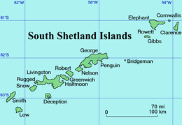 A map of the South Shetland Islands | |
 Gibbs Island Location of Gibbs Island  Gibbs Island Gibbs Island (Antarctica) | |
| Geography | |
|---|---|
| Location | Antarctica |
| Coordinates | 61°28′S 055°34′W |
| Archipelago | South Shetland Islands |
| Area | 22 km2 (8.5 sq mi) |
| Length | 13 km (8.1 mi) |
| Width | 2 km (1.2 mi) |
| Administration | |
| Administered under the Antarctic Treaty System | |
| Demographics | |
| Population | Uninhabited |
| Ethnic groups | None |
Description
Gibbs is a slender, east-west aligned island, some 13 km (8.1 mi) long, 2 km (1.2 mi) wide and 22 km2 (8 sq mi) in area. It is bordered to the south by Bransfield Strait and to the north by the Loper Channel. The isthmus of The Spit joins the main part of Gibbs Island in the west to Furse Peninsula in the east.[1]
Important Bird Area
A 369 ha tract of land comprising Furse Peninsula, The Spit and a small ice-free area on Gibbs Island west of The Spit has been identified as an Important Bird Area (IBA) by BirdLife International because it supports breeding colonies of about 1700 pairs of macaroni and 190 pairs of chinstrap penguins, as well as over 18,000 pairs of southern fulmars.[1]
See also
- Cape Plenty
- List of Antarctic and subantarctic islands
References
- "Gibbs Island East". BirdLife data zone: Important Bird Areas. BirdLife International. 2012. Archived from the original on 10 July 2007. Retrieved 30 December 2012.
Antarctica | ||||||||
|---|---|---|---|---|---|---|---|---|
| Geography |
|  | ||||||
| History |
| |||||||
| Politics |
| |||||||
| Society |
| |||||||
| Famous explorers |
| |||||||
| ||||||||
На других языках
[de] Gibbs Island
Gibbs Island (russisch Остров Рожнова .mw-parser-output .Latn{font-family:"Akzidenz Grotesk","Arial","Avant Garde Gothic","Calibri","Futura","Geneva","Gill Sans","Helvetica","Lucida Grande","Lucida Sans Unicode","Lucida Grande","Stone Sans","Tahoma","Trebuchet","Univers","Verdana"}Ostrow Roschnowa) ist eine unbewohnte Insel der Südlichen Shetlandinseln und liegt 20 km südwestlich von Elephant Island.- [en] Gibbs Island (South Shetland Islands)
[es] Isla Gibbs
La isla Gibbs es una isla de la Antártida situada a a 20 km al SSO de la isla Elefante, en las islas Shetland del Sur. Forma parte del grupo insular denominado por Chile como islas Piloto Pardo.[fr] Île Gibbs
L'île Gibbs est une île de l'Antarctique appartenant aux îles Shetland du Sud[1].[it] Isola Gibbs
L'isola Gibbs (in inglese Gibbs Island) è un'isola antartica localizzata ad una latitudine di 61° 28' sud e ad una longitudine di 55° 34' ovest 20 km a sudovest dell'isola Elephant. L'isola è stata cartografata per la prima volta nel 1825 da James Weddell della Royal Navy che ne ha scelto anche il nome. Il territorio fa parte dell'arcipelago delle Shetland meridionali e la sovranità è sospesa ai sensi del trattato antartico.[ru] Остров Рожнова
Остров Рожнова, также Гиббс (англ. Gibbs Island) — небольшой остров архипелага Южные Шетландские острова примерно в 20 километрах к юго-западу от острова Мордвинова (Элефант).Другой контент может иметь иную лицензию. Перед использованием материалов сайта WikiSort.org внимательно изучите правила лицензирования конкретных элементов наполнения сайта.
WikiSort.org - проект по пересортировке и дополнению контента Википедии