geo.wikisort.org - Island
Vardim Rocks (Bulgarian: скали Вардим, ‘Skali Vardim’ ska-'li 'var-dim) are a group of rocks situated on the south side of Hell Gates, facing Devils Point in the southwest extremity of Byers Peninsula on Livingston Island in the South Shetland Islands, Antarctica.[1] Extending 1.3 km (0.81 mi) in east-west direction. The two principal islets in the group, Demon and Sprite, are extending 420 by 400 m (460 by 440 yd) and 270 by 150 m (300 by 160 yd) respectively, with surface area of the former 9 hectares (22 acres).[2] The area was visited by early 19th century sealers.
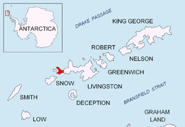 Location of Byers Peninsula, Livingston Island in the South Shetland Islands | |
| Geography | |
|---|---|
| Location | Antarctica |
| Coordinates | 62°40′28″S 61°11′00″W |
| Archipelago | South Shetland Islands |
| Administration | |
| Administered under the Antarctic Treaty System | |
| Demographics | |
| Population | Uninhabited |


The group includes the small islands of Demon (62°40′26″S 61°10′55″W), Sprite (62°40′23″S 61°11′31″W), and Imp (62°40′20″S 61°12′00″W).[3][4][5]
The rocks are named after the village of Vardim and the neighboring Vardim Island which is located on the Danube River in northern Bulgaria. Demon, Sprite and Imp islands are so named to reflect their proximity to Devils Point.
Location
Vardim Rocks are located at 62°40′28″S 61°11′00″W (British mapping in 1968, detailed Spanish mapping in 1992, and Bulgarian mapping in 2005, 2009 and 2010.
Maps
- Península Byers, Isla Livingston. Mapa topográfico a escala 1:25000. Madrid: Servicio Geográfico del Ejército, 1992.
- L.L. Ivanov. Antarctica: Livingston Island and Greenwich, Robert, Snow and Smith Islands. Scale 1:120000 topographic map. Troyan: Manfred Wörner Foundation, 2010. ISBN 978-954-92032-9-5 (First edition 2009. ISBN 978-954-92032-6-4)
- Antarctic Digital Database (ADD). Scale 1:250000 topographic map of Antarctica. Scientific Committee on Antarctic Research (SCAR). Since 1993, regularly upgraded and updated.
- L.L. Ivanov. Antarctica: Livingston Island and Smith Island. Scale 1:100000 topographic map. Manfred Wörner Foundation, 2017. ISBN 978-619-90008-3-0
See also
- Composite Antarctic Gazetteer
- List of Antarctic islands south of 60° S
- SCAR
- Territorial claims in Antarctica
Notes
- Vardim Rocks. SCAR Composite Antarctic Gazetteer.
- L.L. Ivanov. Antarctica: Livingston Island and Greenwich, Robert, Snow and Smith Islands. Scale 1:120000 topographic map. Troyan: Manfred Wörner Foundation, 2010. ISBN 978-954-92032-9-5 (First edition 2009. ISBN 978-954-92032-6-4)
- Demon Island. SCAR Composite Antarctic Gazetteer.
- Sprite Island. SCAR Composite Antarctic Gazetteer.
- Imp Island. SCAR Composite Antarctic Gazetteer.
References
- Bulgarian Antarctic Gazetteer. Antarctic Place-names Commission. (details in Bulgarian, basic data in English)
External links
- Vardim Rocks. Copernix satellite image
This article includes information from the Antarctic Place-names Commission of Bulgaria which is used with permission.
This Livingston Island location article is a stub. You can help Wikipedia by expanding it. |
На других языках
[de] Vardim Rocks
Die Vardim Rocks (englisch; bulgarisch скали Вардим .mw-parser-output .Latn{font-family:"Akzidenz Grotesk","Arial","Avant Garde Gothic","Calibri","Futura","Geneva","Gill Sans","Helvetica","Lucida Grande","Lucida Sans Unicode","Lucida Grande","Stone Sans","Tahoma","Trebuchet","Univers","Verdana"}skali Wardim) sind eine Kette kleiner Inseln und Klippenfelsen im Archipel der Südlichen Shetlandinseln. Vom Devils Point, dem südwestlichen Ausläufer der Byers-Halbinsel auf der Livingston-Insel, trennt sie nach Norden die Meerenge Hell Gates. Zu ihnen gehören Demon Island, Sprite Island und Imp Island.- [en] Vardim Rocks
Другой контент может иметь иную лицензию. Перед использованием материалов сайта WikiSort.org внимательно изучите правила лицензирования конкретных элементов наполнения сайта.
WikiSort.org - проект по пересортировке и дополнению контента Википедии