geo.wikisort.org - Island
Emeline Island is a conspicuous rocky island rising to over 100 m (328 ft) in the Aitcho group on the west side of English Strait in the South Shetland Islands, Antarctica. The island extends 550 by 320 m (600 by 350 yd) with a surface area of 18 hectares (44 acres).[1] The area was visited by early 19th century seal hunters.
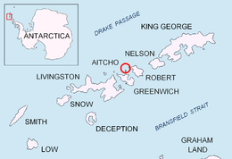 Location of Emeline Island in the South Shetland Islands | |
 Emeline Island Location of Emeline Island  Emeline Island Emeline Island (Antarctica) | |
| Geography | |
|---|---|
| Location | Antarctica |
| Coordinates | 62°24′S 59°48′W |
| Archipelago | Aitcho group |
| Area | 18 ha (44 acres) |
| Length | 0.55 km (0.342 mi) |
| Width | 0.32 km (0.199 mi) |
| Highest elevation | 100.0 m (328.1 ft) |
| Administration | |
| Administered under the Antarctic Treaty System | |
| Demographics | |
| Population | Uninhabited |

The feature is named after the American sealing vessel Emeline under Captain Jeremiah Holmes, which visited the South Shetlands in 1820–21 and operated from nearby Clothier Harbour.
Location
The midpoint is located at 62°23′29.3″S 59°47′35″W and the island lies 650 m (710 yd) northwest of Pasarel Island, 1.8 km (1.1 mi) northwest of Barrientos Island, 2.63 km (1.63 mi) north of Dee Island, 1.7 km (1.1 mi) north-northeast of Sierra Island, 2.45 km (1.52 mi) east by north of Stoker Island, 2 km (1.2 mi) east-southeast of Holmes Rock, 1.45 km (0.90 mi) southwest of Bilyana Island and 650 m (710 yd) southwest of Riksa Islands.[2]
See also
- Aitcho Islands
- Composite Antarctic Gazetteer
- List of Antarctic islands south of 60° S
- SCAR
- South Shetland Islands
- Territorial claims in Antarctica
Map
- L.L. Ivanov et al. Antarctica: Livingston Island and Greenwich Island, South Shetland Islands. Scale 1:100000 topographic map. Sofia: Antarctic Place-names Commission of Bulgaria, 2005.
References
- L.L. Ivanov. Antarctica: Livingston Island and Greenwich, Robert, Snow and Smith Islands. Scale 1:120000 topographic map. Troyan: Manfred Wörner Foundation, 2009. ISBN 978-954-92032-6-4
- British mapping in 1968, Chilean in 1971, Argentine in 1980, and Bulgarian in 2005 and 2009
External links
![]() This article incorporates public domain material from the United States Geological Survey document: "Emeline Island". (content from the Geographic Names Information System)
This article incorporates public domain material from the United States Geological Survey document: "Emeline Island". (content from the Geographic Names Information System)
Antarctica | ||||||||
|---|---|---|---|---|---|---|---|---|
| Geography |
|  | ||||||
| History |
| |||||||
| Politics |
| |||||||
| Society |
| |||||||
| Famous explorers |
| |||||||
| ||||||||
This Greenwich Island location article is a stub. You can help Wikipedia by expanding it. |
На других языках
[de] Emeline Island
Emeline Island ist eine kleine Insel im Archipel der Südlichen Shetlandinseln. In der Gruppe der Aitcho-Inseln in der English Strait liegt sie 3 km nordwestlich von Cecilia Island.- [en] Emeline Island
Другой контент может иметь иную лицензию. Перед использованием материалов сайта WikiSort.org внимательно изучите правила лицензирования конкретных элементов наполнения сайта.
WikiSort.org - проект по пересортировке и дополнению контента Википедии