geo.wikisort.org - Island
Barlow Island is a small ice-free island off the north coast of Smith Island in the South Shetland Islands, Antarctica extending 380 by 160 m (420 by 170 yd), surface area 5.28 hectares (13 acres).[1]
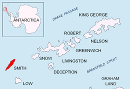 Location of Smith Island in the South Shetland Islands | |
 Barlow Island Location of Smith Island  Barlow Island Barlow Island (Antarctica) | |
| Geography | |
|---|---|
| Location | Antarctica |
| Coordinates | 62°52′04.5″S 62°20′24.2″W |
| Archipelago | South Shetland Islands |
| Area | 5.28 ha (13.0 acres) |
| Length | 0.38 km (0.236 mi) |
| Width | 0.16 km (0.099 mi) |
| Administration | |
| Administered under the Antarctic Treaty System | |
| Demographics | |
| Population | Uninhabited |

The feature's name, presumably honouring the British physicist and mathematician Peter Barlow (1776–1862), derives from the name 'Cape Barlow' originally applied in 1829 by the British naval expedition under Captain Henry Foster to some point on the east side of Smith Island.
Location
The island is located at 62°52′04.5″S 62°20′24.2″W which is 2.14 km (1.33 mi) west-northwest of Cape Smith, 1.06 km (0.66 mi) west-northwest of Alfeus Island, 2.42 km (1.50 mi) north-northeast of Matochina Peak, 2.48 km (1.54 mi) northeast of Delyan Point and 11.33 km (7.04 mi) northeast of Gregory Point (British mapping in 1957, Chilean in 1962, Argentine in 1991, and Bulgarian in 2009).
Maps
- Chart of South Shetland including Coronation Island, &c. from the exploration of the sloop Dove in the years 1821 and 1822 by George Powell Commander of the same. Scale ca. 1:200000. London: Laurie, 1822.
- L.L. Ivanov. Antarctica: Livingston Island and Greenwich, Robert, Snow and Smith Islands. Scale 1:120000 topographic map. Troyan: Manfred Wörner Foundation, 2010. ISBN 978-954-92032-9-5 (First edition 2009. ISBN 978-954-92032-6-4)
- South Shetland Islands: Smith and Low Islands. Scale 1:150000 topographic map No. 13677. British Antarctic Survey, 2009.
- Antarctic Digital Database (ADD). Scale 1:250000 topographic map of Antarctica. Scientific Committee on Antarctic Research (SCAR). Since 1993, regularly upgraded and updated.
- L.L. Ivanov. Antarctica: Livingston Island and Smith Island. Scale 1:100000 topographic map. Manfred Wörner Foundation, 2017. ISBN 978-619-90008-3-0
See also
- Composite Antarctic Gazetteer
- List of Antarctic islands south of 60° S
- SCAR
- Territorial claims in Antarctica
References
- L.L. Ivanov. Antarctica: Livingston Island and Greenwich, Robert, Snow and Smith Islands. Archived April 24, 2008, at the Wayback Machine Scale 1:120000 topographic map. Troyan: Manfred Wörner Foundation, 2009. ISBN 978-954-92032-6-4
External links
Antarctica | ||||||||
|---|---|---|---|---|---|---|---|---|
| Geography |
|  | ||||||
| History |
| |||||||
| Politics |
| |||||||
| Society |
| |||||||
| Famous explorers |
| |||||||
| ||||||||
This Smith Island (South Shetland Islands) location article is a stub. You can help Wikipedia by expanding it. |
На других языках
[de] Barlow Island
Barlow Island ist eine kleine Insel im Archipel der Südlichen Shetlandinseln. Sie liegt 1,5 km westnordwestlich des Kap Smith, der Nordspitze von Smith Island.- [en] Barlow Island
Другой контент может иметь иную лицензию. Перед использованием материалов сайта WikiSort.org внимательно изучите правила лицензирования конкретных элементов наполнения сайта.
WikiSort.org - проект по пересортировке и дополнению контента Википедии