geo.wikisort.org - Island
Greenwich Island (variant historical names Sartorius Island, Berezina Island) is an island 24 km (15 mi) long and from 0.80 to 9.66 km (0.5 to 6 mi) (average 5.23 km or 3.25 mi) wide, lying between Robert Island and Livingston Island in the South Shetland Islands. Surface area 142.7 square kilometres (55.1 sq mi).[1] The name Greenwich Island dates back to at least 1821 and is now established in international usage.
 Greenwich Island from Half Moon Island | |
 Greenwich Island Location in the South Shetland Islands  Greenwich Island Location in Antarctica | |
| Geography | |
|---|---|
| Location | Antarctica |
| Coordinates | 62°31′S 59°47′W |
| Archipelago | South Shetland Islands |
| Area | 142.7 km2 (55.1 sq mi) |
| Length | 24 km (14.9 mi) |
| Width | 5.23 km (3.25 mi) |
| Highest elevation | 625 m (2051 ft) |
| Highest point | Momchil Peak |
| Administration | |
| Administered under the Antarctic Treaty System | |
| Demographics | |
| Population | 0 |
The Chilean base Arturo Prat and the Ecuadorian base Pedro Vicente Maldonado are situated on the northeast and north coast of the island respectively.
Chilean scientists have claimed that Amerinds visited the area, due to stone artifacts recovered from bottom-sampling operations off the island;[2] however, the artefacts — two arrowheads — were later found to have been planted.[3][4]
See also
- Breznik Heights
- Composite Antarctic Gazetteer
- Dryanovo Heights
- List of Antarctic islands south of 60° S
- SCAR
- Tangra 2004/05 Expedition
- Territorial claims in Antarctica
Maps
- Chart of South Shetland including Coronation Island, &c. from the exploration of the sloop Dove in the years 1821 and 1822 by George Powell Commander of the same. Scale ca. 1:200000. London: Laurie, 1822.
- L.L. Ivanov et al. Antarctica: Livingston Island and Greenwich Island, South Shetland Islands (from English Strait to Morton Strait, with illustrations and ice-cover distribution). Scale 1:100000 topographic map. Sofia: Antarctic Place-names Commission of Bulgaria, 2005.
- L.L. Ivanov. Antarctica: Livingston Island and Smith Island. Scale 1:100000 topographic map. Manfred Wörner Foundation, 2017. ISBN 978-619-90008-3-0
References
- L.L. Ivanov. Antarctica: Livingston Island and Greenwich, Robert, Snow and Smith Islands. Scale 1:120000 topographic map. Troyan: Manfred Wörner Foundation, 2010. ISBN 978-954-92032-9-5 (First edition 2009. ISBN 978-954-92032-6-4)
- G. Hattersley-Smith (June 1983). "Fuegian Indians in the Falkland Islands". Polar Record. Cambridge University Press. 21 (135): 605–606. doi:10.1017/S003224740002204X.
- "Authentication of aboriginal remains in the South Shetland Islands". NASA. 2012-10-15. Archived from the original on 2014-01-02. Retrieved 2 January 2014.
 This article incorporates text from this source, which is in the public domain.
 - Griffiths, Tom (2007). Slicing the Silence: Voyaging to Antarctica. Harvard University Press. pp. 344–345. ISBN 978-0674026339.
Gallery
 Fragment of George Powell's 1822 chart of the South Shetland Islands and South Orkney Islands featuring Greenwich Island
 Topographic map of Livingston Island, Greenwich, Robert, Snow and Smith Islands
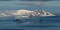 Breznik Heights, Greenwich Island from near Camp Academia, with Half Moon Island and McFarlane Strait in the foreground
 Fort Point and St. Kiprian Peak, Greenwich Island from Bransfield Strait


External links
Antarctica | ||||||||
|---|---|---|---|---|---|---|---|---|
| Geography |
|  | ||||||
| History |
| |||||||
| Politics |
| |||||||
| Society |
| |||||||
| Famous explorers |
| |||||||
| ||||||||
| Authority control |
|
|---|
This Greenwich Island location article is a stub. You can help Wikipedia by expanding it. |
На других языках
[de] Greenwich Island
Greenwich Island (historische Namen: Sartorius Island, Berezina Island) ist eine Insel der Südlichen Shetlandinseln. Sie hat eine Länge von 24 km, eine Breite zwischen 0,8 und 10 km und weist eine Fläche von 173,8 km² auf.[1] Sie liegt in der Südgruppe des Archipels zwischen Robert Island im Nordosten und Livingston Island im Südwesten und wird von diesen getrennt durch die Englische und die McFarlane-Straße. Die höchste Erhebung der stark vergletscherten Insel ist der 625 m hohe Momchil Peak.- [en] Greenwich Island
[es] Isla Greenwich
La isla Greenwich es una de las islas que forman el archipiélago de las islas Shetland del Sur en la Antártida. Está ubicada a 62°31′S 59°47′O entre la isla Robert al noreste, separadas por el estrecho Inglés, y la isla Livingston al suroeste, separadas por el estrecho McFarlane.[fr] Île Greenwich
L'île Greenwich est une île faisant partie des Shetland du Sud. Située entre l'île Robert au nord-est, dont elle est séparée par le détroit Anglais, et l'île Livingston au sud-ouest, dont elle est séparée par le détroit McFarlane.[it] Isola Greenwich
L’Isola Greenwich (in lingua inglese: Greenwich Island; varianti storiche del nome: Sartorius Island, Berezina Island) è la seconda per dimensione delle isole che compongono l'arcipelago delle Isole Shetland Meridionali, in Antartide.[ru] Гринидж (остров)
Остров Гринидж (англ. Greenwich), известен также как Остров Березина[1] — один из островов архипелага Южные Шетландские острова. Лежит между островами Ливингстон и Роберт (Полоцк). Общая площадь суши — 142,7 км²[2].Другой контент может иметь иную лицензию. Перед использованием материалов сайта WikiSort.org внимательно изучите правила лицензирования конкретных элементов наполнения сайта.
WikiSort.org - проект по пересортировке и дополнению контента Википедии