geo.wikisort.org - Insel
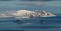
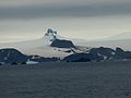
Greenwich Island (historische Namen: Sartorius Island, Berezina Island) ist eine Insel der Südlichen Shetlandinseln. Sie hat eine Länge von 24 km, eine Breite zwischen 0,8 und 10 km und weist eine Fläche von 173,8 km² auf.[1] Sie liegt in der Südgruppe des Archipels zwischen Robert Island im Nordosten und Livingston Island im Südwesten und wird von diesen getrennt durch die Englische und die McFarlane-Straße. Die höchste Erhebung der stark vergletscherten Insel ist der 625 m hohe Momchil Peak.
| Greenwich Island | ||
|---|---|---|
 | ||
| Gewässer | Südlicher Ozean | |
| Inselgruppe | Südliche Shetlandinseln | |
| Geographische Lage | 62° 31′ S, 59° 47′ W | |
| ||
| Länge | 24 km | |
| Breite | 10 km | |
| Fläche | 173,8 km² | |
| Höchste Erhebung | Momchil Peak 625 m | |
| Einwohner | 9 Stationspersonal im Winter <1 Einw./km² | |
| Hauptort | (Arturo-Prat-Station) | |
 | ||

Die chilenische Forschungsstation Arturo Prat und die ecuadorianische Station Pedro Vicente Maldonado liegen an der Discovery Bay im Nordosten der Insel.
Die Bezeichnung Greenwich Island datiert zurück auf das Jahr 1821 oder noch früher und hat sich als gängiger Name der Insel durchgesetzt.

 Arturo-Prat-Station


Karten

- L. L. Ivanov et al.: Antarctica: Livingston Island and Greenwich Island, South Shetland Islands (from English Strait to Morton Strait, with illustrations and ice-cover distribution). Topografische Karte im Maßstab 1:100.000, Antarctic Place-names Commission of Bulgaria, Sofia 2005.
- L. L. Ivanov: Antarctica: Livingston Island and Greenwich, Robert, Snow and Smith Islands. Topografische Karte im Maßstab 1:120.000. Manfred-Wörner-Stiftung, Troyan, 2009. ISBN 978-954-92032-6-4
Weblinks
Einzelnachweise
- UNEP Islands (englisch)
На других языках
- [de] Greenwich Island
[es] Isla Greenwich
La isla Greenwich es una de las islas que forman el archipiélago de las islas Shetland del Sur en la Antártida. Está ubicada a 62°31′S 59°47′O entre la isla Robert al noreste, separadas por el estrecho Inglés, y la isla Livingston al suroeste, separadas por el estrecho McFarlane.[fr] Île Greenwich
L'île Greenwich est une île faisant partie des Shetland du Sud. Située entre l'île Robert au nord-est, dont elle est séparée par le détroit Anglais, et l'île Livingston au sud-ouest, dont elle est séparée par le détroit McFarlane.[it] Isola Greenwich
L’Isola Greenwich (in lingua inglese: Greenwich Island; varianti storiche del nome: Sartorius Island, Berezina Island) è la seconda per dimensione delle isole che compongono l'arcipelago delle Isole Shetland Meridionali, in Antartide.[ru] Гринидж (остров)
Остров Гринидж (англ. Greenwich), известен также как Остров Березина[1] — один из островов архипелага Южные Шетландские острова. Лежит между островами Ливингстон и Роберт (Полоцк). Общая площадь суши — 142,7 км²[2].Другой контент может иметь иную лицензию. Перед использованием материалов сайта WikiSort.org внимательно изучите правила лицензирования конкретных элементов наполнения сайта.
WikiSort.org - проект по пересортировке и дополнению контента Википедии