geo.wikisort.org - Island
Ritchie Rock (Bulgarian: скала Ричи, romanized: skala Ritchie, IPA: [skɐˈla ˈrit͡ʃi]) is the conspicuous rock off the southwest coast of Snow Island in the South Shetland Islands, Antarctica extending 80 m in south-north direction and 73 m in west-east direction, with a surface area of 0.17 ha. The vicinity was visited by early 19th century sealers.[1]
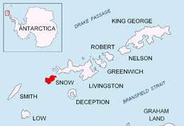 Location of Snow Island in the South Shetland Islands | |
 Ritchie Rock Location of Ritchie Rock  Ritchie Rock Ritchie Rock (South Shetland Islands) | |
| Geography | |
|---|---|
| Location | Antarctica |
| Coordinates | 62°51′03″S 61°22′35.5″W |
| Archipelago | South Shetland Islands |
| Area | 0.17 ha (0.42 acres) |
| Length | 80 m (260 ft) |
| Width | 73 m (240 ft) |
| Administration | |
| Administered under the Antarctic Treaty | |
| Demographics | |
| Population | uninhabited |

The feature is named after Edward Samuel Ritchie (1814-1895), an American inventor and physicist who created a waterborne version of the theodolite used in harbour surveys; in association with other names in the area deriving from the early development or use of geodetic instruments and methods.
Location
Ritchie Rock is located at 62°51′03″S 61°22′35.5″W,[2] which is 2.6 km east-northeast of Tooth Rock, 2.84 km east-southeast of Cape Conway and 1.82 km south-southeast of Pazardzhik Point. Bulgarian mapping in 2009.
See also
Maps
- South Shetland Islands. Scale 1:200000 topographic map. DOS 610 Sheet W 62 60. Tolworth, UK, 1968
- L. Ivanov. Antarctica: Livingston Island and Greenwich, Robert, Snow and Smith Islands. Scale 1:120000 topographic map. Troyan: Manfred Wörner Foundation, 2010. ISBN 978-954-92032-9-5 (First edition 2009. ISBN 978-954-92032-6-4)
- Antarctic Digital Database (ADD). Scale 1:250000 topographic map of Antarctica. Scientific Committee on Antarctic Research (SCAR). Since 1993, regularly upgraded and updated
Notes
- L. Ivanov. General Geography and History of Livingston Island. In: Bulgarian Antarctic Research: A Synthesis. Eds. C. Pimpirev and N. Chipev. Sofia: St. Kliment Ohridski University Press, 2015. pp. 17–28
- Bulgarian Antarctic Gazetteer. Antarctic Place-names Commission
References
- Bulgarian Antarctic Gazetteer. Antarctic Place-names Commission. (details in Bulgarian, basic data in English)
External links
- Ritchie Rock. Adjusted Copernix satellite image
This article includes information from the Antarctic Place-names Commission of Bulgaria which is used with permission.
This Snow Island location article is a stub. You can help Wikipedia by expanding it. |
На других языках
[de] Ritchie Rock
Der Richie Rock (englisch; bulgarisch скала Ричи .mw-parser-output .Latn{font-family:"Akzidenz Grotesk","Arial","Avant Garde Gothic","Calibri","Futura","Geneva","Gill Sans","Helvetica","Lucida Grande","Lucida Sans Unicode","Lucida Grande","Stone Sans","Tahoma","Trebuchet","Univers","Verdana"}skala Ritschi) ist ein in nord-südlicher Ausrichtung 80 m langer und 73 m breiter Klippenfelsen vor der Südküste von Snow Island im Archipel der Südlichen Shetlandinseln. Er liegt 2,6 km ostnordöstlich des Tooth Rock, 2,84 km ostsüdöstlich des Kap Conway und 1,82 km südsüdöstlich des Pazardzhik Point.- [en] Ritchie Rock
Другой контент может иметь иную лицензию. Перед использованием материалов сайта WikiSort.org внимательно изучите правила лицензирования конкретных элементов наполнения сайта.
WikiSort.org - проект по пересортировке и дополнению контента Википедии