geo.wikisort.org - Island
Half Moon Island is a minor Antarctic island, lying in McFarlane Strait 1.35 km (0.84 mi) north of Burgas Peninsula, Livingston Island in the South Shetland Islands of the Antarctic Peninsula region. Its surface area is 171 hectares (420 acres).[1] The Argentine Cámara Base is located on the island. It is only accessible by sea and by helicopter; there is no airport of any kind. The naval base is operational occasionally during the summer, but is closed during the winter.
 Half Moon Island from Kuzman Knoll, Livingston Island, with Greenwich Island in the background | |
 | |
 Half Moon Island Location on Antarctic Peninsula  Half Moon Island Location in Antarctica | |
| Geography | |
|---|---|
| Location | Antarctica |
| Coordinates | 62°35′24″S 59°54′36″W |
| Archipelago | South Shetland Islands |
| Area | 171 ha (420 acres) |
| Administration | |
| Administered under the Antarctic Treaty System | |
| Demographics | |
| Population | Uninhabited |

Geography
The island is a series of gravel bars (tombolos) connecting volcanic bedrock islands. The volcanism is not recent and may be millions of years old. The crescent shaped island may be the result of an eroded caldera similar to the much more recent Deception Island volcano complex. The parallel gravel bars are a result of post-glacial (isostatic) uplift of the area after the much larger Pleistocene ice cap melted and the pressure was released.
Wildlife
Plants found on the island include several lichen and moss species as well as Antarctic Hairgrass.[1]
The island has been identified as an Important Bird Area (IBA) by BirdLife International because it supports a breeding colony of about 100 pairs of south polar skuas. Other birds nesting on the island include chinstrap penguins (2000 pairs), Antarctic terns (125 pairs), kelp gulls (40 pairs), Wilson's and black-bellied storm petrels, Cape petrels, brown skuas, snowy sheathbills and imperial shags.[1]
Weddell and Antarctic fur seals regularly haul out on the beaches. Southern elephant seals have been recorded.[1] Whales are often seen patrolling the shores.
Access
The island is used as a stop during Antarctic cruises, with the peak of visitation during November–March. There is a 2,000 m (2,200 yd) walking track on the southern part of the Island which allows tourists to get a close view of the wildlife (mainly chinstrap penguins and skuas), and of the surrounding mountainous scenery of nearby Livingston and Greenwich Islands. The path begins on the south side of Menguante Cove, runs westwards along the beach to Cámara Base, then turns north along the head of Menguante Cove, and eventually ascends northeastwards to the top of Xenia Hill.[2]
Google Street View
In September 2010, Google added Street View imagery of Half Moon Island to its Google Earth and Google Maps services.[3] The expansion of Google Street View onto the island means all seven continents had imagery through the service.[4] As the island has no roads, the images appear to have been taken with a camera on a tripod. The shadow of the photographer can clearly be seen if one were to move the view so as to look at the ground. Also, the iconic Pegman from Google was replaced with a Penguin, due to the island's use as a breeding colony by them. The penguin has since been changed back to Pegman.[citation needed]
See also
- Composite Antarctic Gazetteer
- List of Antarctic islands south of 60° S
- Livingston Island
- Saddleback Ridge
- SCAR
- Territorial claims in Antarctica
Maps
- Chart of South Shetland including Coronation Island, &c. from the exploration of the sloop Dove in the years 1821 and 1822 by George Powell Commander of the same. Scale ca. 1:200000. London: Laurie, 1822.
- L.L. Ivanov et al., Antarctica: Livingston Island and Greenwich Island, South Shetland Islands (from English Strait to Morton Strait, with illustrations and ice-cover distribution), 1:100000 scale topographic map, Antarctic Place-names Commission of Bulgaria, Sofia, 2005
- L.L. Ivanov. Antarctica: Livingston Island and Greenwich, Robert, Snow and Smith Islands. Scale 1:120000 topographic map. Troyan: Manfred Wörner Foundation, 2009. ISBN 978-954-92032-6-4
- Antarctic Digital Database (ADD). Scale 1:250000 topographic map of Antarctica. Scientific Committee on Antarctic Research (SCAR). Since 1993, regularly updated.
- L.L. Ivanov. Antarctica: Livingston Island and Smith Island. Scale 1:100000 topographic map. Manfred Wörner Foundation, 2017. ISBN 978-619-90008-3-0
Gallery
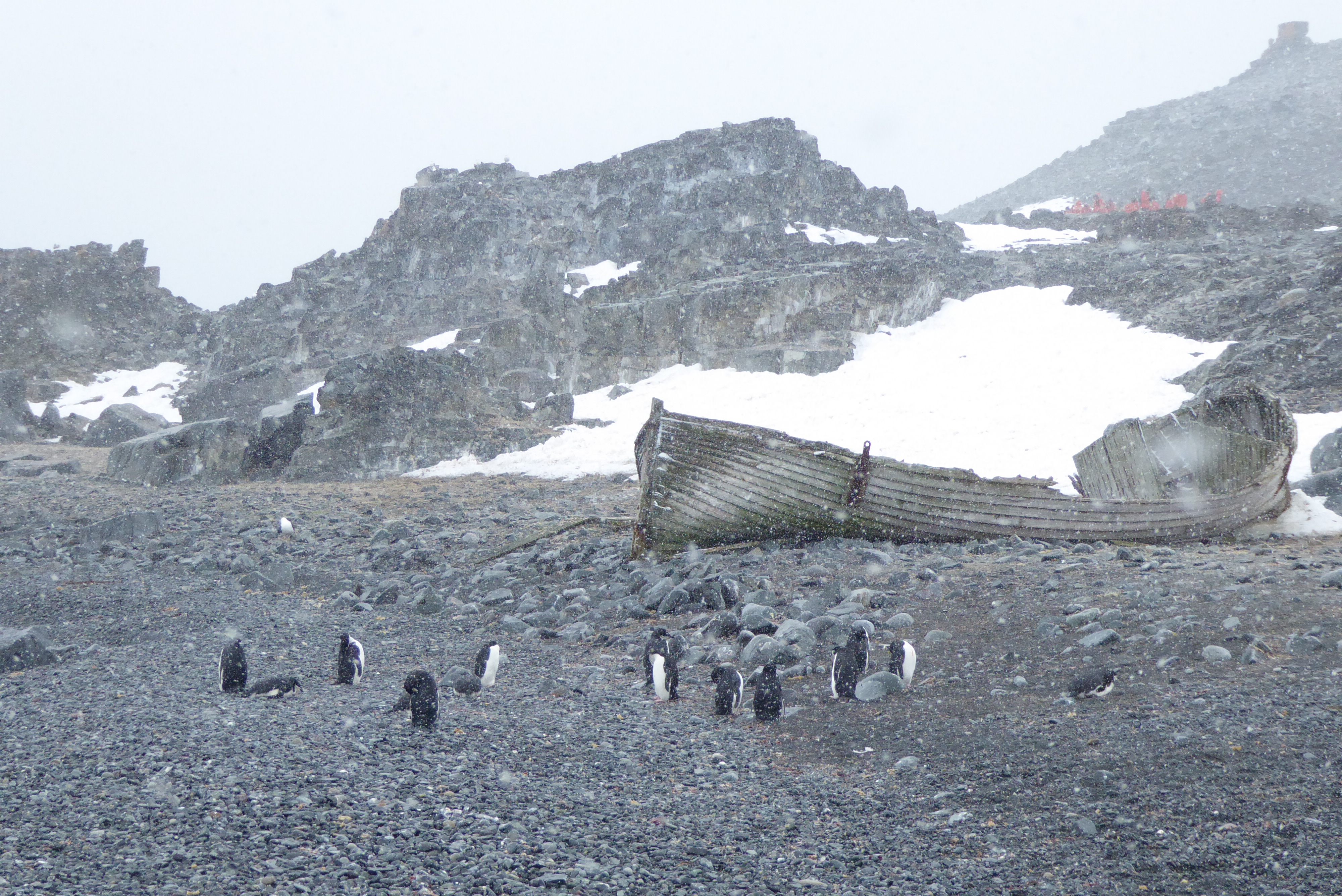
 The wreck of an old whaling boat, located at the south end of Island.
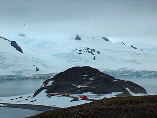 Cámara Base and Morenita Hill from Xenia Hill.
 View of Cámara Base.
 Half Moon Island map
 Topographic map of Livingston Island


References
- "Half Moon Island". BirdLife data zone: Important Bird Areas. BirdLife International. 2013. Archived from the original on 14 February 2016. Retrieved 1 January 2013.
{{cite web}}: CS1 maint: bot: original URL status unknown (link) - Google (13 March 2012). "Half Moon Trail" (Map). Google Maps. Google. Retrieved 13 March 2012.
- "Official Google Blog: Explore the world with Street View, now on all seven continents". Google. 30 September 2010. Retrieved 2 October 2010.
- Halliday, Josh (30 September 2010). "Google Street View: No more privacy for penguins as Antarctica gets mapped". The Guardian. London. Retrieved 13 March 2012.
External links
- Images from Half Moon Island
- Videos and photographs of birds of Half Moon Island (including chinstrap penguin, Antarctic shag, pale-faced sheathbill, Wilson's storm petrel and kelp gull) on the Internet Bird Collection
- "Google Street View hits Antarctic". BBC.
Antarctica | ||||||||
|---|---|---|---|---|---|---|---|---|
| Geography |
|  | ||||||
| History |
| |||||||
| Politics |
| |||||||
| Society |
| |||||||
| Famous explorers |
| |||||||
| ||||||||
На других языках
[de] Half Moon Island
Half Moon Island (englisch für Halbmondinsel, spanisch Isla Media Luna) ist eine kleine, subantarktische Insel im Archipel der Südlichen Shetlandinseln. Sie liegt 1300 Meter nordwestlich von Livingston Island in der McFarlane Strait, die Livingston von Greenwich Island trennt. Von der Antarktischen Halbinsel ist Half Moon Island etwa 120 km entfernt.- [en] Half Moon Island
[es] Isla Media Luna
La isla Media Luna es una isla del archipiélago de las Shetland del Sur en la Antártida. Se ubica a 62°35′44″S 59°54′12″O en entrada de la bahía Luna en el lado este de la isla Livingston, a unos 120 km al norte de la península Antártica.[fr] Île Half Moon
L’île Half Moon (Îles Shetland du Sud) est une île de l'Antarctique, se trouvant à 1,35 km au nord de la péninsule Burgas (Île Livingston) dans la région de la péninsule Antarctique. L'île couvre une superficie de 51 hectares[1].[it] Isola Half Moon
L'isola Half Moon (in inglese Half Moon Island, in spagnolo isla Media Luna) è un'isola antartica localizzata ad una latitudine di 62° 35' sud e ad una longitudine di 59° 54' ovest.[ru] Хаф-Мун
Хаф-Мун (англ. Half Moon Island) — небольшой антарктический остров в архипелаге Южные Шетландские острова, находится примерно в 120 километрах к северу от Антарктического полуострова.Другой контент может иметь иную лицензию. Перед использованием материалов сайта WikiSort.org внимательно изучите правила лицензирования конкретных элементов наполнения сайта.
WikiSort.org - проект по пересортировке и дополнению контента Википедии