geo.wikisort.org - Coast
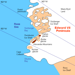
King Edward VII Land or King Edward VII Peninsula is a large, ice-covered peninsula which forms the northwestern extremity of Marie Byrd Land in Antarctica.[1] The peninsula projects into the Ross Sea between Sulzberger Bay and the northeast corner of the Ross Ice Shelf, and forms part of the Ross Dependency. Edward VII Peninsula is defined by the Ross Ice Shelf on the southwest, Okuma Bay on the west, and to the east by Sulzberger Bay and the Saunders Coast, all essentially on the Ross Sea / Southern Ocean in Antarctica. The northwest extremity of the peninsula is Cape Colbeck. Edward VII Peninsula is located at 77°40′S 155°00′W.
This article relies largely or entirely on a single source. (November 2021) |


The western coast is Shirase Coast. In the north and east the Swinburne Ice Shelf is located. Edward VII Peninsula was discovered on 30 January 1902 by the British National Antarctic Expedition (BrNAE) (1901–1904) under Robert Falcon Scott, who named it King Edward VII Land for King Edward VII of the United Kingdom. The coastline was further explored by the Nimrod Expedition under Ernest Shackleton in 1908–09, and the first landfall was made by a party of the Japanese Antarctic Expedition led by Shirase Nobu in 1912. The region was renamed "Edward VII Peninsula" after the peninsular character of the region was determined by exploration conducted by the Byrd Antarctic Expedition (1933–1935) and the United States Antarctic Service (USAS) Expedition (1939–1941).
Most of the peninsula is within the Ross Dependency, claimed by New Zealand (see Territorial claims of Antarctica).
Gallery
 New Zealand stamp overprinted for use at the British base
See also
- Fokker Rocks
References
- Wade, F. Alton (1945). "The Geology of the Rockefeller Mountains, King Edward VII Land, Antarctica". Proceedings of the American Philosophical Society. 89 (1): 67–77.
На других языках
[de] Edward-VII-Halbinsel
Die Edward-VII-Halbinsel (auch König-Eduard-VII.-Halbinsel oder König-Eduard-VII.-Land) ist eine antarktische Halbinsel im Nordwesten des Marie-Byrd-Lands. Nordöstlich der eisbedeckten Halbinsel befindet sich die Sulzberger Bay, während im Südwesten das Ross-Schelfeis anschließt. Der am weitesten ins Rossmeer hinausragende Punkt und gleichzeitig der östlichste Punkt des offenen Rossmeers ist Kap Colbeck (die weiter südlich befindliche Siple-Küste reicht weiter nach Osten, ist aber vom Ross-Schelfeis bedeckt). Südlich von Kap Colbeck liegt die Shirase-Küste, östlich davon die Saunders-Küste. Auf der Halbinsel befinden sich mit den Rockefeller Mountains und den Alexandra Mountains zwei Gebirge.- [en] King Edward VII Land
[es] Península de Eduardo VII
La península de Eduardo VII o Tierra del Rey Eduardo VII o península del Rey Eduardo VII, es una gran península helada de la Antártida que forma el extremo nordoccidental de la Tierra de Marie Byrd, punto de inicio del mar de Ross, entre la bahía Sulzberger y el extremo nordeste de la barrera de hielo de Ross. La península de Eduardo VII está definida por esta barrera de hielo, en el suroeste, por la bahía Okuma, en el oeste, y, en el este, por la bahía Sulzberger y la costa Saunders.Другой контент может иметь иную лицензию. Перед использованием материалов сайта WikiSort.org внимательно изучите правила лицензирования конкретных элементов наполнения сайта.
WikiSort.org - проект по пересортировке и дополнению контента Википедии
