geo.wikisort.org - Île
L’île Half Moon (Îles Shetland du Sud) est une île de l'Antarctique, se trouvant à 1,35 km au nord de la péninsule Burgas (Île Livingston) dans la région de la péninsule Antarctique. L'île couvre une superficie de 51 hectares[1].
Cet article est une ébauche concernant le monde insulaire.
Vous pouvez partager vos connaissances en l’améliorant (comment ?) selon les recommandations des projets correspondants.
| Île Half Moon | ||
 L'île Half Moon. | ||
| Géographie | ||
|---|---|---|
| Continent | ||
| Archipel | Îles Shetland du Sud | |
| Localisation | Océan Austral | |
| Coordonnées | 62° 35′ 44″ S, 59° 54′ 12″ O | |
| Superficie | 0,051 km2 | |
| Point culminant | Colline Gabriel (101 m) | |
| Administration | ||
| Secteur | Territoire chilien de l'Antarctique, Territoire britannique antarctique, Antarctique argentine | |
| Démographie | ||
| Population | Aucun habitant | |
| Autres informations | ||
| Géolocalisation sur la carte : Antarctique
| ||
| Îles en Antarctique | ||
| modifier |
||


Faune
L'île abrite une colonie de manchots à jugulaire et est aussi le lieu de nidification de sternes arctiques et goélands dominicains. Des baleines sont souvent vues au large du rivage.
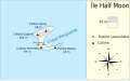 Carte de l'île.

Station
La station argentine Base Teniente Cámara se trouve sur l'île.
En septembre 2010, Google a ajouté l'imagerie Street View d'une partie de l'île Half Moon à ses services Google Earth et Google Maps[2]. Puisque l'île n'a pas de route, les images ont été prises à l'aide d'un appareil photo transporté par des piétons.
Sources
Références
- Ivanov 2009
- (en) « Official Google Blog: Explore the world with Street View, now on all seven continents », Google, (consulté le )
Bibliographie
- L. L. Ivanov, Antarctica: Livingston Island and Greenwich, Robert, Snow and Smith Islands. Scale 1:120000 topographic map., Troyan: Manfred Wörner Foundation, (ISBN 978-954-92032-6-4, lire en ligne)
 Portail de l’Antarctique
  Portail du monde insulaire
  Portail des Territoires britanniques d'outre-mer
  Portail du Chili
  Portail de l’Argentine
На других языках
[de] Half Moon Island
Half Moon Island (englisch für Halbmondinsel, spanisch Isla Media Luna) ist eine kleine, subantarktische Insel im Archipel der Südlichen Shetlandinseln. Sie liegt 1300 Meter nordwestlich von Livingston Island in der McFarlane Strait, die Livingston von Greenwich Island trennt. Von der Antarktischen Halbinsel ist Half Moon Island etwa 120 km entfernt.[en] Half Moon Island
Half Moon Island is a minor Antarctic island, lying in McFarlane Strait 1.35 km (0.84 mi) north of Burgas Peninsula, Livingston Island in the South Shetland Islands of the Antarctic Peninsula region. Its surface area is 171 hectares (420 acres).[1] The Argentine Cámara Base is located on the island. It is only accessible by sea and by helicopter; there is no airport of any kind. The naval base is operational occasionally during the summer, but is closed during the winter.[es] Isla Media Luna
La isla Media Luna es una isla del archipiélago de las Shetland del Sur en la Antártida. Se ubica a 62°35′44″S 59°54′12″O en entrada de la bahía Luna en el lado este de la isla Livingston, a unos 120 km al norte de la península Antártica.- [fr] Île Half Moon
[it] Isola Half Moon
L'isola Half Moon (in inglese Half Moon Island, in spagnolo isla Media Luna) è un'isola antartica localizzata ad una latitudine di 62° 35' sud e ad una longitudine di 59° 54' ovest.[ru] Хаф-Мун
Хаф-Мун (англ. Half Moon Island) — небольшой антарктический остров в архипелаге Южные Шетландские острова, находится примерно в 120 километрах к северу от Антарктического полуострова.Другой контент может иметь иную лицензию. Перед использованием материалов сайта WikiSort.org внимательно изучите правила лицензирования конкретных элементов наполнения сайта.
WikiSort.org - проект по пересортировке и дополнению контента Википедии